High Country Web Design LLC

Welcome to Payson
The History of Rim Country

“For wild, rugged beauty I had not seen its equal.”
— Zane Grey, describing the Mogollon Rim and Tonto Basin
The Untold Stories Of Payson
"The worst days make the best stories."
- Milo Shapiro
A Historical Story of Payson, Arizona Payson did not begin with paved streets, storefronts, or a name painted on a highway sign. It began with water, timber, open country, and the immense wall of the Mogollon Rim rising to the north. Long before the first American settlers built cabins in the valley, Native peoples lived, hunted, farmed, and traveled throughout Rim Country. Ancient communities left behind traces of their lives in the surrounding canyons and mesas. In later centuries, the region became home to the Yavapai and Tonto Apache, whose history remains inseparable from the land. By the early 1880s, ranchers, miners, loggers, and their families had begun forming a small settlement beneath the Rim. In 1882, approximately forty residents established a townsite they officially called Union Park. Most people, however, simply called it Green Valley. It was a hopeful name for a difficult place. The surrounding country was beautiful, but beauty did not make life easy. Supplies arrived over rough trails, storms could turn dry washes into dangerous rivers, and a journey to another community might take days. Residents depended upon one another because there was often no one else close enough to help. A rancher might repair a neighbor’s roof before the winter snow. A family with a good harvest might share food with one that had suffered through a dry year. News traveled slowly, usually carried by a rider, a passing wagon, or a letter that had already crossed hundreds of miles. Then, in 1884, the mail finally found Green Valley. With the assistance of an Illinois congressman, the isolated settlement received its own post office. The community was renamed Payson in the congressman’s honor. The change may have appeared small—a different name written across envelopes and nailed above a doorway—but it meant something important. The settlement now had an official place on the map. Letters no longer had to depend entirely upon distant post offices and uncertain delivery arrangements. A message addressed to Payson, Arizona Territory, had somewhere definite to go. Families could receive news from relatives in distant states. Ranchers could conduct business beyond the valley. The name Payson began traveling across the country long before most Americans knew where the town was. That same year, another Payson tradition was born. During the third weekend of August, local cowboys and ranchers gathered in an open pasture to discover whose horse was fastest, who could rope with the greatest accuracy, and who could remain aboard a determined bronco. There were no grandstands, electric lights, loudspeakers, or large cash prizes. There were simply working cowboys testing the skills they used every day. People came to watch, visit, trade stories, and briefly set aside the demands of frontier life. The gathering became known as the August Doin’s and continued year after year, eventually earning Payson recognition for the World’s Oldest Continuous Rodeo. No one attending that first competition could have known what it would become. That is the peculiar nature of tradition: it often begins as an ordinary gathering that people care enough to repeat. As Payson entered the twentieth century, the forests and ranchlands remained central to its identity. Cattle, sheep, goats, logging operations, and small sawmills supported local families, but heavy use also damaged portions of the surrounding land. The establishment of the Tonto National Forest in 1907 brought new oversight intended to protect the forests and watersheds. Payson remained remote, and perhaps that remoteness was part of its attraction. Western author Zane Grey first visited Rim Country in 1918. Captivated by the rugged forests and canyons, he later built a hunting lodge beneath the Rim and returned for several years to hunt and write. His stories helped introduce readers across America to the wild character of Arizona’s high country. Visitors inspired by those stories still faced an exhausting journey. Early roads were steep, rough, and unreliable. A trip from Phoenix could consume most of the day, with travelers stopping to repair tires, cool overheated engines, or work vehicles free from mud and loose rock. For decades, Payson remained a place people reached deliberately. Nobody arrived there by accident. That changed in 1958 when the paved Beeline Highway connected Payson more directly with the Valley. The new road transformed the town. What had once been an isolated ranching and logging community became an accessible mountain destination. Families from Phoenix could escape the desert heat and reach the pine country in hours rather than spending an entire day struggling over primitive roads. New residents arrived. Businesses opened. Homes spread across the valley. In 1973, Payson officially incorporated as a town. Yet growth never completely erased the character of the old settlement. The rodeo still returns each year. Main Street still carries memories of ranchers, loggers, merchants, and travelers. The surrounding forests continue to shape the rhythm of life, from winter snow and summer monsoons to the scent of ponderosa pine after an afternoon rain. Modern Payson is no longer the tiny settlement the mail finally found in 1884. It has traffic, schools, restaurants, neighborhoods, and connections to the wider world. But beneath those modern layers remains the original promise of Green Valley: a community beneath the Mogollon Rim where people came seeking opportunity, endured hardship, and built a home by depending upon one another. Payson’s history is not merely the story of a town receiving a name. It is the story of a place that refused to disappear.

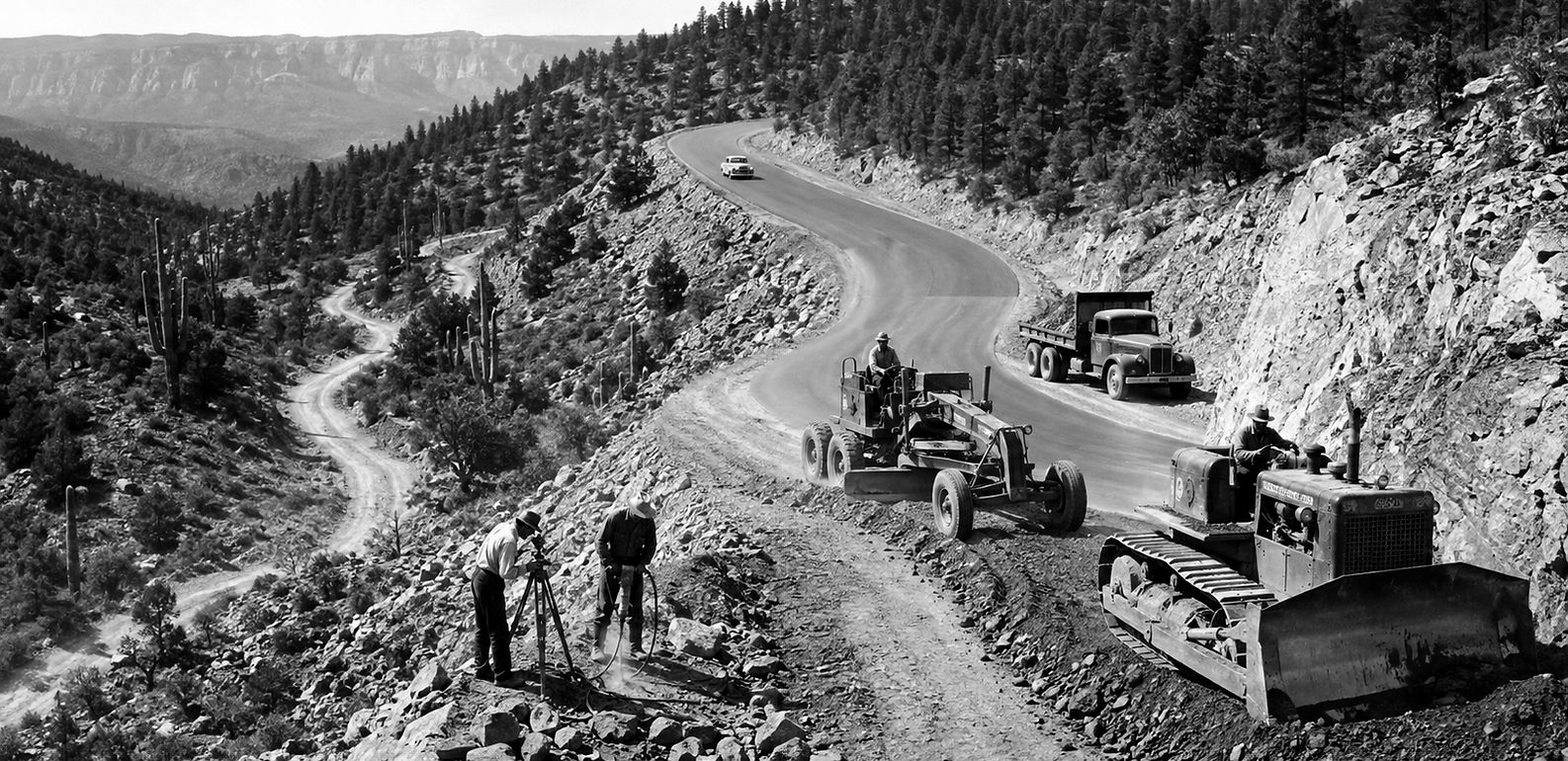
History of Highway 87 to Payson Highway 87—better known between Mesa and Payson as the Beeline Highway—developed from rough wagon trails into the road that transformed Payson from an isolated mountain community into an accessible part of Arizona. Crossing the Mazatzal Mountains was once extremely difficult. Around 1912, travelers from Mesa commonly followed the Apache Trail toward Roosevelt Dam before turning north through the Tonto Basin. Reaching Payson could take two days. Early mountain tracks were narrow, steep and sometimes ended entirely, forcing travelers to continue on foot or horseback. Arizona Highways In the early 1930s, Mesa lumberman Harvey Bush pushed for a more direct road to Payson. Federal funding was approved in 1933, and the original Bush Highway opened a route across the Mazatzal Mountains. It was an improvement, but still slow and dangerous. During the 1930s, driving from Phoenix to Payson could take nine to twelve hours. Beginning in 1939, portions were widened, compacted and treated with oil. The modern Bush Highway near Saguaro Lake is a surviving portion of this earlier route. During the early 1950s, Maricopa County Supervisor Jim Hart and regional business leaders began campaigning for a faster road. Hart helped secure a diagonal right-of-way through tribal lands between Mesa and the Saguaro Lake junction. Because this shortcut followed a more direct line toward Payson, people began calling it the Beeline Highway—a “beeline to the pines.” Construction crews straightened curves, installed bridges and moved the difficult section around Mount Ord westward through Slate Creek. Workers used jackhammers and dynamite to cut the highway through solid mountain rock. Some lived in an old mining settlement known as Goswick Camp. The Beeline remained largely gravel during the mid-1950s. Paving was eventually completed, and the ribbon was cut in Payson on July 19, 1958. It was the first fully paved highway across the mountains into Payson. Residents celebrated with a free community barbecue. By 1959, the State Route 87 designation had officially reached Payson and Strawberry. The new road dramatically increased tourism, construction and population growth. It also shifted much of the town’s commercial activity away from historic Main Street and toward the highway corridor. By 1968, State Route 87 had been extended northward over portions of former State Route 65. The completed route eventually connected central Arizona with Winslow and Second Mesa. North of Payson, Highway 87 climbs through Pine and Strawberry before reaching the Mogollon Rim. The original Beeline was a narrow, winding two-lane highway. It did not receive its first passing lane until roughly a decade after opening. Traffic increased rapidly, and serious accidents became a growing problem. Sections between Payson and the State Route 188 junction were improved during the late 1970s and early 1980s. From 1995 through 2001, approximately $170 million was spent rebuilding the highway between Mesa and State Route 188. The final bridge and realignment near Kitty Joe Canyon were completed in 2001, making the Mesa-to-Payson route a four-lane divided highway. In November 2003, the mountain route received the honorary designation Beeline Scenic Parkway. The journey that once required two days can now be completed from the Phoenix area in roughly 90 minutes. Highway 87 did more than shorten the drive—it permanently changed Payson’s economy, population and relationship with the rest of Arizona.
The Lake That Works Beneath the Surface The Creation of Green Valley Lake in Payson, Arizona Green Valley Lake was not created by damming a river or capturing a mountain stream. It was created because Payson needed to protect something far less visible—the water beneath the town. Although Payson is surrounded by pine forests and receives winter snow and summer rain, dependable water has always been one of the community’s greatest challenges. For much of its history, the town relied heavily upon underground wells. As Payson grew during the 1970s and 1980s, officials realized that the local aquifer might not be sufficient to support the community forever. Exploratory drilling produced mixed results. Some wells provided useful water, while others yielded far less than expected. Obtaining surface water from the surrounding national forest proved difficult, and years of work to secure additional water rights brought little immediate relief. At the same time, the Northern Gila County Sanitary District faced a different problem. In 1984, the district completed an advanced wastewater-treatment facility at American Gulch. The new plant produced highly treated reclaimed water, but Payson did not have a large storage facility where that water could be held for future use. Much of it continued downstream, carrying a potentially valuable resource away from the community that had produced it. By the late 1980s, the two problems began to look like parts of the same solution. Payson needed a way to strengthen its groundwater supply. The sanitary district needed somewhere to store and reuse its reclaimed water. In 1989, the Town of Payson and the Northern Gila County Sanitary District formed a partnership to create something Arizona communities rarely attempt: a water-reclamation system designed to function as a beautiful public park. The proposed project would be built at the western end of Main Street, on land donated by a local developer. Plans called for three connected lakes covering approximately twelve acres, surrounded by lawns, walking paths, picnic areas, restrooms, roads and a natural amphitheater. The lakes would provide recreation, but their most important work would take place underground. Highly treated reclaimed water would enter the lake system and slowly soak through the lake bottoms. This process, known as passive percolation, would return a portion of the water to the underground aquifer. Nearby monitoring wells would allow the town to measure changes in groundwater levels. Water stored in the lakes could also irrigate the park and other large landscaped areas around Payson, reducing the need to use drinking water on grass and trees. It was an ambitious idea. Residents were being asked to support much more than another public park. They were being asked to invest in the town’s future water supply. Payson voters approved a $4.5 million bond for the project. The sanitary district obtained an additional $1.5 million grant, and a $450,000 Arizona Heritage Fund grant helped support the recreational portions of the park. Construction began in 1994. Earth-moving equipment reshaped the open land at the end of Main Street. Crews excavated three lake basins, installed pipelines and pumps, built roads and created miles of walking paths. The upper lake was designed partly to collect sediment carried by storm runoff before the water moved through the rest of the system. The largest and deepest lake became the central feature of the park. As the basins began filling, the former construction site slowly changed. Bare ground became shoreline. Grass and young trees appeared. Walking paths followed the water’s edge, and the reflection of the surrounding hills replaced the dust of heavy machinery. On October 19, 1996, Green Valley Park was officially dedicated. That same month, the Arizona Game and Fish Department added the lakes to its community fishing program and stocked them with approximately 1,250 pounds of rainbow trout. A project originally created to address a serious water problem quickly became a place where parents taught children to fish, neighbors walked in the evening and families gathered for picnics beneath the Rim Country sky. Over time, Green Valley Park also became a home for Payson’s history and community traditions. Historic buildings, the Rim Country Museum and the replica Zane Grey Cabin joined the lakes. Concerts, festivals, memorials and Fourth of July celebrations brought thousands of people to the park. Most visitors see the fountains, ducks, fishing docks and changing reflections on the water. They may not realize that the lakes are still performing the work for which they were created. The water continues to support groundwater recharge. It irrigates the park and helps supply other large landscapes around town. Storm runoff can be temporarily stored in the lake system, while reclaimed water is preserved for productive use instead of simply flowing away. Green Valley Park is beautiful, but its beauty was never its only purpose. It represents a moment when Payson looked at two difficult problems and discovered that each could help solve the other. The town needed water. The sanitary district needed a place to store it. Together, they created a lake, a park and a lasting community gathering place. Most monuments rise above the ground so people can see them. Green Valley Lake quietly does its most important work below it.

The Day the Rim Echoed The Battle of Big Dry Wash North of Payson, beyond Pine and Strawberry, the Mogollon Rim breaks into a maze of forests, ridges and deep canyons. Today, the country near General Springs is peaceful enough that a person can hear wind passing through the ponderosa pines. On July 17, 1882, that silence was shattered by rifle fire. The Battle of Big Dry Wash became the last major battle fought in Arizona between United States troops and Apache warriors. It was not simply a fight between two clearly separated peoples. Tonto Apache scouts rode with the Army, while White Mountain Apache warriors waited across the canyon. Apache people stood on both sides of the battlefield, reflecting the painful divisions created during the reservation era. The battle grew out of decades of conflict, displacement and resistance. As American settlement expanded across Arizona Territory, Apache communities were forced onto reservations and subjected to military and government control. Conditions were harsh, freedom of movement was restricted and distrust existed on every side. In early July 1882, approximately sixty White Mountain Apache left the San Carlos Reservation under a young leader named Natiotish. The group acquired horses and ammunition and traveled north through central Arizona. During their journey, Apache police, ranchers and settlers were killed. Ranches were attacked and animals taken as the warriors moved past Globe, through Pleasant Valley and toward the East Verde River. Near what is now Whispering Pines, John Meadows was killed and his wounded son Henry later died. News of the attacks spread quickly through the isolated settlements of Rim Country. Families gathered inside the strongest available buildings, and riders carried warnings across the mountains. Army units were dispatched from several Arizona forts to find the group before it could disappear into the high country. Captain Adna Chaffee led Troop D of the 6th Cavalry from Camp McDowell. Traveling with him were veteran scout Al Sieber and a group of Tonto Apache scouts. Additional soldiers from the 3rd and 6th Cavalry approached from other directions. The pursuit was exhausting. There were few dependable roads, and the broken terrain forced horses and pack animals across steep slopes, rocky trails and nearly waterless country. The Apache group knew the mountains and moved rapidly toward the Mogollon Rim. After reaching the top, Natiotish selected a place to make a stand. Big Dry Wash was not a broad, sandy wash like its name might suggest. It was a deep branch of East Clear Creek, cutting through the forest like a tremendous wound in the earth. The canyon walls were steep, and the trail descended through a narrow crossing that could be covered by rifle fire from above. The Apache warriors constructed defensive positions from rocks and fallen logs. From their side of the canyon, they could see Chaffee’s mounted soldiers approaching. They believed the visible cavalry troop represented the entire force pursuing them. They intended to let the soldiers enter the crossing before opening fire. What they did not know was that additional cavalry units and Apache scouts had already joined the pursuit. They also underestimated Al Sieber’s ability to recognize an ambush. The scouts moved ahead of the soldiers and discovered the concealed positions before Chaffee’s men entered the trap. The cavalry dismounted, sent their horses to the rear and took cover among the trees. Accounts disagree about which side fired first, but gunfire soon crashed across the canyon. Rather than sending his men directly down the exposed trail, Chaffee held part of his force in front of the Apache positions while other units searched for places to cross the canyon. The soldiers in front maintained their fire, creating the impression that the Army was preparing a direct attack. Meanwhile, troops and Apache scouts moved around both sides. The descent was dangerous. Men climbed down broken canyon walls, crossed the bottom and struggled up the opposite side. By the time the flanking groups reached the plateau, they were positioned behind and beside the Apache defenses. The intended ambush had been reversed. As the soldiers and scouts advanced through the pine forest, the Apache warriors suddenly faced rifle fire from multiple directions. Their horses were captured, and the route toward the reservation was cut off. The battle became a series of close engagements fought among trees, rocks and shallow defensive positions. Smoke from black-powder rifles drifted through the forest. Several soldiers were badly wounded, including two officers. One cavalry private and one Apache scout fighting with the Army were killed. Natiotish and many of his warriors died during the fighting. Historical estimates vary, but between sixteen and twenty-seven Apache were killed. A count made after the battle reportedly located twenty-two bodies. As darkness approached, a violent mountain storm swept across the battlefield. Rain turned to hail, covering portions of the ground. Under the protection of darkness and the storm, the surviving Apache escaped through side canyons and continued toward the reservation. When the firing stopped, neither side could claim an ending free of suffering. The Army regarded Big Dry Wash as a military victory and the destruction of the last major Apache fighting force operating in central Arizona. For the Apache, it represented another devastating loss during a period in which their land, independence and traditional life had been steadily taken from them. The battle did not end every Apache conflict. Chiricahua Apache resistance continued in southern Arizona and Mexico until Geronimo’s final surrender in 1886. However, Big Dry Wash is generally recognized as the last major Army-Apache battle fought within Arizona. Decades later, the Forest Service and Civilian Conservation Corps erected a stone monument near the battlefield. It lists the soldiers and scouts who participated and marks a place where the quiet forest once became a battlefield. The monument stands north of Payson along the Rim Road near General Springs. Around it, the ponderosa pines have reclaimed the silence. But the history remains. The Battle of Big Dry Wash should not be remembered only as a cavalry victory or an Apache defeat. It should be remembered as a human tragedy shaped by violence, displacement, fear and resistance—a day when people on both sides entered the forest, and many never returned. The Rim still holds their story.

The Street That Held Payson Together Long before paved roads, traffic lights, and storefront signs, Payson’s Main Street was little more than a dusty path through Arizona’s mountain country. Wagons rolled across it carrying timber, mining equipment, sacks of flour, and supplies for distant ranches. Horses stood tied outside rough wooden buildings while neighbors traded news beneath the tall ponderosa pines. Main Street was not simply a road. It was where Payson learned to become a town. The settlement was still known as Green Valley when businessman Henry Sidles constructed a saloon and dance hall near what is now Main Street and Bootleg Alley in 1882. Across the road, merchant John Hise opened a store where ranch families, miners, and lumbermen could purchase the necessities that were difficult to produce at home. These businesses helped establish the center of the growing community. Travelers arriving from the south naturally followed the road toward them. Before long, the intersection became the place to find supplies, shelter, conversation, and occasionally a lively evening of music and dancing. When a post office was established in 1884, it operated from Hise’s store. The settlement received the name Payson, and Main Street became its connection to the outside world. Letters from relatives, government notices, newspapers, and business orders all passed through the small post office. For isolated families living miles beyond town, a visit to Main Street was an important occasion. They arrived with lists of needed supplies and often remained long after their shopping was complete, sharing stories and learning what had happened since their previous visit. During Payson’s early decades, Main Street could change with the weather. Summer traffic stirred clouds of dust between the buildings. Heavy rain transformed wagon ruts into channels of mud. In winter, snow sometimes softened the road and quieted the town. Yet the street remained busy. Cowboys rode in from surrounding ranches. Lumber workers came down from camps in the forest. Prospectors purchased tools and provisions before returning to the mountains. Wagons stopped near the mercantile, while horses were cared for at the livery stable. In 1889, August and Wilhelmina Pieper purchased Sidles’s business and expanded the operation with a mercantile and livery stable. The Pieper building became another familiar gathering place on Main Street, serving both local residents and travelers passing through the region. Business was only one part of the street’s importance. Main Street also served as Payson’s public gathering ground. Community celebrations, dances, rodeo activities, and the famous August Doin’s brought crowds into town. During these events, the ordinary dirt road could become a parade route, meeting place, and open-air grandstand. For a few days, Main Street belonged to everyone. By the early 1930s, Payson was still a small and relatively isolated mountain community. The journey from Phoenix could take most of a day over rough and winding roads. Visitors who reached town needed a place to eat, rest, and hear the latest local stories. William and Estelee Wade answered that need by constructing the Payson Hotel in 1932 and 1933. Built with ponderosa logs from a local mill and accented with native red sandstone, the building reflected the materials and character of the surrounding country. The hotel stood beside the Busy Bee restaurant and near Randall’s Garage. Its upstairs rooms offered lodging, while the ground floor included a lobby, dining area, and bar. A balcony faced Main Street, giving guests a fine view of parades, rodeo celebrations, and the daily activity below. From that balcony, a visitor could watch nearly every part of Payson life pass by: ranch wagons, riders, timber workers, children, merchants, and travelers shaking dust from their clothes after the long trip into town. In 1945, Jimmy Cox purchased the hotel and expanded it into the neighboring garage. The combined property became the Ox Bow Inn, with a distinctive Western-style appearance that suited Payson’s ranching identity. The Ox Bow became one of Main Street’s best-known social landmarks. It offered food, lodging, drinks, music, and dancing. Residents gathered there after work, visitors heard stories about the surrounding Rim Country, and celebrations continued late into the evening. Although Payson was changing, Main Street remained its social heart. The street was still unpaved in the mid-1940s, and the mixture of log buildings, saloons, garages, stores, and horses gave it the appearance of a Western town that had grown naturally rather than according to a carefully drawn plan. Every building seemed to carry a different chapter of the community’s story. For many years, reaching Payson from the Valley required a slow journey along the Bush Highway and mountain roads. That changed with the completion of the Beeline Highway in 1958. The new highway dramatically shortened the trip between Phoenix and Payson. More visitors could reach the Rim Country, and the town began to grow rapidly. New businesses appeared along the highway, following the steady stream of automobiles. But the Beeline did not pass directly along old Main Street. Traffic that once rolled past the hotel, mercantile, and saloons was drawn toward the new commercial corridor. Payson’s center of activity gradually shifted east. Main Street became quieter, and some of its older buildings disappeared or found new purposes. The change might have erased the street’s importance. Instead, it revealed something deeper: Main Street mattered for more than the traffic it carried. Today, Payson’s Main Street Historic District preserves part of the town’s ranching, logging, and frontier heritage. Old cabins and commercial buildings now stand beside newer businesses. The Pieper building and the Ox Bow property remain physical reminders of the people who worked, celebrated, and built their lives there. Modern visitors may no longer arrive by wagon, and the street is no longer covered in dust. Yet its history can still be found in the logs of an old building, the shape of a weathered doorway, or the quiet space where horses once waited beside a mercantile. Highway 87 carries travelers through Payson. Main Street carries the memory of Payson. Before the town had paved avenues, shopping centers, or a modern highway, this was where people collected their mail, purchased their supplies, danced with their neighbors, welcomed strangers, and watched the community grow. Before Payson had a downtown, Main Street was the town.

Before Payson: The Native People of Rim Country Long before Payson had streets, ranches, mines, or sawmills, Native people knew the surrounding mountains by their springs, plants, animals, trails, and stories. The Mogollon Rim, Mazatzal Mountains, Sierra Ancha, East Verde River, Tonto Creek, and Fossil Creek were not an empty wilderness waiting to be discovered. They were part of a living homeland—a landscape that provided food, water, medicine, shelter, and places of deep cultural and spiritual importance. The history of Payson did not begin when settlers arrived in the nineteenth century. It began thousands of years earlier. Archaeological evidence shows that people have lived throughout central Arizona for many thousands of years. Ancient communities hunted game, gathered native plants, cultivated crops, and established settlements near reliable water sources. Different archaeological traditions are associated with the greater region, including people now described by researchers as Hohokam, Mogollon, and Salado. These are modern archaeological classifications, not necessarily the names the people used for themselves. They left behind pottery, stone tools, agricultural features, rock markings, and the remains of dwellings. These physical traces reveal only part of their story. Much of their knowledge, identity, and understanding of the land was carried through oral traditions rather than written records. Centuries later, when American settlers entered Rim Country, the area was part of the homelands of the Western Apache and Yavapai peoples. The Native community most closely connected with present-day Payson is the Tonto Apache Tribe. The people also identify as Dilzhé’é and are part of the larger Western Apache cultural and linguistic family. According to the Inter Tribal Council of Arizona, Payson was originally known as **Te-go-suk**, translated as “Place of the Yellow Water.” The name reflects an understanding of the landscape that existed long before the community became Green Valley, Union Park, or Payson. The Tonto Apache lived throughout the mountains, valleys, and creek country surrounding the present town. Rather than depending upon one permanent settlement, families moved through familiar territories according to the seasons and the availability of food and water. They hunted deer and other game, gathered berries, seeds, roots, and useful plants, and cultivated crops in places where soil and water allowed. Emory oak acorns were—and remain—an important Indigenous food source in Arizona. Harvesting, preparing, and sharing them required knowledge passed carefully from one generation to the next. The land was more than a collection of resources. Mountains, springs, plants, and animals were connected to identity, responsibility, and spiritual life. The history of central Arizona also includes the Yavapai people. Western Apache and Yavapai families lived in neighboring and sometimes overlapping territories, particularly around the Verde Valley, Fossil Creek, and the Mazatzal Mountains. Although they were culturally and linguistically distinct peoples, Apache and Yavapai communities sometimes lived near one another, traded, formed family relationships, and shared knowledge of the country. Outsiders frequently confused the two groups or applied the same names to both, obscuring important differences in their identities. Fossil Creek illustrates their enduring connection to Rim Country. Archaeological evidence indicates Native use of the area extending back thousands of years. The creek later became an especially important place for Western Apache and Yavapai communities. The Apache name **Tu’dotłiz**, meaning “blue water,” reflects the creek’s remarkable color, waterfalls, and vegetation. Today, Fossil Creek continues to hold profound cultural and religious importance for Apache and Yavapai people. During the nineteenth century, miners, ranchers, soldiers, and settlers began moving into central Arizona in increasing numbers. They claimed water sources, grazing lands, timber, and places Native families had used for generations. Competition over land and resources grew into violence. The United States military conducted campaigns against Apache and Yavapai communities throughout the region. Native families faced attacks, confinement, hunger, and pressure to abandon their homelands. In 1871, the federal government established the Rio Verde Reserve near present-day Camp Verde for Tonto Apache and Yavapai people. Despite their efforts to build farms and establish a self-supporting community, the government dissolved the reserve in 1875. The people were forcibly removed to the San Carlos Apache Reservation. They were compelled to travel across difficult country during winter, far from the lands they knew. Families suffered from hunger, exposure, disease, and death. The removal separated people from familiar hunting grounds, farms, sacred places, and relatives. It was not a voluntary migration. It was an exile imposed by the federal government. Some Tonto Apache eventually began returning to the Payson area after approximately twenty years away. They returned to familiar mountains and water sources, but the community they encountered had changed. Settlers had occupied much of their former homeland. Fences crossed places that had once been open. Ranches, mines, roads, and businesses stood where Native families had previously traveled, gathered food, and established seasonal camps. The returning families possessed little land and few legal protections. Some lived in an area near Payson commonly known simply as “the Camp.” Tribal members worked where employment was available while maintaining family connections, cultural knowledge, and ties to the surrounding country. Other Apache and Yavapai families returned to places along the Verde River and Fossil Creek. Some worked on the construction and maintenance of the Childs-Irving hydroelectric system during the early twentieth century. Others farmed along the creek or established homes near traditional areas. Their return was not a restoration of everything that had been taken. It was an act of survival. For decades, the Tonto Apache remained a Native community with only a tiny land base beside a growing non-Native town. After years of persistence, the Tribe eventually secured a reservation adjacent to Payson. The Tonto Apache Reservation consists of approximately 85 acres, making it the smallest reservation land base in Arizona. Its size stands in sharp contrast to the broad territory the people traditionally knew and used. Despite that limitation, the Tribe has created a permanent center for its community. Tribal government, businesses, employment, cultural traditions, and family life continue there today. Tonto Apache artists are particularly respected for beadwork and basketry. These arts are not simply decorations from a vanished past. They represent living skills, creativity, identity, and knowledge carried forward by contemporary Native people. The Tribe is also an important part of the modern Payson community and local economy. Its presence is not merely historical. Tonto Apache people remain neighbors, business owners, artists, employees, leaders, parents, elders, and children. It is tempting to tell Native history as if it ended when settlers arrived. That version leaves the most important part of the story unfinished. The Tonto Apache survived forced removal, dispossession, and decades without an adequate homeland. Apache and Yavapai people maintained relationships with places such as Fossil Creek even when government policies attempted to separate them from those lands. Their cultures did not disappear. Their connection to Rim Country continues. Every history of Payson should therefore begin with a simple recognition: the town stands within an Indigenous homeland whose story is far older than the town itself. The forests were known before they were mapped. The creeks had names before they appeared on government surveys. Trails crossed the mountains before wagons and automobiles arrived. Generations of Native families understood how to live within this demanding landscape long before newcomers called it Arizona. Payson’s Native history is not only a story about what was lost. It is also a story of return, endurance, cultural strength, and survival. The Tonto Apache people are not a vanished chapter in the history of Rim Country. They are part of its beginning, its present, and its future.

The Forts Around Payson: Outposts on a Changing Frontier Visitors sometimes imagine that a large wooden fort once stood in the center of Payson, protecting a frontier settlement behind tall walls. The real history is more complicated. No major permanent Army fort was constructed within present-day Payson. Instead, the community developed near a network of military camps, wagon roads, and outposts surrounding Rim Country. Camp Reno, Fort McDowell, Fort Verde, and Fort Apache helped the United States Army move soldiers and supplies through the mountains during the conflicts commonly called the Apache Wars. These posts were established before Payson officially became a town. Their roads opened previously isolated country to miners, ranchers, merchants, and settlers—but their military campaigns also resulted in violence, displacement, and the forced removal of Native people from their homelands. The forts around Payson therefore tell two connected stories: the expansion of territorial Arizona and the struggle of the Apache and Yavapai people to remain on their ancestral lands. During the 1860s, central Arizona was one of the territory’s most difficult regions to cross. The Mazatzal Mountains, Sierra Ancha, Tonto Basin, and Mogollon Rim were divided by steep canyons, rocky slopes, and unpredictable waterways. The Tonto Apache and Yavapai knew this country intimately. Their trails connected springs, camps, hunting areas, farms, gathering places, and locations of cultural importance. Newcomers did not possess that same knowledge. When miners and ranchers began entering the region, the United States Army faced a serious transportation problem. Soldiers could not operate for long without food, ammunition, replacement horses, medical supplies, and reliable communication. Wagons needed roads wide enough to cross the mountains, and military units required outposts where men and animals could rest. A chain of Army posts was created around central Arizona. Payson would eventually develop near the center of that military network. Fort McDowell was established in 1865 near the meeting of the Verde and Salt rivers, southwest of present-day Payson. It became one of the Army’s most important bases for operations into the mountains and Tonto Basin. The fort included barracks, officers’ quarters, storage buildings, corrals, workshops, and other facilities needed to support soldiers in an isolated region. It did not resemble the massive stone castles of Europe. Like many Western military posts, it was a practical collection of buildings constructed from locally available materials. From Fort McDowell, soldiers built and followed routes into the Mazatzal Mountains. Patrols searched for Apache and Yavapai groups while military escorts attempted to protect supply routes, settlers, ranches, and mining operations. The fort’s location allowed the Army to move north and east into Rim Country. However, the mountains made every mile difficult. This led to the creation of a smaller outpost closer to Tonto Creek. Camp Reno was established in 1867 as an outpost of Fort McDowell. Located near Tonto Creek on the western side of the Tonto Basin, it was the military post most directly connected to the country surrounding future Payson. Soldiers worked to construct a wagon road from Fort McDowell through the Mazatzal Mountains. The route climbed rugged slopes, crossed Reno Pass, and descended toward the basin. Building it required clearing vegetation, moving rock, widening narrow trails, and finding grades that heavily loaded wagons could manage. Camp Reno was a small and temporary post. Its buildings were made primarily from adobe, stone, timber, and other materials available nearby. The camp reportedly included barracks, officers’ quarters, storage areas, a bakery, and facilities for horses and mules. Life there was isolated and uncomfortable. Summer heat rose from the basin, while winter weather could make mountain travel dangerous. Supplies arrived slowly, equipment broke, and water had to be carefully managed. From Camp Reno, soldiers conducted patrols through Tonto Basin and the surrounding mountains. The post supported military operations against Tonto Apache and other Native groups defending or moving through their traditional territory. Camp Reno lasted only a few years and was abandoned in 1870. Its short life demonstrated how expensive and difficult it was to maintain a remote military outpost in Arizona’s mountain country. Today, only faint ruins and scattered traces remain. Northwest of Payson, another military presence developed beside the Verde River. Early camps were established there beginning in the mid-1860s, eventually becoming Fort Verde. Fort Verde served as an important base for Army campaigns during the 1870s and 1880s. Soldiers, officers, doctors, civilian employees, family members, and Native scouts all lived or worked at the post. The fort helped protect settlers and agricultural operations in the Verde Valley. It also became part of the federal government’s effort to confine Apache and Yavapai people to reservations. In 1871, the Rio Verde Reserve was established near Camp Verde. Tonto Apache and Yavapai families built irrigation systems, cultivated crops, and worked to create a self-supporting community there. Despite those efforts, the federal government closed the reserve in 1875. Its residents were forced to travel to the San Carlos Apache Reservation, far from their homes. Many suffered from hunger, sickness, exposure, and death during and after the removal. Fort Verde remained in operation until 1891. Four original buildings survive today as part of Fort Verde State Historic Park, preserving one of Arizona’s best remaining examples of an Indian Wars-era military post. Farther east, near the headwaters of the Salt River, the Army established a temporary post in 1870. It was known by several names before eventually becoming Fort Apache. Fort Apache helped extend military control across eastern Arizona. Roads and supply routes connected it with other posts, allowing troops to move between the White Mountains, Verde Valley, Tonto Basin, and settlements such as Globe. The fort also became associated with Apache Scouts—Native men who served with the United States Army. Their reasons for enlisting were complex. Some sought wages, food, protection for their families, or advantages in conflicts with rival groups. Others used their position to remain near their homelands or to navigate a world being dramatically changed by federal power. The scouts’ knowledge of trails, water sources, weather, and mountain terrain was invaluable to the Army. Their service is an important reminder that the history of the frontier was rarely divided into two simple sides. Fort Apache is now located within the Fort Apache Indian Reservation. Its preserved buildings and grounds are interpreted through the Fort Apache Historic Park and the White Mountain Apache Tribe’s cultural center. Although most of the military posts were eventually abandoned, the routes connecting them did not simply disappear. Army wagon roads became pathways for miners, ranchers, mail carriers, merchants, and settlers. These routes increased travel between the Verde Valley, Tonto Basin, Globe, and the mountain valley that became Payson. When gold prospectors entered the Payson area around 1880, they followed a country that military expeditions had already begun mapping and crossing. Merchants used improved routes to bring in food and equipment. Ranchers drove livestock along trails that connected isolated settlements with larger markets. In this way, the forts influenced Payson without standing inside it. The military network made sustained non-Native settlement more practical while the removal of Apache and Yavapai communities opened their traditional lands to newcomers. That expansion came at an enormous cost to the people who had lived in Rim Country for generations. By the time Payson was formally named in 1884, Camp Reno had already been abandoned. Fort McDowell, Fort Verde, and Fort Apache remained active, but their military importance gradually declined as Native resistance was suppressed and more land was placed under federal control. Payson grew as a ranching, mining, logging, and supply community rather than a military town. There was no central parade ground, no permanent garrison, and no large fort overlooking Main Street. Nevertheless, soldiers, scouts, wagon roads, and military campaigns had already shaped the region in which the new town developed. The forts had changed who could move through the country, who controlled its roads and water, and who was permitted to live upon the land. Today, the remains of Camp Reno are faint and fragile. Fort Verde preserves several original buildings, while Fort Apache contains a larger historic district. The original Fort McDowell military post is gone, but its name continues through the Fort McDowell Yavapai Nation, whose people maintain an enduring connection to central Arizona. These places should not be remembered only as symbols of frontier adventure. For soldiers, the forts were isolated assignments in a harsh and unfamiliar landscape. For settlers, they offered a measure of protection and opened transportation routes. For Apache and Yavapai people, they represented the military force used to occupy their homelands, restrict their movement, and remove families to distant reservations. All of those experiences belong in the history. Payson never had a great fort of its own. Instead, it arose among the roads and consequences left by the forts surrounding Rim Country. The buildings have mostly vanished, but the routes they opened—and the changes they brought—remain part of Payson’s story.

Gold in the Rim Country: The Mining Story of Payson Before Payson became known for pine forests, rodeos, and mountain recreation, men came to the surrounding hills carrying picks, shovels, and the hope of finding gold. They searched the canyons, creek beds, and rocky slopes around what was then called Green Valley. Some were experienced miners who understood the difficult work ahead. Others were dreamers who believed one shining piece of quartz might lead them to a fortune. Together, they helped establish one of the earliest industries in the Payson area. Prospectors began exploring the Payson–Green Valley Mining District during 1875 and 1876. Their attention was drawn to pieces of loose rock containing visible gold. Finding gold-bearing rock on the surface suggested that richer deposits might be hidden somewhere beneath the surrounding hills. The discovery created excitement, but mining around Payson was never easy. Much of the gold was locked inside solid rock rather than concentrated in shallow stream deposits. A prospector could not simply stand beside a creek and wash away sand until gold remained in the bottom of a pan. He often had to locate a mineralized vein, dig into the mountain, remove heavy ore, and somehow transport it to a place where it could be crushed and processed. Every step required money, equipment, labor, and determination. By approximately 1880, increasing numbers of miners and prospectors were moving through the Rim Country. Pack animals and wagons carried tools, food, timber, blasting supplies, and machinery over rough roads from communities such as Globe. The activity helped bring settlers and commerce into Green Valley. Miners needed meals, lodging, lumber, horses, blacksmithing, and supplies. Merchants established stores, ranchers provided meat and produce, and sawmills supplied timbers used to support underground workings. Although ranching and logging eventually became more dependable parts of the local economy, mining helped create the demand that allowed the early settlement to grow. A mining camp might disappear when its ore ran out, but Payson began developing into something more permanent—a community that could serve the scattered mines, ranches, and timber camps throughout the surrounding country. One of the best-known mining properties near Payson was the Ox Bow Mine. The claim was reportedly located in 1876 by Al Sieber, William Moore, and a man identified in historical accounts as St. John. Like many Arizona mining properties, the Ox Bow experienced periods of activity followed by long periods of silence. Owners and investors came and went. Tunnels were driven into the rock, ore was removed, and plans were made for larger operations. When money became scarce or the ore failed to meet expectations, the work slowed or stopped. The mine received renewed attention during World War I, when demand for metals encouraged mining throughout Arizona. Supplies still had to be hauled across difficult country, while timbers needed for the mine came from sawmills east of Payson. Below Ox Bow Hill, miners occasionally searched for placer gold after seasonal rains. Water was precious in the region, and small-scale placer work was most practical when storms provided enough runoff to wash gravel. The results were generally limited, but even a small amount of gold was enough to keep hope alive. The Ox Bow name later became familiar in town through the Ox Bow Inn on Main Street, although the inn and the mine were separate parts of Payson’s history. Another prominent property was the Golden Wonder Mine, located around 1877. Its name reflected the optimism common throughout the district. Mining claims were frequently given memorable names that spoke of fortune, rescue, independence, or discovery. Across the Payson district, miners explored veins containing gold and copper. Some claims developed into producing mines, while others remained little more than shallow shafts, trenches, and hopeful names written on paperwork. The Gowan Mine, discovered around 1880, became another part of the area’s mining story. Like the Ox Bow and Golden Wonder, it represented the persistent belief that valuable deposits remained hidden in the mountains. For every mine remembered by name, there were many smaller prospects. A man might spend weeks following a narrow vein only to see it disappear. Another might uncover promising ore but lack the money to develop it. Some prospectors sold their claims to investors, while others continued working alone with little more than hand tools and stubborn determination. Mining was dangerous and exhausting work. A miner entered a dark tunnel illuminated by a candle or oil lamp. He swung a hammer in cramped spaces, drilled holes into solid rock, and used explosives to break the ore loose. Falling rock, bad air, unstable timbers, and accidental explosions were constant dangers. Outside the mine, conditions were not much easier. Machinery broke down, roads washed out, and winter storms made transportation difficult. Water needed for processing ore was often limited. Food, tools, and replacement parts might be many miles away. Even after valuable ore was removed, it still had to be crushed and processed. Small milling operations depended on reliable machinery and an adequate water supply. Ore that appeared rich at the mine could prove disappointing after processing costs were considered. A mine did not need to be empty to fail. It only needed to cost more to operate than the recovered metal was worth. The Payson district never became a mining center on the scale of Globe, Jerome, or Bisbee. There was no single discovery that transformed the community into a large boomtown. Instead, mining around Payson followed a cycle familiar across the West: discovery, excitement, investment, hard work, disappointment, and eventual rediscovery by a new generation of hopeful miners. Yet the importance of mining cannot be measured only by the amount of gold produced. Mining brought people into the region and increased travel between Payson, Globe, and the Tonto Basin. It created business for merchants, freighters, ranchers, blacksmiths, and sawmills. It encouraged the construction of roads and trails through country that had once been extremely isolated. Most importantly, it helped sustain the settlement during its earliest years. The old mines surrounding Payson are quiet today. Some entrances have collapsed, while others have been closed for public safety. Scattered pieces of equipment, rock piles, and weathered foundations still mark places where people once worked beneath the Arizona sun. These abandoned sites should never be entered. Old shafts can be concealed by vegetation or unstable ground, and tunnels may contain dangerous air, loose rock, wildlife, and rotting support timbers. Removing minerals or artifacts may also be prohibited depending on land ownership and mining-claim status. The safest place to explore this chapter of local history is through museums, historical records, and marked public sites. The miners who came to Green Valley did not create the great gold empire many imagined. Most never became wealthy. Some departed with empty pockets, while others remained and became ranchers, merchants, lumbermen, or permanent members of the community. Their greatest discovery may not have been gold at all. It was a mountain valley where roads, businesses, homes, and friendships could take root. The mines gave people a reason to come, but the community gave them a reason to stay. Payson was not built upon one great fortune buried in the earth. It was built by generations of people willing to search, work, struggle, and begin again.

Gunfire in Rim Country: The Truth Behind Payson’s Shootout Stories The history of Payson is filled with cowboys, saloons, isolated ranches, and men who regularly carried firearms. It sounds like the perfect setting for a famous Old West shootout. Yet unlike Tombstone, Payson does not have one thoroughly documented gunfight in which celebrated lawmen faced a band of outlaws in the middle of Main Street. There are stories of saloon violence, armed confrontations, and gunfire, but many were preserved through oral history rather than detailed court records or newspapers. The most serious violence occurred beyond town, where Payson stood in the shadow of one of the deadliest range feuds in the American West—the Pleasant Valley War. The true story is less polished than a Western movie. There were few honorable duels and no guarantee that the person wearing a badge was the hero. Most victims were attacked unexpectedly, and many killings were never solved. During Payson’s early years, law enforcement was limited and help could be hours—or days—away. Ranchers carried firearms to protect themselves and their livestock in isolated country. Travelers were responsible for their own safety. Miners transported valuable equipment and occasionally gold or silver. Cowboys arriving in town were often armed because carrying a weapon was an ordinary part of working far from settled communities. Main Street became the place where these people came together. Payson’s first saloon and dance hall was constructed in 1882 near what is now Main Street and Bootleg Alley. Additional drinking establishments followed as the town grew. The saloons served important purposes: they were places to hear news, conduct business, find lodging, attend dances, and escape the isolation of ranch life. They could also become dangerous when alcohol, personal grudges, and loaded weapons entered the same room. Most evenings ended without bloodshed. Nevertheless, arguments, fistfights, property damage, and occasional gun violence became part of Payson’s frontier reputation. One of Payson’s best-known drinking establishments was the 16-to-1 Saloon, built in 1899 by blacksmith James C. Callaghan. It stood near the location later associated with the Ox Bow Inn. Its unusual name came from a national political battle over money. Western miners supported valuing silver at a ratio of 16 ounces of silver to one ounce of gold. The phrase “16 to 1” became a rallying cry in mining communities. Inside the Payson saloon, customers drank, played billiards, exchanged stories, and celebrated after long weeks on ranches or in mining camps. Oral histories preserved by the Rim Country Museum describe occasional violence when cowboys drank too heavily. The saloon’s most famous disturbance involved a local man named Bill Wilbanks. According to an account given by Theresa Boardman, Wilbanks had an old bullet lodged in his head. When he became drunk, townspeople feared his unpredictable behavior. A warning reportedly traveled through Payson whenever he arrived in that condition: Wilbanks was coming, and people should take cover. During one destructive episode, Wilbanks tore apart the 16-to-1. He threw chairs and billiard balls into a well, smashed furniture, and broke the saloon’s large front windows. Local men eventually restrained him, and a doctor gave him a sedative. The incident was not a dramatic exchange of gunfire, but it illustrates how quickly disorder could overwhelm a small community with limited law enforcement. Wilbanks cut his thumb during the destruction. The wound reportedly became infected, and he died several days later from blood poisoning. The badly damaged saloon never reopened. While Payson experienced occasional saloon disturbances, a far more dangerous conflict was spreading through Pleasant Valley, approximately 50 miles east of town. The Pleasant Valley War—also called the Tonto Basin Feud or the Graham-Tewksbury Feud—lasted roughly from 1882 until 1892. Its causes included accusations of cattle theft, disputes over grazing land, personal rivalries, economic competition, and the arrival of sheep in cattle country. The conflict began with disagreements between ranching families and their allies. It soon drew in cattle companies, sheep owners, cowboys, hired gunmen, law officers, and vigilantes. Revenge became its own justification. A stolen animal led to an accusation. An accusation led to a confrontation. A shooting led to retaliation. After several years, people were being killed for supporting the wrong family, providing information, or simply being suspected of taking sides. Estimates of the dead vary, partly because some victims disappeared in remote country and many murders were never officially connected to the feud. One of the feud’s most notorious confrontations occurred at the Tewksbury ranch in Pleasant Valley in September 1887. Members of the Graham faction concealed themselves near the property. When John Tewksbury Jr. and William Jacobs went outside to gather horses, both men were ambushed and killed. Gunfire was then exchanged between the attackers and people inside the cabin. The confrontation continued for hours. Later retellings added dramatic details, and historians disagree about portions of the story. What remains clear is that this was not an arranged duel between willing opponents. It was an ambush followed by a prolonged attack on an occupied home. That distinction matters. The violence of Rim Country was often personal, hidden, and terrifying—not the clean quick-draw contest later presented in movies. Several days later, the feud produced one of Arizona’s most famous law-enforcement shootings—but it happened in Holbrook, not Payson. Apache County Sheriff Commodore Perry Owens went to the Blevins home to serve a warrant on Andy Blevins, also known as Andy Cooper. A gunfight erupted outside the house. In less than a minute, Owens killed Andy Blevins, Mose Roberts, and 15-year-old Sam Houston Blevins. John Blevins was wounded. Owens survived without being struck. The encounter made Owens a frontier legend, but it also demonstrated how the Pleasant Valley War spread far beyond the valley itself. The feud reached ranches, towns, courtrooms, and trails across territorial Arizona. The shooting intensified the cycle of retaliation rather than bringing it to an end. Payson was not the central battlefield of the Pleasant Valley War, but it was part of the same Rim Country world. Residents traveled between Payson, Pleasant Valley, Globe, Holbrook, and the Tonto Basin. News of killings moved through ranches and saloons. Families had to consider friendships, business relationships, and perceived loyalties carefully. In a small community, neutrality was difficult. Selling supplies to someone, offering a meal, repeating a rumor, or allowing a rider to sleep in a barn could be interpreted as choosing a side. The feud damaged more than its direct victims. It created years of fear, suspicion, and grief. People became accustomed to watching the trails and wondering whether an approaching rider carried news, a warrant, or a weapon. Research conducted through Arizona State University has examined the psychological toll of living under this constant threat. The violence affected survivors long after the last shots were fired. As decades passed, stories of Rim Country violence became part of local folklore. Details changed as accounts were repeated. Ordinary confrontations became gunfights, gunfights became great battles, and men with complicated histories became either heroes or villains. The image of two gunfighters stepping into a dusty street makes a memorable story. The historical record reveals something harsher. Most frontier killings were not fair fights. They were ambushes, revenge attacks, domestic disputes, drunken confrontations, or attempts to serve warrants. They left widows, children, frightened witnesses, and communities divided by loyalty and fear. Payson’s Old West history does include guns, saloons, and violence. But its real story is not about celebrating the fastest shooter. It is about a small mountain community trying to establish order in an isolated region where the law was distant, rumors were dangerous, and one act of revenge could lead to another. The gunfire eventually faded. Payson survived because most of its residents chose something more lasting than violence: families, businesses, ranches, churches, schools, and a community strong enough to outlive the feuds surrounding it.

When the Water Comes: The Flood History of Payson Most of the year, the creeks and washes surrounding Payson appear peaceful. Some are reduced to narrow streams moving beneath cottonwoods and sycamores. Others become dry channels filled with sand, rounded stones, and fallen branches. During Arizona’s summer monsoon, that quiet can change in minutes. Rain falling high on the Mogollon Rim collects in steep canyons and races toward lower ground. A dry wash can become a violent river before the storm is visible from the place where the flood arrives. For generations, people living in Rim Country have learned the same lesson: never mistake still water—or a dry creek bed—for permanent safety. Payson stands approximately 5,000 feet above sea level in Arizona’s mountainous transition zone. The Mogollon Rim rises to the north, while the Mazatzal Mountains and Tonto Basin stretch to the south. The elevation changes sharply across the region. Water falling on high ground is funneled into narrow drainages such as Ellison Creek, Christopher Creek, Tonto Creek, Sycamore Creek, and the East Verde River. These streams give life to Rim Country. Native people relied upon them long before Payson existed. Later ranchers used them to water livestock, farmers planted near them, and settlers established homes where springs and creeks offered a dependable supply. But the same channels that sustained life could also become dangerous. Early residents crossed rivers without modern bridges, paved approaches, or electronic warnings. A wagon might pass safely in the morning and find the return route blocked by afternoon. Livestock could be stranded on the opposite bank, while fences, tools, and equipment disappeared downstream. Flood stories became part of local knowledge. People watched the clouds over the Rim, listened for changes in the sound of a creek, and understood that rain did not have to fall directly overhead to create danger. Early summer in Payson is often hot, dry, and dusty. Then moisture begins moving into Arizona, bringing the thunderstorms of the North American Monsoon. Dark clouds rise above the mountains. Thunder echoes through the canyons. Rain may fall with extraordinary intensity over a small area while nearby communities receive almost nothing. This uneven pattern is one reason flash floods are so dangerous. A person standing beside a creek may see only light rain or even patches of blue sky. Several miles upstream, however, a severe storm may be releasing tremendous amounts of water into the same drainage. Steep slopes accelerate the runoff. Narrow canyons concentrate it. Loose soil, branches, boulders, and logs become part of the moving flood. The first warning may not be rain. It may be a distant roar. In September 1970, powerful storms struck parts of Arizona, Utah, Colorado, and New Mexico. Central Arizona received intense rainfall that produced sudden flooding in the watersheds of Tonto Creek, Sycamore Creek, and the East Verde River. These were waterways familiar to Payson-area residents, but familiar streams became powerful torrents as water poured from the surrounding mountains. Floods damaged roads, crossings, ranch property, and stream channels across the region. Even when Payson’s town center escaped the worst destruction, residents could be isolated when surrounding roads and river crossings became impassable. Such storms demonstrated that Payson’s flood history could not be measured only by water entering buildings within town. A flood miles away could cut transportation routes, endanger travelers, damage ranches, interrupt supplies, and leave communities separated from emergency assistance. The floods also showed how quickly ordinary rainfall could become a regional emergency when several mountain watersheds responded at once. Wildfire and flooding are closely connected in Rim Country. A healthy forest floor contains grasses, plants, fallen needles, roots, and soil that help slow rainfall and absorb water. After an intense wildfire, much of that protection may be gone. Severely burned soil can repel water rather than absorb it. Rain runs rapidly across the surface, carrying ash, loose earth, rocks, and burned timber into the drainage below. This mixture is more than muddy water. It can become a debris flow with enough force to move boulders, break trees, damage roads, and overwhelm anyone trapped in its path. The danger can remain long after the smoke disappears. A wildfire may be contained, yet the burn scar can continue producing increased runoff during later storms. That combination of fire, steep terrain, and monsoon rain led to the most tragic flood in Payson’s recent history. On July 15, 2017, an extended family was spending the afternoon at the Cold Springs swimming hole on Ellison Creek, north of Payson and near the East Verde River. The area was popular for its cool water and rocky pools. Conditions at the swimming hole did not reveal the full danger developing upstream. At 1:19 p.m., rain began falling over the fresh Highline Fire burn scar. The storm moved slowly across the upper drainage, following the direction in which water would eventually flow. Rainfall rates became extreme. National Weather Service estimates indicated that rain was falling at instantaneous rates of approximately 4.5 to 6.5 inches per hour during part of the storm. Roughly one inch fell in about 15 minutes over portions of the burn scar. By approximately 2:14 p.m., an estimated 1 to 1.5 inches had fallen across much of the affected area, with higher amounts in portions of the drainage. Near Cold Springs, however, only about half an inch had fallen. That difference was critical. The people downstream could not judge their danger by the rain around them. Water rushed from the burned slopes into Ellison Creek. The flood gathered mud, ash, rocks, branches, and logs as it traveled downstream. At approximately 3:30 p.m., the first flash-flood report was received near the meeting of Ellison Creek and the East Verde River. An estimated five-foot flood wave entered the Cold Springs swimming hole. Fourteen members of the family were caught in the surge. Ten people lost their lives. The tragedy became widely known as the Payson or Water Wheel flash flood, although the fatal impact occurred at Cold Springs on Ellison Creek. Significant debris also accumulated along the East Verde River near the Water Wheel Day Use Area. The event remains one of the most painful moments in the modern history of Rim Country. Emergency dispatchers, law-enforcement officers, firefighters, search-and-rescue volunteers, medical personnel, and community members responded to the flooding. The terrain made the operation difficult. Muddy water, debris, unstable banks, and limited access complicated rescue and recovery efforts. The search continued as families and residents waited for news. The tragedy affected people far beyond those present at the creek. Payson and surrounding communities grieved with the victims’ relatives. Residents who had visited the same swimming holes recognized how easily another family could have been caught in similar circumstances. Warnings about monsoon flooding took on a more personal meaning. The disaster also increased public understanding of burn-scar flooding. A storm did not need to be unusually large across the entire region. Intense rain in precisely the wrong location could produce devastating results. The 2017 flood confirmed several truths that earlier generations had learned through experience. Never rely only on the weather directly overhead. A creek reflects everything happening upstream. Leave a canyon or swimming area when storms are developing anywhere in the watershed. Waiting to see the water rise may mean waiting too long. Never drive or walk through moving floodwater. The road beneath it may already be damaged or missing. Be especially cautious below wildfire burn scars. Rainfall that once produced an ordinary rise in a creek may create a sudden debris flow after a fire. Most importantly, listen for the roar. A sudden increase in water noise, floating debris, changing water color, or rapidly rising water may provide only moments to move immediately toward higher ground. Floods are part of the natural history of Payson. They carved canyons, moved sediment, renewed streamside environments, and shaped the places where people eventually built roads and homes. They are not always disasters. Flooding becomes tragic when people, structures, and transportation routes are placed in the path of water without enough warning or room to escape. Today, weather radar, emergency alerts, improved forecasting, stream monitoring, and burn-scar warnings provide information early residents never possessed. Yet technology cannot eliminate the danger. The mountains still collect the rain. The canyons still concentrate it. The creeks still carry it toward lower ground. The streams surrounding Payson are among Rim Country’s greatest treasures. They provide beauty, recreation, wildlife habitat, and relief from the summer heat. They also deserve respect. A peaceful swimming hole can change without warning. A dry wash remembers where the water once traveled—and where it will travel again. In Payson, the wisest response to rising water has always been the simplest: Move to higher ground.

Beneath a Sky of Smoke: The Wildfire History of Payson Fire has always belonged to the forests surrounding Payson. Long before roads, fire engines, or lookout towers appeared in Rim Country, lightning ignited the high country. Native people also understood and used fire as a tool for caring for the land, encouraging useful plants, improving wildlife habitat, and reducing accumulated vegetation. Historically, many fires moved along the forest floor at relatively low intensity. Mature ponderosa pines, protected by thick bark, often survived. The flames cleared grasses, pine needles, and young trees without destroying the entire forest. Over time, that natural relationship changed. Livestock grazing removed grasses that had once carried frequent surface fires. Logging altered forest structure, while decades of aggressive fire suppression allowed small trees, brush, and fallen material to accumulate. The forests became increasingly crowded. When drought, wind, dry lightning, and heavy fuels came together, a small flame could climb into the treetops and become something far more destructive. No fire demonstrated that danger to Payson more painfully than the Dude Fire of 1990. Fire detection in early Rim Country depended upon human eyes. Ranchers, loggers, forest workers, and travelers watched the horizon for smoke. A small column rising beyond a ridge might be a campfire—or the beginning of an emergency. As roads and communication improved, the Forest Service established lookout towers across Arizona’s mountain forests. Observers spent long hours scanning the country through mounted fire-finding instruments. When smoke appeared, they estimated its direction and distance, then reported the location to fire crews. Reaching a fire remained difficult. Crews traveled over rough roads, hiked into steep canyons, and carried heavy equipment by hand. Water was rarely available where it was most needed. Early firefighters relied upon shovels, axes, saws, and hand-built fire lines. Their goal was often to remove vegetation down to bare soil, creating a barrier the flames could not cross. Aircraft, engines, radios, bulldozers, and modern protective equipment eventually changed firefighting. Yet the basic hazards remained: steep terrain, shifting winds, falling trees, intense heat, and a fire capable of changing direction without warning. On June 25, 1990, dry lightning ignited a fire beneath the Mogollon Rim northeast of Payson. At first, it was one more wildfire in a region accustomed to summer smoke. Fire crews responded, and residents watched the rising column with concern. Conditions were dangerously dry. The forest contained heavy fuel, and the rugged terrain made suppression difficult. Heat and unstable weather increased the possibility of extreme fire behavior. On June 26, the Dude Fire changed dramatically. The fire made a powerful run through the forest, pushed by wind and influenced by the steep canyons beneath the Rim. Flames moved through brush and trees with a speed that challenged firefighters’ ability to predict where safety would remain. Communities and rural homes stood in its path. Among the people assigned to the fire was the Perryville Crew, a trained state inmate crew whose members volunteered for the dangerous work of wildland firefighting. As conditions worsened on June 26, firefighters attempted to protect lives and property while searching for escape routes through difficult country. The fire overtook part of the crew. Six firefighters died on the fireline, and five others were injured. Their deaths became one of the most painful events in Arizona firefighting history. They were not simply numbers in a fire report. They were people who entered dangerous country to protect a community they may never have called home. The Dude Fire tragedy became a lasting lesson for the national wildland-fire community. Firefighters studied how terrain, weather, fuels, communication, escape routes, and safety zones had combined during the incident. The lessons helped reinforce the importance of situational awareness and clear safety practices. They also influenced the continued development of the system known as LCES: Lookouts, Communications, Escape Routes, and Safety Zones. Every modern firefighter who pauses to identify an escape route carries forward part of the lesson written into Rim Country on June 26, 1990. Firefighters from across Arizona and beyond joined the effort to control the Dude Fire. Engines defended homes, crews cut fire lines, aircraft dropped water and retardant, and residents fled threatened areas carrying whatever they could take. By the time the fire was declared controlled approximately ten days later, it had burned more than 24,000 acres across the Tonto and Coconino national forests. Sixty-three homes were destroyed. For many residents, the loss was complete. Houses, photographs, tools, family possessions, vehicles, and years of work were reduced to ash. Even those whose homes survived returned to a landscape they scarcely recognized. Blackened trunks stood where green forest had once provided shade. Hillsides were stripped of vegetation. Rain falling on burned ground created new concerns about erosion, debris flows, and damaged watersheds. The Dude Fire did not end when the flames went out. Its effects continued through the land and the community for decades. Following the fire, crews planted ponderosa pine seedlings throughout portions of the burn scar. Some survived and grew into young forests. Others struggled against drought, brush, insects, wildlife, and competition from dense vegetation. Recovery proved to be a long process. A forest is not rebuilt in a single planting season. Soil must stabilize, native plants must return, wildlife habitat must recover, and young trees must survive years of changing weather. The Dude Fire scar also became a place where foresters could study how Southwestern landscapes respond to severe wildfire. The lessons supported new approaches to forest restoration and community protection. Today, the Dude Fire Restoration Project is working to improve more of that landscape. Crews remove dense brush and competing vegetation, protect surviving pines, prepare areas for new seedlings, and reduce the fuel capable of carrying another destructive fire. The project also benefits the Upper East Verde and Ellison Creek watersheds, connecting forest health to the water upon which Payson and much of central Arizona depend. Twelve years after the Dude Fire, another enormous smoke column rose over eastern Arizona. The Rodeo and Chediski fires began separately in June 2002. They eventually merged into the Rodeo-Chediski Fire, which burned approximately 462,600 acres. At the time, it was the largest wildfire recorded in Arizona. The fire burned primarily east of Payson across the White Mountains and surrounding forests. Thousands of residents were evacuated, hundreds of structures were destroyed, and vast areas of ponderosa pine forest were affected. For Payson residents, the Rodeo-Chediski Fire was another warning. Under severe drought and wind, fire could move across distances once considered almost unimaginable. Its aftermath strengthened calls for thinning crowded forests, protecting communities, restoring watersheds, and creating defensible space around homes. In June 2017, lightning again started fires north of Payson. The Highline Fire was detected on June 10 on the Payson Ranger District. Because it threatened private property and developed during a period of elevated regional fire activity, it was managed as a full-suppression incident. The nearby Bear Fire had started earlier on the Coconino National Forest. The two fires eventually joined, burning a combined 7,198 acres. The Highline Fire did not become another Dude Fire, but its consequences extended beyond the burn perimeter. One month later, intense monsoon rain fell over the fresh Highline burn scar. Water rushed across the damaged ground and entered the Ellison Creek drainage. The resulting debris flow and flash flood overwhelmed a family at the Cold Springs swimming hole, killing ten people. The two disasters demonstrated a reality now central to Rim Country planning: wildfire can create new dangers long after the flames are extinguished. A burn scar can transform ordinary rain into a destructive flood. Fire cannot be removed completely from the ponderosa pine forest. It is part of the ecosystem. The challenge is preventing fire from becoming catastrophic. Forest thinning removes many of the small trees and dense fuels that allow flames to climb into the canopy. Prescribed fire carefully reintroduces low-intensity burning under selected weather conditions. Mowing, mastication, and brush removal reduce fuels near roads, communities, utilities, and watersheds. Homeowners also play an important role. Pine needles collected on roofs, wood stored against houses, brush growing beneath decks, and tree branches touching structures can allow a wildfire to enter a neighborhood. Defensible space does not guarantee that a home will survive. It gives firefighters a safer opportunity to protect it and makes it more difficult for flames and embers to reach the building. Payson’s modern fire-awareness culture was shaped by experience. Evacuation plans, emergency alerts, forest treatments, neighborhood preparation, and fire restrictions all reflect lessons learned from previous disasters. For people who live in Payson, smoke on the horizon carries a special weight. It may be a carefully managed prescribed burn helping restore the forest. It may be a small fire crews will quickly contain. Or it may be the beginning of an event that changes lives and landscapes. The community watches, prepares, and remembers. It remembers the homes lost beneath the Rim. It remembers the ten days when the Dude Fire burned across more than 24,000 acres. Most importantly, it remembers the six firefighters who did not return from the fireline. Their legacy is present in every safety briefing, every identified escape route, every restored acre, and every firefighter who chooses caution when conditions begin to change. Payson’s wildfire story is not only about destruction. It is also about courage, recovery, knowledge, and the responsibility of living within a fire-adapted forest. The pines will always need fire. The task of each generation is to ensure that fire renews the forest without again taking so much from the community beneath it.

Before Town Hall: Politics in Early Payson Long before Payson had council chambers, public hearings, or a town manager, its politics unfolded wherever neighbors happened to gather. Decisions were debated across mercantile counters, beside ranch fences, and in the town’s saloons. In a settlement separated from Arizona’s larger communities by rough mountain roads, government often felt distant. Local progress depended upon persistence, personal connections, and the willingness of residents to work together. One of Payson’s earliest political victories arrived with the establishment of a post office on March 3, 1884. A post office was more than a place to collect letters. It gave an isolated settlement an official identity and a dependable connection to the rest of the Arizona Territory. Local tradition credits Illinois Congressman Lewis Edwin Payson with helping the community obtain its post office. In appreciation, residents adopted Payson as the settlement’s permanent name. Earlier accounts sometimes misidentify the congressman, but official congressional records confirm that Lewis Edwin Payson represented Illinois in the United States House of Representatives from 1881 until 1891. The new post office operated from John Hise’s mercantile store. That arrangement was typical of frontier communities, where one building might serve as a store, postal station, meeting place, and unofficial center of public life. News arrived with the mail, and political conversations followed close behind. A different kind of political headquarters appeared nearby in 1886. Attorney J. W. Wentworth enlarged an old store building into a two-story establishment. The ground floor became a saloon, while the upper floor served as a dance and meeting hall. Wentworth named the building Tammany Hall after the famous Democratic political organization in New York City. Payson’s Tammany Hall was not a formal government building, but politics rarely waited for formal surroundings. Residents gathered there to exchange news, discuss candidates, argue about taxes and roads, and learn what territorial officials were doing—or failing to do. Wentworth later moved to Globe and became active in county and state politics, but the name of his Payson establishment revealed that political ambition had already reached Rim Country. Early political concerns in Payson were usually practical. Residents wanted reliable mail, passable roads, functioning schools, protection from crime, and some influence over decisions made many miles away. Globe was the county seat, but the journey between the two communities could be difficult. Phoenix was even farther removed by the rough routes of the period. Because official authority was distant, local leadership often came from merchants, ranchers, teachers, law officers, justices of the peace, and other respected residents. Elections mattered, but so did reputation. A person’s ability to organize a road crew, settle a disagreement, carry a petition, or obtain help from county officials could be more important than a party label. The question of transportation remained political for generations. Poor roads limited trade, delayed mail, complicated law enforcement, and made it difficult for residents to reach government offices. Before the modern highway, a trip between Phoenix and Payson could consume most of a day. The completion of the Beeline Highway in 1958 changed that relationship. Payson became much more accessible to visitors, businesses, and new residents. Yet the highway also shifted the commercial center of town. Traffic increasingly followed the new road instead of historic Main Street. A public improvement that benefited the community as a whole also created new challenges for older businesses—an example of how political decisions can reshape a town in unexpected ways. By the middle of the twentieth century, Payson was no longer merely a scattered settlement of ranches, stores, and seasonal visitors. Growth created demands for organized police and fire protection, improved streets, dependable utilities, planning rules, and accountable local leadership. Residents faced an important question: Should Payson continue relying primarily on county government, or should it become an incorporated municipality capable of governing itself? In 1973, Payson incorporated as a town. Incorporation marked a turning point. The community could now elect its own mayor and council, adopt ordinances, establish budgets, and take greater responsibility for local services and development. The setting of Payson politics had moved from mercantile counters and saloon tables into a municipal government, but many of the original concerns remained familiar. Roads, water, fire protection, growth, business, public safety, and the preservation of community character continued to shape local debate. Today, Payson operates under a council-manager form of government. Its mayor and six council members are elected on a nonpartisan, at-large basis, while a professional town manager oversees daily operations. The structure is modern, but its purpose reflects an old Rim Country tradition: neighbors gathering to decide what kind of community they want to build. The political history of Payson is not chiefly a story of powerful parties or famous speeches. It is the story of an isolated settlement fighting to be recognized, connected, and heard. From the campaign for a post office to the creation of an incorporated town, Payson’s government grew from the practical needs of the people who called the Rim Country home.

The Ox Bow: Payson’s Historic Gathering Place For generations of Payson residents, the Ox Bow Inn and Saloon was far more than a place to order a drink. It was a hotel, restaurant, dance hall, meeting place, parade-watching platform, and one of the best-known gathering spots on Main Street. Travelers stopped there after making the long journey into Rim Country, ranching families gathered there for special meals, musicians played late into the night, and rodeo crowds filled the surrounding street during the August Doin’s. The building’s heavy ponderosa pine logs, native red sandstone, and broad balcony gave it the appearance of a Western lodge that belonged beneath the Mogollon Rim. Although the establishment changed owners, names, and purposes over the years, it remained connected to the social life of Payson as the town grew from an isolated ranching settlement into a modern Arizona community. Long before the Ox Bow name appeared on Main Street, the property was already associated with some of Payson’s earliest businesses and entertainment. Merchant and cattleman Guy Barkdoll owned land in the area and operated a home, livery stable, and dance hall near the location of the later inn. The dance hall reportedly burned twice, illustrating the constant threat fire presented in a town filled with wooden buildings, heating stoves, lamps, and limited firefighting equipment. Alf and Mel Randall constructed a corrugated-metal building next to the future hotel site around 1932. The lower floor was used to sell automobiles and appliances, while bedrooms were located upstairs. That building would eventually become part of the expanded Ox Bow complex. During this period, Payson’s historic Main Street served as the community’s commercial and social center. Stores, saloons, restaurants, dance halls, and lodging houses stood within walking distance of one another, and residents came into town to purchase supplies, collect mail, conduct business, attend celebrations, and hear the latest news. Payson remained difficult to reach, and the trip from the Phoenix area could take much of a day over rough and winding roads. Visitors who arrived for the rodeo, hunting season, or community events needed a dependable place to eat and sleep. William “Willie” Wade and his wife, Estalee, recognized that need. In 1933, William and Estalee Wade built the Payson Hotel beside their existing restaurant, the Busy Bee. Willie Wade had experience constructing log buildings in Yellowstone National Park, and that background influenced the rustic design he selected for the new hotel. Working with Randolph “Dolph” McKamey, Wade created a lodge that appeared naturally connected to the mountain country surrounding it. Ponderosa pine logs were harvested from the forests of the Mogollon Rim, cut by portable sawmills, and hauled into Payson. Three sides of each log were squared while the rounded exterior was left visible on the building’s façade, giving the hotel its distinctive appearance. One of the most impressive parts of the construction was the enormous horizontal log placed above the main entrance. Wade and McKamey reportedly raised it using little more than a block and tackle, without the cranes or hydraulic equipment available to modern builders. Native red sandstone from a local quarry was used around the base of the hotel, on the front accents, and beneath the porch. McKamey completed much of the rockwork, while Wade handcrafted furniture from cedar. The combination of logs, stone, and handmade furnishings gave the Payson Hotel a level of character and craftsmanship that helped it become one of Main Street’s most recognizable buildings. The original hotel contained nine rooms upstairs, along with a shared bathroom and linen closet. Downstairs were the owner’s kitchen, dining room, bar, and lobby. A meal reportedly cost 50 cents, while a room rented for approximately $2.50. Prohibition ended nationally in 1933, the same year the hotel opened, allowing the establishment to legally serve alcoholic beverages. At a time when many Payson buildings were still relatively modest, the hotel offered visitors comfortable lodging, prepared meals, and a place to gather beneath one roof. It became known as one of the best locations in town for special dinners, organizational meetings, and large social events. Opening a hotel during the Great Depression was a considerable financial risk, but the Payson Hotel survived. Ranchers, forest workers, miners, salesmen, hunters, government employees, and travelers all needed meals and lodging. Local families also visited the hotel when they wanted a dinner more formal than an ordinary meal at home. In a community without a large civic center, places such as the Payson Hotel provided the rooms in which people celebrated, negotiated, met strangers, and renewed friendships. The annual August Doin’s brought the greatest crowds of the year into Payson. The celebration that developed from the town’s early cowboy competitions was held on Main Street for many years, and part of the action took place directly in front of the hotel. Temporary corrals and chutes were constructed, horses and cattle moved through the street, and spectators gathered along fences, wagons, storefronts, and balconies. Guests of the Payson Hotel could step onto the balcony and watch parades and rodeo activity from one of the best positions in town. Rodeo weekend filled the hotel’s rooms, dining area, and bar. Ranch families who had not seen one another for months came into town, cowboys compared their chances in the upcoming events, and visitors searched for a place to sleep after the celebration ended. The street outside filled with horses, wagons, dust, music, and conversation. Even after the formal rodeo eventually moved away from Main Street, the Ox Bow remained closely associated with Payson’s cowboy identity and the annual celebration. In 1945, William and Estalee Wade retired from the hotel business and sold the property to Jimmy Cox. The timing placed Cox at the beginning of a new period in Payson’s history. World War II was ending, servicemen and women were returning home, businesses were expanding, and families were beginning to travel more frequently. Payson was still a small mountain community, but its economy and population were growing. Cox recognized that the original nine-room hotel would need to expand if it was going to serve the changing town. He renamed the business the Ox Bow Inn and immediately began making improvements. In 1946, Cox added nine rooms in an L-shaped addition behind the original lodge, along with a kitchen, dining room, and swimming pool. The original nine upstairs hotel rooms were converted into one large entertainment space capable of accommodating dances, meetings, parties, and other group events. The downstairs dining operation developed into the Ox Bow Restaurant, while the neighboring Randall garage building became incorporated into the larger inn and saloon complex. The name “Ox Bow” was tied to local geography and legend. Oxbow Hill, once considered a gateway into Payson, was reportedly named after soldiers traveling through the area during the 1870s found an ox bow lying along the trail. An ox bow is the curved wooden piece placed beneath an ox’s neck to secure it to a yoke. Whether every detail of the story can be documented or not, the name became part of Rim Country tradition, and Cox’s use of it gave the hotel a stronger connection to the surrounding landscape and Payson’s Western past. Following its expansion, the Ox Bow developed a reputation as one of northern Gila County’s leading places for lodging, dining, and entertainment. Its combination of rustic architecture, restaurant service, upstairs gathering space, bar, guest rooms, and swimming pool made it unusually complete for a small mountain town. Visitors could arrive, eat dinner, attend a dance, spend the night, and enjoy breakfast without leaving the property. For many years it was promoted as a showplace of northern Gila County. The restaurant became particularly well known among local families and travelers. A dinner at the Ox Bow could mark a birthday, anniversary, business meeting, or visit from out-of-town relatives. Its large rooms allowed civic groups, clubs, and organizations to gather in a setting more formal than a saloon but more comfortable than a government building. The hotel also served visitors drawn to Payson by hunting, fishing, rodeo, forest recreation, and the writings of Zane Grey. The Ox Bow’s role changed after dark. Music and dancing brought a different energy into the building, and the saloon developed a reputation for late nights, live bands, and colorful characters. Cowboys, mill workers, ranchers, hunters, business owners, tourists, and local residents shared the same rooms. Some evenings remained quiet, while others became the stories people repeated for decades. As with many longstanding bars, the line between documented history and local legend became difficult to identify. Arguments grew more dramatic in the retelling, ordinary customers became unforgettable characters, and a night of music eventually became remembered as the wildest evening Main Street had ever seen. Before television and modern entertainment became common in Payson homes, a live band or community dance was a major event. Musicians performed country, Western, swing, and popular songs while couples filled the floor. People who spent their weeks working on ranches, in the forest, at the sawmill, or inside local businesses came to the Ox Bow to relax and socialize. Young adults met future husbands and wives there, while longtime couples returned to dance to familiar songs. The entertainment space created from the hotel’s original upstairs rooms allowed the Ox Bow to host larger groups than many other Payson businesses. Holiday parties, receptions, community celebrations, and private events filled the building. During rodeo season, the separation between the saloon and the street nearly disappeared as music, conversation, and celebration moved through the entire Main Street district. The building collected memories because it served so many purposes over such a long period. One person remembered the restaurant’s prime-rib dinners, another remembered playing music in the bar, and someone else recalled watching a parade from the balcony. Former employees remembered carrying plates through crowded dining rooms, cleaning guest rooms, tending bar, maintaining the pool, or preparing for another busy rodeo weekend. The Ox Bow’s history was not created only by its owners; it was created by every worker, musician, guest, and customer who passed through its doors. The completion of the Beeline Highway in 1958 transformed Payson by making the town more accessible from the Phoenix area. The new route brought increasing numbers of visitors, residents, and businesses into Rim Country, but it also shifted commercial activity away from historic Main Street. Motels, restaurants, gas stations, and stores appeared closer to the highway, where passing drivers could reach them easily. Businesses that had once occupied the center of town suddenly found themselves outside the primary traffic corridor. The Ox Bow survived those changes because it offered something a newer roadside business could not easily reproduce: history and atmosphere. Its massive logs, red sandstone, broad porch, old rooms, and connection to the rodeo gave it a character that did not depend entirely upon convenience. Customers came because the building felt like part of Payson. Even as the town expanded eastward and northward, the Ox Bow remained an anchor on Main Street. Survival did not mean that every period was prosperous. The building experienced changes in ownership, remodeling, economic downturns, evolving entertainment habits, and the usual challenges of maintaining an aging commercial property. Restaurants and hotel operations changed, while the saloon became the portion most familiar to later generations. Yet the original lodge remained recognizable beneath the additions and alterations. Part of the Ox Bow’s importance comes from the materials used to build it. The ponderosa pine logs came from the surrounding forests, while its sandstone was quarried locally. Much of its original furniture was made by hand, and the building was raised through the physical labor of people who lived and worked in Rim Country. It was not a prefabricated lodge transported into town or a modern building decorated to look old. It was constructed from Payson’s own landscape during a formative period in the community’s development. The design also preserves evidence of the town’s economic history. Its logs recall the importance of logging and portable sawmills. Its stonework represents local craftsmanship, while the former garage section reflects the arrival of automobiles and electrical appliances. The hotel rooms speak to the era when reaching Payson required a difficult journey and travelers could not simply drive home after an evening event. The restaurant, ballroom, and saloon show how one building could provide many of the services a small community needed. In 2004, the Ox Bow Inn was listed on the National Register of Historic Places. The designation recognized both the building’s distinctive rustic architecture and its long association with the commercial and social development of Payson. Historic recognition does not mean that every part of the building remains exactly as it appeared in 1933. The property expanded and changed repeatedly, but those changes reflect the growth of the business and the community around it. The original Payson Hotel portion remains the architectural heart of the complex. Its large logs and red-stone details continue to distinguish it from surrounding buildings. The additions made under Jimmy Cox preserve the moment when postwar Payson began expanding, while the adjoining structures connect the property to the earlier businesses that occupied Main Street. Historic saloons frequently attract ghost stories, rumors, and exaggerated tales, and the Ox Bow is no exception. After decades of dances, celebrations, arguments, romances, illnesses, departures, and deaths, people naturally imagine that some part of those experiences remains inside the building. Employees and visitors have shared stories about unexplained noises, unusual shadows, or the feeling that someone else was present in an empty room. Such accounts belong to local folklore rather than verifiable history, but they reveal something genuine about the Ox Bow. People sense that the building has witnessed more of Payson’s life than any single person could remember. Its walls have heard wartime news, marriage proposals, business agreements, cowboy boasting, family celebrations, and conversations between travelers who never returned. Whether or not anyone believes in ghosts, the building unquestionably carries the emotional residue of generations of human experience. It would be easy to describe the Ox Bow simply as an old Western bar, but that would leave out most of its importance. It gave travelers a bed when lodging in Payson was scarce, served meals during the Great Depression, provided a balcony over the town’s rodeo grounds, welcomed returning service members after World War II, and gave local residents a place to gather through decades of change. It survived the movement of commerce toward the Beeline Highway and remained standing while many other early Main Street buildings disappeared. The Ox Bow also reflects Payson’s complicated relationship with its Western identity. The saloon atmosphere, live music, rodeo crowds, and rustic architecture helped preserve the town’s cowboy character, but the building was never only about entertainment. It was also a serious business that employed cooks, housekeepers, bartenders, servers, musicians, maintenance workers, and managers. Behind every colorful story were people working long hours to serve customers and keep an aging property operating. Today, the Ox Bow remains one of the most recognizable buildings in Payson’s historic Main Street district. Modern traffic passes along nearby highways, and most visitors reach town in a matter of hours rather than making a daylong journey over mountain roads. Hotels now offer private bathrooms, electronic reservations, and amenities the first guests of the Payson Hotel could not have imagined. Entertainment can be streamed into any home, and a community dance is no longer the only opportunity to hear live music. Yet the Ox Bow still matters because it connects modern Payson to the town that existed before those conveniences. Its original hotel rooms, restaurant, saloon, balcony, logs, and stone preserve the memory of a time when nearly everyone eventually passed through Main Street. During rodeo weekend, the building stood at the center of the celebration. On ordinary evenings, it provided warmth, food, conversation, and companionship in an isolated mountain community. For some people, the Ox Bow is remembered as a fine restaurant. For others, it is the place where they danced, played music, met friends, watched a parade, or stayed during their first visit to Payson. Each memory represents a different period in the building’s life, and together they explain why it has endured. The Ox Bow was never merely a hotel, restaurant, or saloon. It was Payson’s living room—a place where the community gathered, celebrated, argued, danced, ate, and watched the town change outside its doors. This original article was checked against [Discover Gila County’s history of the Ox Bow Inn and Saloon](https://discovergilacounty.com/blog-categories-gila-county-history/the-history-of-the-oxbow-inn-saloon/), the [National Park Service’s National Register documentation](https://npgallery.nps.gov/GetAsset/43512c7b-3782-4503-a427-fc86298f0a46), and the [National Park Service’s listing for Arizona historic places](https://www.nps.gov/state/az/list.htm?program=all).

When the Sawmill Whistle Blew: The Logging History of Payson Long before Payson became known for tourism, retirement, and outdoor recreation, the town awakened to the sound of a sawmill whistle. It blew at the beginning of the workday, at noon, after lunch, and again when the day’s shift ended. Families planned meals around it. Children heard it from school. Workers knew exactly how long they had before returning to the mill. The whistle represented more than a schedule. It was the sound of an industry that provided jobs, built homes, supported businesses, and helped transform Payson from an isolated mountain settlement into a growing Arizona community. For generations, the ponderosa pine forest was not simply the scenery surrounding Payson. It was part of the town’s livelihood. The forests of Rim Country were used and cared for long before commercial sawmills arrived. Apache and Yavapai people gathered food, medicines, fibers, firewood, and building materials from the land. Trees and plants were used for shelters, tools, ceremonies, cooking, and warmth. Native people also understood the role of fire in the forest. Carefully applied burning could clear vegetation, encourage the growth of useful plants, improve wildlife habitat, and make travel easier. The forest encountered by early American settlers was not an untouched wilderness. It was a living landscape shaped by climate, lightning, animals, and generations of human activity. Beginning in the late nineteenth century, newcomers placed much greater demands upon its timber. Miners needed wood to brace tunnels and operate equipment. Ranchers required posts, corrals, barns, and cabins. Merchants needed lumber for stores, while families depended upon firewood for cooking and surviving the winter. Nearly everything had to be built from materials available nearby. The tall ponderosa pines surrounding Payson became one of the settlement’s most valuable resources. Early logging in Rim Country relied upon human strength, horses, mules, axes, and long crosscut saws. Two men working opposite sides of a crosscut saw could spend hours bringing down a large pine. Once the tree began to fall, the warning of “Timber!” gave everyone nearby a final opportunity to move clear. The branches were removed by hand. The trunk was cut into sections and moved using chains, skids, wagons, and teams of animals. Transporting a log could be more difficult than cutting the tree. The mountain country surrounding Payson contained steep slopes, rocky canyons, soft meadows, and narrow trails. A loaded wagon could overturn, become trapped in mud, or run dangerously out of control on a downhill grade. Small portable sawmills were moved close to the timber because hauling finished boards was easier than dragging every log into town.According to the Rim Country Museum, early settlers William Burch and John McDonald established one of Payson’s first sawmills near the location where a Baptist church was later built on Main Street. Another mill was brought down from Pine and operated on land associated with the Pieper family. It was eventually purchased by members of the Chilson family and later moved back toward Pine, closer to the logging area. These early mills were small operations. They did not employ hundreds of people or process entire truckloads of timber. They produced the boards needed for local buildings, fences, repairs, and businesses. Even a small mill could change a frontier settlement. Residents no longer had to shape every log by hand or transport all their lumber from a distant community. Unregulated logging, mining, grazing, and settlement were placing increasing pressure on Western forests and watersheds by the end of the nineteenth century. The federal government began setting aside forest reserves, and the United States Forest Service was established in 1905. The Tonto National Forest was created that same year, partly to protect the watersheds feeding the Salt and Verde river systems. Federal management changed logging around Payson. Commercial operators could no longer treat the surrounding timber as an unlimited supply available to anyone who could cut it. The Forest Service marked timber sales, issued permits, controlled access, built trails and roads, and attempted to balance logging with fire prevention, grazing, watershed protection, and forest regeneration. Early forest rangers worked under difficult conditions. They traveled by horse, lived in remote stations, fought fires with hand tools, inspected grazing allotments, and monitored timber cutting across enormous districts. The original Payson Ranger Station was established in 1907. Its surviving buildings are now part of the Rim Country Museum complex at Green Valley Park. Logging continued, but it increasingly operated within a system of federal oversight. The family most closely associated with Payson’s sawmill history was the Owens family. Horace Franklin “Frank” Owens worked as a logger and woodworker and took ranching jobs when necessary. His wife, Ethel, was a teacher who served Payson-area students for many years. Their sons, Kermeth and Keith, showed an early ability to make a living from whatever opportunities they could find. During the Depression, the brothers cut firewood for local families, cleaned buildings, collected discarded bottles, and operated a small backyard sawmill. Kermeth later worked for the Civilian Conservation Corps and helped construct cabins at a Boy Scout camp. In 1935, the brothers established a portable sawmill near Diamond Point. Locating the mill in the forest placed it close to the timber supply. Logs could be cut and processed without first being hauled into Payson over poor roads. That same year, the brothers reportedly supplied lumber for Payson’s first church building on Main Street. Their operation remained at Diamond Point through years of economic uncertainty and wartime change. Kermeth briefly left the business to study drafting and later worked for an architectural firm with government contracts during World War II. After the war, he returned to join Keith at the mill. In 1951, fire destroyed the Owens mill at Diamond Point. Sawmill fires were a constant danger. Dry wood, sawdust, hot machinery, fuel, and open waste burners created conditions in which one spark could spread rapidly through an operation. The brothers faced a decision: walk away or rebuild. They chose to begin again. The Owens family purchased property in the old Pieper Meadow, an open area extending south from Main Street toward American Gulch. The land had already witnessed several periods of Payson history. Tonto Apache families had cultivated crops near its spring-fed water, and cowboys used part of the area for Payson’s early rodeo. The new sawmill began operating in Payson in 1952. Unlike the portable forest mill, the new facility used more powerful and modern equipment. Logging trucks delivered timber from the surrounding country. Machinery lifted and positioned heavy logs, removed bark, cut boards, and moved lumber through the mill. The location placed the industry directly inside the community. Payson was no longer merely near the logging business. The mill became one of the centers of town life. A working sawmill was loud, dusty, and dangerous. The arrival of a loaded logging truck began a process requiring machinery and human coordination. Logs were unloaded, sorted, and moved toward the saw. The first cuts removed the rounded exterior and created flat surfaces. Additional saws divided the log into boards of selected dimensions. Workers edged and trimmed the boards, while other employees sorted, stacked, and prepared lumber for shipment. Nearly every part of the tree had potential value. Bark, slabs, chips, and sawdust might be used for fuel, livestock bedding, landscaping, or other wood products. In earlier years, much of the waste was burned. The machinery demanded constant attention. Saws could cause catastrophic injuries. Logs shifted without warning. Chains broke. Heavy equipment overturned. Sawdust reduced visibility and increased the danger of fire. Winter ice and summer heat added to the risks. Workers learned to communicate through hand signals, routines, and experience because ordinary conversation was often impossible above the sound of the machinery. At the center of it all was the mill whistle. It sounded at 8 in the morning, noon, 1 p.m., and 5 p.m. Its call reached far beyond the mill property, dividing Payson’s day into working hours, lunch, and quitting time. The Owens mill became one of the largest employers in the Payson area. According to the Rim Country Museum’s history, it employed approximately 40 to 60 people and produced between three million and five million board feet of lumber annually for the Arizona market. Those numbers represented families with food on their tables, children in local schools, and money spent at Payson businesses. Loggers worked in the forest. Truck drivers hauled timber into town. Mechanics repaired vehicles and machinery. Mill employees processed the logs. Office workers handled payroll, orders, and shipping. The industry also supported fuel stations, restaurants, stores, equipment suppliers, and construction companies. A logging job could be physically exhausting, but it provided a dependable paycheck in a community where steady work was not always available.The mill also drew new residents into Payson, contributing to the town’s growth during the middle of the twentieth century. Tonto Apache employees were essential to the operation of the Owens mill. Local oral histories record that Native workers made up a very large portion of the mill’s workforce. Several generations of Tonto Apache men worked there, sometimes with fathers and sons employed together. The jobs created an important source of income for families who faced limited employment opportunities elsewhere. According to an account preserved by the Rim Country Museum, the Owens family also provided water and firewood to Tonto Apache families living at a settlement known as “the Camp,” across from the location of the present reservation. The relationship should not be romanticized. Native people throughout Arizona faced discrimination, displacement, economic hardship, and government policies that restricted their opportunities. Nevertheless, the mill became an important point of economic connection between Payson and the Tonto Apache community. Its history belongs to both. As trucks replaced animal teams, the reach of the logging industry expanded. A truck could haul logs much farther than horses or mules, but early mountain roads remained hazardous. Drivers navigated steep grades, sharp turns, loose gravel, snow, mud, and narrow passages with little room for error. A fully loaded logging truck carried tremendous weight. Brakes could overheat during long descents. A shifting chain or rolling log could become deadly. Drivers needed mechanical skill as well as courage. Breakdowns were common, and assistance might be far away.The development of better forest roads and the completion of the Beeline Highway in 1958 connected Payson more closely with the rest of Arizona. Finished lumber could reach growing markets in the Phoenix area, where the postwar construction boom created strong demand.The same highway that brought visitors into Payson helped carry the products of its forests outward. The mill’s success did not protect it from tragedy. In 1957, Keith Owens was electrocuted at the sawmill. His death struck both the family and the community. The following year, his widow sold the operation to Kaibab Industries. Kermeth Owens remained as manager, providing continuity as the family-owned mill entered a new period. He continued working there until his retirement in 1971. Kaibab Industries expanded and operated the Payson mill for decades. Logging trucks remained a familiar sight, and the whistle continued marking the workday. The industry appeared to be a permanent part of town. But the forest, the economy, and public attitudes were changing. Logging provided livelihoods and building materials, but it also altered the landscape. Removing large ponderosa pines changed wildlife habitat, soil conditions, shade, and the appearance of the forest. Roads divided previously connected areas and increased erosion. Heavy equipment compacted soil and disturbed stream channels. Earlier logging practices frequently targeted the largest and most valuable trees. In some areas, this left dense stands of smaller trees growing close together. At the same time, livestock grazing reduced the grasses that once carried frequent surface fires. Decades of fire suppression allowed additional young trees, brush, pine needles, and fallen material to accumulate. The result was not always a healthier forest. Many areas became overcrowded and increasingly vulnerable to drought, insects, disease, and severe wildfire. By the late twentieth century, scientists, land managers, environmental organizations, logging companies, and residents were debating how much timber should be removed and what kind of forest should remain. There were no simple answers. In the spring of 1993, Kaibab Industries closed the Payson sawmill. The mill had operated in town for more than 40 years. Its closure ended an era. Workers lost jobs that had supported their families, sometimes across generations. Businesses lost customers. Logging trucks stopped delivering the same volume of timber, and the machinery that once dominated Main Street fell silent. Most noticeable of all, the whistle no longer organized the day. The closure reflected several forces: changing timber supplies, new environmental requirements, economic pressures, shifts in federal forest policy, and growing concern about wildlife habitat and the long-term condition of public lands. For some residents, the shutdown represented necessary protection for the forest. For others, it meant the destruction of a responsible local industry and the loss of the community’s economic foundation. Both experiences became part of Payson’s history. The former mill property eventually found a new purpose. Commercial development replaced the industrial operation, and the name Sawmill Crossing preserved a connection to what had stood there before. A theater, stores, restaurants, and other businesses now occupy land once filled with logs, sawdust, machinery, and workers. A large mural depicting the old sawmill was painted on the theater building. It allows visitors to see a representation of the industrial landscape that once defined that part of town. The mill whistle was also preserved as a reminder of the daily rhythm older residents still remembered. Without those markers, a person driving through the area might never realize that one of Payson’s most important employers had operated there. Timber cutting has not disappeared from Rim Country. Its purpose, however, has changed. Modern forest projects around Payson increasingly emphasize restoration rather than simply harvesting the largest and most valuable trees. Crews remove dense groups of smaller trees, clear brush, create defensible space, and reduce the fuels capable of carrying catastrophic wildfire. Commercial logging can be one part of that work. Saleable timber helps offset treatment costs and supports forest-product businesses. Other material is too small or poor in quality for traditional lumber. Finding economical uses for small-diameter wood, chips, and biomass remains one of the major challenges facing forest restoration. Mechanical thinning is often followed by prescribed fire. The goal is to recreate a more open and resilient ponderosa pine forest in which lower-intensity fires can move across the ground without destroying the entire canopy. This newer approach recognizes two truths learned through Payson’s history: People need useful products and employment from the forest. The forest must also remain healthy enough to survive drought, insects, and fire. Payson would not look the same without logging. Timber from the surrounding country built houses, stores, churches, barns, fences, and public buildings. Mill paychecks supported families and businesses. Forest roads opened access to areas later used by hunters, campers, firefighters, and recreationists. The industry also left environmental consequences and difficult questions about how public forests should be managed. Logging’s legacy cannot be divided neatly into heroes and villains. The people who worked in the woods were supporting their families. The people who fought for stronger environmental protections were concerned about wildlife, watersheds, and forests being left for future generations. Today’s restoration projects draw lessons from both. The sound of the large sawmill no longer rolls across Payson. Logging trucks do not arrive at Main Street in the numbers they once did. Much of the former mill property has become a place for shopping, dining, and entertainment. But the old industry remains visible. It is present in the names of streets and businesses, in photographs and murals, in the stories of Tonto Apache and Payson families, and in the whistle that once told an entire town when it was time to work. Most of all, it remains in the forest. Some trees stand in places that were never logged. Others grew after earlier harvests. Still others are being removed today to protect homes and restore the health of the land. The relationship between Payson and its forest continues to change. For nearly a century, the question was how much timber the forest could provide. The question now is how people can use the forest while ensuring that it survives. That may be the most important lesson left behind by the sawmill whistle. This original article was checked against the Rim Country Museum’s detailed history of the Owens sawmill, the U.S. Forest Service’s history and watershed information for Tonto National Forest, and the Forest Service’s Rim Country forest-restoration project.

From Posses to Patrol Cars: The History of Law Enforcement in Payson Before Payson had uniformed police officers, marked patrol vehicles, radios, or a local dispatch center, keeping the peace in Rim Country depended upon distance, reputation, and the willingness of ordinary citizens to assist. The nearest sheriff might be many miles away in Globe. Mountain roads were rough, communication was slow, and an officer responding to trouble could arrive hours—or even days—after being summoned. In early Payson, residents could not simply dial 911. They relied upon county sheriffs and deputies, elected constables, justices of the peace, territorial officers, and local men temporarily gathered into posses. In emergencies, a respected rancher, merchant, or former soldier might act before any official lawman could reach town. The romantic image of the lone frontier marshal walking down a dusty street tells only part of the story. Law enforcement in early Payson was usually less organized, more uncertain, and far more dependent upon the community. Before Payson Had a Police Department The Payson townsite was established in 1882, when the settlement had only about 40 residents. It was initially called Union Park, although people in the area also referred to it as Green Valley. The name Payson was adopted when a post office opened in 1884. At the time, Payson was not an incorporated municipality. It had no town council, municipal court, police chief, or permanent police department. It remained an isolated settlement within Gila County, which had been created by the Arizona Territorial Legislature in 1881. The elected Gila County sheriff was responsible for keeping the peace across an enormous region of mountains, mining camps, ranches, Native communities, rivers, forests, and scattered settlements. The county seat was in Globe, approximately 80 miles southeast of Payson. Before modern highways, the actual journey was much longer and more difficult than that distance suggests. A deputy traveling between Globe and Payson might ride horseback or use a wagon over steep and poorly maintained roads. Winter snow, summer heat, flooding, fallen trees, or a disabled animal could delay the trip. The geography made immediate law enforcement almost impossible. The territorial sheriff’s responsibilities extended far beyond arresting criminals. Sheriffs served warrants, transported prisoners, collected certain taxes, guarded the county jail, summoned jurors, assisted the courts, investigated deaths, and pursued fugitives. They also appointed deputies to serve distant communities. A deputy assigned to northern Gila County might be responsible for an area much larger than a modern police district. He needed to know the trails, ranches, water sources, and people living throughout the region. Much of his authority came from personal reputation. A badge did not guarantee obedience. An officer attempting to arrest an armed cowboy, suspected cattle thief, or wanted fugitive could not assume that backup was nearby. He frequently had to decide whether to act alone, wait for assistance, or recruit local citizens into a posse. Contrary to Hollywood portrayals, most officers tried to avoid gunfights. An arrest made peacefully was safer for the officer, the prisoner, and everyone nearby. When violence did occur, however, medical assistance might also be hours away. Constables and Justices of the Peace. The county sheriff was not the only authority in early Rim Country. Arizona communities also relied upon constables and justices of the peace. A justice of the peace handled lower-level criminal and civil matters, issued warrants, conducted preliminary proceedings, and sometimes acted as coroner when a death required official examination. The constable served the justice court. His work could include delivering legal papers, enforcing court orders, summoning people to appear, and taking defendants into custody. These positions were important in remote settlements because they brought a limited form of government closer to local residents. Payson’s modern regional constable’s office continues part of that tradition. Although constables are peace officers, their principal responsibility remains serving and enforcing orders issued by the courts rather than providing ordinary municipal patrol. Payson’s early gathering places included stores, dance halls, and saloons along Main Street and Bootleg Alley. Most people visited them without causing trouble. Saloons served as informal community centers where residents received news, found work, conducted business, played games, and escaped the isolation of ranch life. They could also present serious challenges for the limited law-enforcement system. Firearms were common because ranchers, cowboys, miners, and travelers worked in remote country. When alcohol, gambling, personal grudges, and loaded weapons entered the same room, an argument could quickly become dangerous. The historical record does not support the idea that Payson experienced a famous O.K. Corral-style gunfight on Main Street. Its violence was more likely to involve drunken confrontations, assaults, family disputes, threats, property damage, or personal feuds. When no deputy was present, a saloon owner and several townsmen might have to restrain an offender until the situation settled or an officer arrived. This was not a formal system of justice. It was a practical response to isolation. The greatest law-enforcement crisis in early Rim Country occurred outside Payson during the Pleasant Valley War. Also known as the Tonto Basin Feud or Graham-Tewksbury Feud, the conflict lasted approximately from 1882 until 1892. It involved ranching families, cattle interests, sheep owners, cowboys, suspected rustlers, hired gunmen, vigilantes, and law officers.The feud demonstrated the weaknesses of territorial law enforcement. Witnesses were afraid to speak. Loyalties divided communities. Evidence disappeared in remote country. Some officers were accused of favoring one faction, while armed men occasionally claimed legal authority for acts that resembled personal revenge. Warrants did not automatically produce arrests. A deputy pursuing a suspect might have to travel alone through country controlled by the suspect’s friends and relatives. The violence extended beyond Pleasant Valley to ranches, trails, Globe, Holbrook, and other communities connected to the feud. Payson was not its principal battleground, but residents lived within the same network of ranching relationships, travel routes, and rumors. In such an environment, merely helping a traveler or selling supplies to the wrong person could be interpreted as choosing a side. The feud left a lasting lesson: a badge and a warrant were not enough when fear, distance, and community loyalties overwhelmed the legal system. The dangers faced by territorial lawmen were demonstrated by the death of Gila County Sheriff Glenn Reynolds. In November 1889, Reynolds and Deputy William A. Holmes were transporting a group of prisoners from Globe toward the territorial prison in Yuma. The prisoners included Apache men convicted after a violent uprising. Because a railroad route was not available for the entire journey, the prisoners were transported by stagecoach along a remote road. During the trip, several prisoners attacked their guards. Sheriff Reynolds and Deputy Holmes were killed, while a stagecoach driver was wounded. The prisoners escaped into the surrounding country. The incident did not occur in Payson, but Reynolds was the elected sheriff responsible for Gila County during the same frontier period in which Payson was developing. His death illustrated the extraordinary risks county officers faced while transporting prisoners across isolated Arizona Territory. There were no secure prisoner vans, portable radios, aircraft searches, or immediate reinforcements. Once the prisoners escaped, the response depended upon riders, telegraph messages, territorial authorities, and posses searching a vast landscape. Payson had no major territorial jail of its own. A person arrested for a serious crime generally had to be transported to the county seat in Globe. The journey created practical problems: the prisoner had to be guarded, fed, and moved across rough country without a secure vehicle. Minor offenders might be detained temporarily or brought before a local justice of the peace. Serious suspects required a much longer process. In 1910, Gila County opened a new sheriff’s office and jail in Globe. The reinforced structure represented a major improvement over the county’s earlier facilities. It remained in service until 1981 and is now preserved as a historic attraction. For residents of northern Gila County, however, the county’s principal jail and government offices were still separated from Payson by mountains and difficult roads. That distance continued to shape policing well into the twentieth century. When national Prohibition began in 1920, the manufacture and sale of alcoholic beverages became illegal across the United States. In Payson, enforcement was complicated by terrain that offered countless secluded locations for hidden stills. Canyons, springs, forests, and isolated cabins allowed moonshiners to operate beyond the easy reach of county officers. Locally produced liquor became known as “Payson Dew.” Bootleggers transported alcohol along back roads and trails, while customers often knew the identities of the people making it. Enforcing Prohibition required officers to locate stills, gather evidence, seize equipment, and identify everyone involved. Community attitudes created another difficulty. Not all residents considered illegal liquor production a serious moral offense. An officer could encounter silence even when an entire neighborhood knew where alcohol was being made. Prohibition-era policing showed that effective law enforcement depended not only upon laws and officers, but also upon public cooperation. For decades, Payson remained one of Arizona’s most isolated communities. That began to change as roads improved, particularly with the completion of the Beeline Highway in 1958. The highway brought more residents, tourists, businesses, vehicles, and traffic through town. It also changed the kinds of problems law-enforcement officers encountered. Horse theft and open-range disputes became less common. Traffic collisions, impaired driving, commercial burglaries, juvenile incidents, and calls involving growing neighborhoods became more important. Motor vehicles allowed officers to cover greater distances, but the growing road network also gave offenders faster ways to enter or leave the area. Two-way radios improved communication. State highway patrol officers could assist with traffic enforcement, while county deputies continued responding to criminal complaints throughout northern Gila County. Payson was becoming a modern community, but it still did not have a municipal police department. Payson incorporated as a town in 1973. Incorporation was a turning point in the history of local law enforcement. It gave residents the ability to create a municipal government, adopt ordinances, establish local departments, and fund services through the town budget. Payson could now maintain its own police force rather than depending entirely upon the Gila County Sheriff’s Office and state agencies. Under the town code, the chief of police also serves as town marshal. The department includes the chief and the number of police officers and employees authorized by the town. The title preserves a connection between two periods of Payson history: the frontier marshal associated with early Western towns and the professionally trained chief responsible for a modern municipal department. The duties, however, are now far more structured. Officers operate under Arizona law, town ordinances, departmental policies, court decisions, professional training requirements, and statewide certification standards. Modern law enforcement depends upon communication as much as transportation. Early residents sent riders to summon help. Later generations used telephones and basic police radios. Today, emergency calls are received and assigned through trained dispatchers using computer systems, digital radios, mapping technology, and coordinated emergency networks. Payson’s public-safety communications system became especially important because the town serves as a regional center for northern Gila County. A reported crime may require a response from Payson police, Gila County deputies, Arizona Department of Public Safety troopers, firefighters, medical crews, animal-control officers, or search-and-rescue volunteers. Wildfires, floods, winter storms, missing hikers, and highway emergencies frequently cross jurisdictional lines. No single agency can handle every incident alone. Cooperation replaced much of the isolation that defined early policing. The creation of the Payson Police Department did not eliminate the Gila County Sheriff’s Office from local life. Payson police primarily enforce laws and respond to calls within the municipality and in areas covered by intergovernmental service arrangements. The Sheriff’s Office remains responsible for countywide duties and unincorporated communities surrounding Payson. The Sheriff’s Office maintains a northern Gila County presence in Payson, including patrol, detention, court-support, and communications functions. Its responsibilities also include search and rescue. That duty is especially important in Rim Country, where hikers, hunters, campers, boaters, motorists, and aircraft can become lost or stranded in remote terrain. Northern Gila County is served by volunteers who train for searches, technical rescues, wilderness emergencies, and difficult recoveries. The modern search party uses radios, GPS devices, vehicles, aircraft, trained dogs, and specialized equipment. Yet it continues a frontier tradition: community members volunteering to help the sheriff find someone in dangerous country. The word “posse” often creates an image of armed riders chasing an outlaw across the frontier. Historically, a sheriff’s posse consisted of citizens summoned to assist an officer. Members might search for a fugitive, pursue stolen livestock, guard a prisoner, or help restore order during an emergency. The modern Gila County Sheriff’s Payson Posse serves a different and more structured role. Its volunteers assist with event security, prisoner transportation, court support, road closures, wildfires, and other duties requested by the sheriff. Members work within established policies instead of gathering spontaneously around a frontier lawman. The name survives because it represents an enduring feature of Rim Country public safety: trained citizens giving their time to support law enforcement and their community. Modern Payson officers receive training that early lawmen could never have imagined. Arizona peace officers must meet statewide hiring and certification standards. Their instruction includes criminal law, constitutional rights, firearms, emergency driving, report writing, investigations, defensive tactics, crisis response, ethics, and medical aid. Police work has also become specialized. Patrol officers respond to emergency calls, investigate crimes, enforce traffic laws, check businesses, and help people experiencing personal crises. Detectives conduct longer investigations. School-resource officers work with students and educators. Other personnel manage evidence, records, communications, animal control, and community programs. Technology has transformed investigations. Fingerprints, DNA, digital records, surveillance video, cellphone evidence, databases, and forensic laboratories provide tools unavailable to earlier officers. At the same time, the essential responsibility remains recognizable: arrive when someone needs help, determine what happened, protect those in danger, and bring the matter before the justice system. The history of Payson law enforcement is not a simple procession of famous marshals and dramatic gunfights. It is the story of people attempting to provide order across difficult country with limited resources. The frontier sheriff rode for hours to serve a warrant. The constable delivered court papers along rough roads. The justice of the peace handled disputes in a settlement far from the county courthouse. Citizens joined posses because no large force of deputies was available. Later generations built highways, established radio systems, incorporated the town, created a police department, and developed regional emergency services. The tools changed from horses and handwritten warrants to patrol vehicles and computerized dispatch. The central challenge did not. Payson remains surrounded by mountains, forests, canyons, highways, and remote communities. Distance still matters. Weather still delays help. Wildfires and floods still force agencies to work together. Volunteers still search the backcountry for strangers they have never met. The modern badge carries greater training, clearer authority, and stronger accountability than its territorial predecessor. It also carries the same promise made by generations of Rim Country law officers: When trouble comes, someone will answer. This original article distinguishes documented history from local legend. Information was checked against the Town of Payson’s official community history, the Town Code establishing the Police Department and chief’s role as town marshal, the Gila County Sheriff’s Office, and its description of the Payson Posse and northern Gila County search-and-rescue services.

Where Cowboys Gathered: The Story of Payson’s Historic Rodeo Before rodeo became a professional sport, it was simply part of life in Rim Country. The ranchers and cowboys who settled around Payson spent their days riding difficult country, roping livestock, repairing fences, breaking horses, and moving cattle through forests and rocky canyons. Their skills were not practiced for applause. They were necessary for survival. Once a year, however, those working skills became a competition. Neighbors rode into Payson to discover who owned the fastest horse, who could throw the most accurate rope, and who could remain in the saddle when a determined horse tried to throw him into the dirt. That friendly gathering became the Payson Rodeo—now celebrated as the World’s Oldest Continuous Rodeo. According to local rodeo history, word traveled from ranch to ranch during the summer of 1884 that a cowboy contest would be held on the third weekend of August. There were no telephones, radio announcements, or printed online schedules. News moved through personal, conversations, handwritten messages, stores, ranches, and riders traveling across the country. When the weekend arrived, cowboys and spectators gathered in an open area known as the Midtown Pasture. The location was southwest of the present-day intersection of Highway 87 and historic Main Street, near what later became Sawmill Crossing. The first competitors reportedly included working cowboys John C. Chilson and Charlie Meadows, better remembered as “Arizona Charlie.” The event was modest by modern standards. There were no grandstands, electric lights, professional announcers, or large livestock trailers. Spectators likely stood along the edges of the field or watched from wagons and horseback. The events came directly from ranch work. Cowboys competed in roping and bronc riding, while horse races tested the speed and endurance of their mounts. Silver-dollar pitching reportedly provided additional entertainment between contests. Entry fees were collected, prize money was offered, and the gathering was organized well enough for people across the area to know when and where it would take place. Payson’s rodeo tradition had begun. One of the men associated with that first rodeo would later carry the image of the Arizona cowboy far beyond Rim Country. Charlie Meadows grew up in the country surrounding Payson and became known for his riding, roping, marksmanship, and showmanship. He eventually joined the world of traveling Wild West entertainment and performed under the name Arizona Charlie. At a time when audiences in the eastern United States and Europe were fascinated by stories of the American frontier, performers such as Arizona Charlie transformed working cowboy skills into public entertainment. Back in Payson, however, rodeo remained closely connected to ranch life. The early contestants were not actors dressed as cowboys. They were cowboys. The horses had not been bred exclusively for arena competition. The ropes, saddles, and livestock belonged to the same working world the contestants returned to after the celebration ended. Following its beginning in the Midtown Pasture, the annual contest moved into downtown Payson. For several days each August, Main Street became the rodeo grounds. Temporary corrals and wooden chutes were constructed near the upper end of the street. Wagons, fences, buildings, and rows of spectators formed an informal boundary around the competition area. It was not a secure arena. During a roping event, cowboys known as hazers helped direct the livestock. After an animal was caught or ridden, another cowboy placed a rope around it and led it back toward the corrals. Sometimes an animal escaped the makeshift grounds and continued down the street. A rider would pursue it, throw a loop, and return it to the herd—creating an unexpected second event for the crowd. Dust rose from the road as horses ran past stores, houses, saloons, and spectators. Families arrived from isolated ranches, while merchants prepared for one of the busiest periods of the year. The rodeo became more than a sporting contest. It was a community reunion. The annual celebration became known as the “August Doin’s,” a name that reflected its informal frontier character. People came to Payson not only for the rodeo but also to visit friends, attend dances, conduct business, race horses, and exchange months of accumulated news. For ranch families living miles from their nearest neighbor, the gathering offered a rare opportunity to socialize. Young people met one another. Old friends renewed their acquaintances. Children watched experienced cowboys and dreamed of entering the competition themselves. Local stores sold supplies, food, and clothing. Saloons filled with customers after the contests. Music and dancing continued into the evening. The rodeo helped strengthen the identity of a town that was still small, remote, and difficult to reach. Early rodeo events were not as standardized as they are today. If an animal could run, buck, or resist a rope, someone was likely willing to compete against it. Cowboys rode unbroken horses, wild steers, cows, and bulls. During the street-rodeo era of the early 1920s, riders began testing themselves on local white-faced and Durham cattle. The Brahma bulls now associated with rodeo did not arrive in Payson until around 1950, when professional stock contractors began transporting specialized livestock to the event. Some early riders reportedly removed saddles from horses and attempted to place them on bulls. Securing the saddle could be as entertaining as the ride itself. Because a bull’s skin moved differently from a horse’s, saddles could twist beneath the rider, making an already dangerous event nearly impossible. The practice did not last. Over time, formal rules replaced many of these improvised contests. Rodeo developed distinct events, professional judges, timed runs, specialized equipment, and stronger safety procedures for contestants and livestock. As Payson grew, the rodeo moved away from its improvised Main Street setting and into dedicated grounds. The town itself was also changing. Improved roads brought more visitors into Rim Country. The completion of the Beeline Highway in 1958 greatly reduced Payson’s isolation from Phoenix. What had once been a difficult mountain journey became a practical weekend trip. Larger crowds could now attend the rodeo. Professional cowboys traveled to Payson to compete, and livestock contractors brought animals specifically selected for rodeo competition. Bleachers replaced wagons along the edge of the arena. Loudspeakers carried the announcer’s voice across the grounds. Electric lights allowed competitions to continue after sunset. Yet much of the original character remained. Roping still reflected the skills once needed to handle cattle on an open range. Bronc riding recalled the difficult work of breaking horses. Barrel racing demonstrated the communication, balance, speed, and trust shared by a rider and horse. The equipment changed, but the connection to ranch life survived. Both Payson and Prescott hold important places in Arizona rodeo history. Prescott officially promotes its event as the “World’s Oldest Rodeo,” tracing its organized competition to 1888. Payson traces its rodeo to 1884 and emphasizes that the event continued as an annual tradition. For that reason, Payson adopted the title “World’s Oldest Continuous Rodeo.” Historical arguments about which gathering first met the modern definition of a rodeo have continued for decades. Early cowboy competitions were not always recorded in newspapers or official documents. Much of Payson’s history was preserved through interviews with pioneers and descendants who remembered the people involved. The most important point is not simply the title. By the 1880s, Arizona ranching communities were transforming everyday cowboy work into organized public competition. Payson was among the earliest places where that transformation occurred—and its residents kept the tradition alive across generations. As the celebration grew, traditions developed beyond the arena. Rodeo royalty became ambassadors for Payson and its Western heritage. Young women representing the rodeo appeared at community gatherings, parades, and other events. Horsemanship, public speaking, responsibility, and knowledge of rodeo became important parts of the role. The rodeo parade brought the celebration into town even after the competition moved away from Main Street. Horses, riders, floats, wagons, local businesses, public-safety agencies, and community organizations traveled through Payson as spectators lined the route. The parade preserved something from the early August Doin’s: the rodeo belonged to the whole town, not only to the people competing inside the arena. Today, the August rodeo is held at the Payson Event Center. Modern spectators watch professional competitors in events such as bull riding, saddle-bronc riding, bareback riding, steer wrestling, barrel racing, tie-down roping, and team roping. Music, food, youth events, the parade, and evening performances have turned rodeo weekend into one of Payson’s largest annual celebrations. The modern production requires months of preparation. Volunteers, sponsors, contractors, medical personnel, livestock professionals, public-safety agencies, vendors, and community organizations all contribute to the event. The arena is different from the open pasture where neighbors gathered in 1884, but the reason for gathering remains recognizable. People still come to watch courage, skill, speed, and the unpredictable partnership between humans and animals. For Payson, the rodeo is more than a claim to historical distinction. It preserves the memory of the ranching families who established homes in Rim Country. It recalls an era when horses provided transportation, cattle supported livelihoods, and a dependable rope could be one of the most important tools a person owned. The rodeo also tells the story of community. Generations of residents refused to allow the celebration to disappear. They organized contests, constructed corrals, raised money, found livestock, promoted performances, cleaned the grounds, carried flags, rode in parades, and welcomed visitors. Without that work, the first cowboy contest would have become little more than a fading local memory. Instead, every August, hoofbeats return to Payson. The arena lights shine beneath the dark outline of the Mogollon Rim. A gate swings open. A horse or bull charges into the dirt, and the crowd rises as one. For a few seconds, the modern town is connected to that open pasture in 1884—when a handful of Rim Country cowboys gathered to find out who could ride the hardest, rope the fastest, and earn the right to be called the best. That is why Payson’s rodeo has endured. It is not merely a performance about the past. It is a living piece of it. Historical information was checked against the [Payson Pro Rodeo Committee’s detailed history](https://www.paysonprorodeo.com/history), the [official World’s Oldest Continuous Rodeo page](https://www.paysonprorodeo.com/worlds-oldest-continuous-rodeo), and [Discover Gila County’s Payson Rodeo history](https://discovergilacounty.com/payson-rodeo-history-itinerary/).

The Families Who Helped Build Payson The history of Payson was not created by one celebrated founder. It developed gradually through the work of families who opened stores, raised cattle, delivered mail, taught children, operated sawmills, organized rodeos, guided travelers, and preserved the stories of those who came before them. Some family names became attached to historic buildings, roads, ranches, and landmarks, while others survived through photographs, oral histories, and stories repeated around kitchen tables. No single article can recognize every family that contributed to Rim Country, and Payson’s story did not begin with its pioneer settlers. Apache and Yavapai people lived, traveled, hunted, gathered food, and raised families throughout the region long before the town existed, and Tonto Apache families remain an essential part of the community today. Among the later settlers, however, the Hise, Pieper, Chilson, Haught, Owens, Randall and Pyle families became especially connected to Payson’s development. Their combined stories show how an isolated mountain settlement slowly became a permanent town. Long before families named Hise, Pieper, Chilson, Haught, Owens, or Pyle entered Rim Country, Native families knew its springs, trails, plants, animals, hunting areas, and seasonal gathering places. The Dilzhe’e Apache called the Payson area Te-go-suk, commonly translated as “Place of the Yellow Water,” and Apache and Yavapai communities were connected through family relationships extending far beyond the boundaries of modern Payson. Military campaigns, forced removal, confinement on reservations, and the arrival of miners and ranchers disrupted those lives, but Native families did not disappear from the region’s history. Tonto Apache workers later became essential to Payson’s sawmill economy, while tribal families continued maintaining their cultural identity and connection to Rim Country despite generations of displacement, discrimination, and hardship. Any account of Payson’s prominent families must therefore recognize that pioneer settlement did not occur on empty land and that Native families contributed to the community before, during, and after Payson’s establishment. John and Lucy Hise were among the residents most closely associated with Payson’s earliest commercial development. When the settlement was still known as Union Park or Green Valley, the Hise family opened one of its first mercantile stores near the intersection of present-day Main Street and McLane Road. A frontier mercantile was much more than a place to purchase supplies. It sold food, tools, clothing, ammunition, household goods, and equipment required by ranchers, miners, and travelers, but it also served as a gathering place where residents conducted business, exchanged news, and learned who had recently arrived in the area. Because travel was slow and difficult, a local store could be the only dependable source of supplies for many miles. The Hise family became even more important to the settlement in 1884, when a post office was established inside the family store and John Hise became postmaster. Mail connected the isolated community to relatives, newspapers, businesses, government offices, and the rest of the Arizona Territory, but a settlement with a post office also needed an official name. Local tradition holds that the name Payson was adopted in recognition of Illinois Congressman Lewis Edwin Payson, who was associated with congressional work involving public lands and postal matters. The Hise store therefore became the place where the name “Payson” entered official use. Although the original business did not survive, the decision made there did. Every modern street sign, address, business, and government document carrying the word Payson preserves part of the Hise family’s contribution. August and Wilhelmina Pieper arrived during Payson’s earliest period and became closely connected to the development of Main Street. The family acquired property that included a small poured-mud house built by Henry Sidles in 1882. That unusual building became known as the Mud House and remains one of Payson’s oldest surviving structures. In 1893, the Piepers began building a larger residence nearby that became known as the Pieper Mansion. Its size and construction made it stand out in a settlement where many families still lived in small cabins, mud houses, or modest ranch buildings. Constructing such a substantial home represented more than personal success; it demonstrated that Payson was becoming a permanent community where families expected their children and grandchildren to remain. The Pieper property also occupied land connected to several periods of local history. Pieper Meadow extended south from Main Street toward American Gulch, an area where Tonto Apache families had previously cultivated crops near spring-fed water. The meadow later became associated with Payson’s early rodeo and eventually served as the location of the town’s major sawmill. The Pieper name is therefore connected to Native agriculture, pioneer settlement, historic architecture, ranching celebrations, and twentieth-century industrial development. The family also became joined to another prominent Payson family when Emma Pieper married Napoleon “Boss” Chilson in 1913, linking two of the best-known names in the town’s early history. Few family names are more closely tied to Payson’s cowboy heritage than Chilson. Members of the family worked cattle, rode the surrounding mountain country, operated businesses, competed in rodeos, and participated in community life across several generations. John Collins Chilson is identified in local histories as one of the organizers and contestants at Payson’s first rodeo in 1884. That early gathering took place in the Midtown Pasture, where cowboys competed in riding, racing, and roping events based directly upon the skills they used in daily ranch work. There were no permanent grandstands, professional announcers, or specialized livestock contractors. Spectators watched from wagons, horseback, fences, and the edges of the pasture as working cowboys tested their abilities against their neighbors. The memories preserved by the Chilson family later became important evidence supporting Payson’s claim that its rodeo began in 1884. Jesse Chilson was born in Payson on June 1 of that year, and family accounts state that his mother carried him to the first rodeo while his father participated. Decades later, Jesse and other old-time residents continued connecting the year of his birth with the rodeo’s beginning. The family’s involvement extended far beyond that first gathering as Chilsons remained active in ranching and rodeo while the August Doin’s moved from open pasture to Main Street and eventually into a formal arena. Today’s World’s Oldest Continuous Rodeo is a professional production with lights, grandstands, trained livestock, sponsors, and large crowds, but beneath the modern presentation remains the working heritage of ranching families such as the Chilsons. The Haught family became one of the most widely recognized ranching and hunting families in Rim Country. Members of the family traveled from Texas into the Tonto Basin during the 1880s, bringing large herds of cattle and initially settling near Rye before establishing themselves in places such as Walnut Creek and the country beneath the Mogollon Rim. Life there required endurance and self-reliance because families lived far from stores, doctors, schools, and government services. They raised cattle, hunted, cultivated food when conditions permitted, and depended upon horses for transportation. Henry and Sarah Haught, remembered as “Pappy” and “Mammy,” became central figures in the family’s pioneer story. A small cabin associated with them was constructed around 1904 on Roberts Mesa. Measuring approximately 10 by 18 feet, with a dirt floor and no windows, it provides a striking example of the limited conditions early families accepted as ordinary. The cabin was eventually relocated and preserved at the Rim Country Museum. The Haught family became nationally known through its association with Western author Zane Grey, who first visited Rim Country in 1918 and met Anderson Lee “Babe” Haught and other family members. Babe became Grey’s guide and introduced him to the country beneath the Rim, where the author was deeply impressed by both the landscape and the independent people who lived there. By 1921, Grey had constructed a hunting lodge near Tonto Creek and returned during the following years to hunt and write. Members of the Haught family influenced several of his characters and stories, helping him imagine families who survived in remote mountain country through practical knowledge, independence, and loyalty. Babe and his wife, Elma, also cared for Grey’s cabin after the author stopped returning to Arizona. Through Grey’s widely read books, elements of the Haught family’s world reached readers across the country and helped establish Payson’s public image as a place of forests, ranchers, hunters, and Western self-reliance. The Owens family helped lead Payson into the industrial period of the twentieth century. Horace Franklin “Frank” Owens worked as a logger and woodworker, while his wife, Ethel, became a longtime local teacher. Their sons, Kermeth and Keith, demonstrated an early ability to build, repair, and earn money through whatever opportunities were available. During the Depression, they cut firewood for local families, cleaned buildings, collected discarded bottles, and operated a small backyard sawmill. In 1935, the brothers established a portable mill near Diamond Point and reportedly supplied the lumber used for Payson’s first church building on Main Street. When the Diamond Point mill burned in 1951, the family chose to rebuild rather than abandon the business. They purchased property in the old Pieper Meadow and opened a more modern sawmill inside Payson in 1952. The Owens mill soon became one of the community’s largest employers, providing approximately 40 to 60 jobs and producing millions of board feet of lumber annually. Tonto Apache employees formed a large and essential part of its workforce, with several generations of Apache men working there, sometimes as fathers and sons. The Owens family also provided water and firewood to Native families living near the settlement then known as “the Camp.” The mill whistle became part of Payson’s daily routine, sounding at the beginning of work, at lunchtime, and when the shift ended. Tragedy struck in 1957 when Keith Owens was electrocuted at the mill. His widow sold the operation to Kaibab Industries the following year, although Kermeth remained as manager until retiring in 1971. The mill continued operating until 1993, and Sawmill Crossing now occupies much of the former industrial property. The machinery and log decks are gone, but the name, photographs, sawmill mural, and preserved whistle keep the Owens family’s contribution visible. The Pyle family represents another essential part of Payson history: the people who not only lived the ranching life but also preserved its stories. Members of the family rode the mountain country, worked cattle, hunted, managed ranches, and formed relationships with other pioneer families throughout northern Gila County. Myrtle Pyle entered local postal history while still a teenager. In 1899, when she was approximately 14 years old, Myrtle reportedly wrote to a member of Congress explaining that families around Ellison Creek needed a local post office. Her request was granted, and the resulting post office was named Myrtle in her honor. Later generations continued the family’s ranching traditions, with Floyd Pyle and his descendants preserving stories about cowboys, ranches, animals, hardships, and the humor that helped families endure difficult lives. Jinx Pyle became one of Payson’s most important local historians because he wrote about early residents as complete personalities rather than reducing them to names and dates. His stories described their horses, mistakes, jokes, rivalries, hunting trips, working methods, and personal relationships. Jinx and his wife, Jayne Peace Pyle, interviewed older residents and preserved oral accounts that might otherwise have disappeared. Their work became especially important to the history of Payson’s rodeo, since interviews with members of the Chilson family and other pioneers helped document the tradition that the first organized event occurred in 1884. The Pyles understood that history often survives because someone asks an elderly resident to tell a story one more time and then takes the time to record it. The Randall family’s contribution to Payson is most clearly represented by Julia Viola Randall, a pioneer teacher whose career influenced several generations of local children. Julia was born in Denver, Colorado, in 1899 to George and Rose Redding Randall. The family arrived in Gila County in 1901, initially settling near the Grand Prize Mine by the East Verde River, where George worked as the mine superintendent. After the mine failed, the Randalls lived for a time near what is now Sycamore Campground. Reaching Payson required crossing the Verde River seven times, and high water could leave the family completely isolated. Because the journey to school was too difficult, Julia’s mother taught her first-grade lessons at home. George Randall later served as postmaster at the Angora-Holder post office before moving the family to Payson in 1906. They initially rented a house on Main Street, and in 1909 George built the family home on what is now McLane Road. Julia lived in that historic house for the remainder of her life. Julia attended school in Payson before continuing her education at the Arizona State Normal School in Flagstaff, where she earned her teaching certificate. She taught in Star Valley, Pine, Miami, and Tonto Basin before returning to Payson in 1924. Known throughout the community as “Miss Julia,” she taught Payson children for 46 years and remained in the classroom until retiring in 1969. By that time, she had educated three generations of local families, including children whose parents and grandparents had also sat in her classroom. Her influence extended far beyond academic lessons. In a small and isolated community, a teacher often provided stability, discipline, encouragement, and personal attention that shaped a child’s entire future. Miss Julia never married, but family remained central to her life. When her twin grandnephews, Ron and Don Gibson, were young children, she took them into her home and helped raise them as her own, affectionately calling them “my boys.” She was also a charter member of the Payson Woman’s Club, served as its president three times, helped establish the Presbyterian Church, and taught Sunday school for many years. She became a charter member of the Daughters of the Gila County Pioneers and was named Pioneer Woman of the Year in 1988. In 1985, the historic Rock School campus was renamed Julia Randall Elementary School in recognition of her extraordinary service. Julia died in 1990 and was buried in the Payson Pioneer Cemetery, but her name remains above the entrance of a school where new generations continue to learn. While some prominent Payson families built ranches, stores, or mills, the Randall family helped build the community through education, faith, family care, and service to others. Payson’s historic families cannot be separated into individual chapters as neatly as a written article might suggest. They married one another, shared ranch work, attended the same schools, conducted business together, and gathered at the same stores, dances, rodeos, churches, weddings, and funerals. The Pieper and Chilson families became connected through marriage, while the Haughts interacted with ranchers, hunters, writers, postmasters, and neighboring families across Rim Country. The Owens mill employed members of the Tonto Apache community and supported numerous Payson businesses, and the Pyles preserved stories about people whose descendants still live in the area. Even families who disagreed with one another often remained dependent upon each other. When a rancher became injured or sick, neighbors helped care for the cattle. When a home burned, families provided clothing, food, tools, and materials. When someone died, the community cared for children, prepared meals, and completed unfinished work. Isolation made cooperation necessary, and survival frequently depended more upon the reliability of a neighbor than upon friendship or agreement. Traditional histories often emphasize the men who owned land, ranches, and businesses, but that emphasis can hide much of the work that allowed pioneer families to survive. Women gave birth far from medical assistance, raised children in small cabins, cooked over wood stoves, hauled water, planted gardens, preserved food, cared for livestock, and managed households during long absences. They also taught school, operated stores, served as postmasters, kept financial records, nursed injured neighbors, and preserved family memories. Lucy Hise helped establish a household and business in Payson’s earliest commercial center, while Wilhelmina Pieper helped create a permanent family presence on Main Street. Ethel Owens taught Payson children for decades as her family developed its logging operation, and Elma Haught cared for Zane Grey’s cabin after the author left Rim Country. Myrtle Pyle’s teenage letter helped bring postal service to an isolated area, while Jayne Peace Pyle interviewed longtime residents and helped transform oral memories into historical records. These women were not secondary characters in the stories of their families. Their work helped hold the entire community together. The phrase “pioneer family” can easily become too romantic. Early settlers endured cold, drought, injury, disease, isolation, economic failure, and the deaths of children and spouses. Their arrival also occurred during a period when Native people were being removed and restricted from their traditional homelands. Some settlers succeeded through courage, sacrifice, ingenuity, and hard work, but they also benefited from government policies that opened Native lands and resources to newcomers. Remembering both realities creates a more complete and honest account of Payson’s history. The families who helped establish Payson were not perfect people living in a simpler world. They were complicated individuals making difficult choices under harsh conditions. Their historical importance does not depend upon pretending they never failed or that every decision they made was right. It comes from recognizing how deeply their work, relationships, and choices shaped the community that followed. The families described here influenced Payson in different but connected ways. The Hises helped establish its commercial center, post office, and official identity. The Piepers gave Main Street a greater sense of permanence, while the Chilsons connected working ranch traditions to Payson’s continuing rodeo. The Haughts embodied life beneath the Mogollon Rim and helped inspire Zane Grey’s Western stories. The Owens family developed a sawmill that supported Payson and Tonto Apache families for generations, and the Pyles preserved the voices, humor, and experiences of Rim Country residents. Many other families deserve chapters of their own, including the Meadows, Callaghans, Sidles, Boardmans, Loveladys, Ellisons, Holders, Journigans, Bowmans, Randalls, and numerous others who created ranches, stores, schools, churches, and community organizations. Tonto Apache families whose names were too often excluded from written pioneer accounts deserve far greater recognition as well. Payson was not created by one heroic founder. It grew because families stayed through bad winters, droughts, fires, accidents, failed crops, changing industries, and long periods of isolation. Some descendants eventually moved away, while others remained. Buildings disappeared, ranches changed ownership, and certain family names faded from everyday conversation, but their influence can still be found in an old cabin at Green Valley Park, a historic house on Main Street, the sound of a preserved sawmill whistle, the opening of a rodeo gate, and a story recorded before the last person who remembered it was gone. Together, these families did more than settle Payson. They gave the town its identity and its memory. This original article draws from the Rim Country Museum’s historical collection, Discover Gila County’s collection of multigenerational family histories, the official history of the Payson Rodeo, and the museum’s history of the Owens family sawmill.

Hoofbeats Through Rim Country: Payson’s Pony Express Story Before paved highways, automobiles, telephones, and electronic messages connected Payson with the outside world, news traveled at the speed of a horse. A letter from a distant family member might spend weeks moving from railroad towns and territorial post offices into the rugged mountains of central Arizona. It could be carried by a military courier, a freighter, a rancher, or any trusted traveler heading toward the small settlement then known as Green Valley. There was no guarantee that the same person would carry it for the entire journey. One rider might leave the letter at an isolated ranch, another traveler might bring it closer to town, and someone who recognized the recipient’s name might finally place it in the right hands at a store, saloon, livery stable, or mining camp. Mail was rare enough to be treasured and important enough that strangers generally respected it, creating an informal system held together by horses, difficult trails, and the honesty of the people living along the way. Payson was not part of the celebrated Pony Express that operated between Missouri and California. That service began on April 3, 1860, and ended on October 26, 1861, more than twenty years before Payson received its post office. The original Pony Express crossed approximately 1,800 miles using relays of riders and horses, but its route did not pass through Arizona. The arrival of the transcontinental telegraph quickly made the famous service obsolete, although its daring riders became permanent symbols of the American West. [The United States Postal Service’s Pony Express history](https://facts.usps.com/pony-express-history/) confirms that the original service lasted only about eighteen months. The horseback mail carriers who later served Payson were part of a different system, commonly called contract or Star Route mail service. Private contractors were paid by the Post Office Department to reach remote settlements that trains and conventional stage lines could not serve. Arizona’s small communities and mining camps often received their mail by horse, mule, pack train, or buckboard, and the work continued well into the twentieth century. Payson’s riders may not have belonged to the original Pony Express, but they faced the same fundamental challenge: carrying valuable mail rapidly and safely across wild country where weather, distance, swollen rivers, injured horses, and broken equipment could bring the journey to a sudden stop. [The Postal History Foundation’s Arizona exhibit](https://postalhistoryfoundation.org/visit/museum/online-exhibits/arizonas-postal-history/) explains how these contractors carried mail into some of the territory’s most isolated places. Before 1880, a letter intended for someone in the area that became Payson might be addressed to Green Valley in care of the postmaster at Globe. The mail would travel as far as the established system could carry it, then wait until someone happened to be heading toward Rim Country. Newspapers and magazines arrived by freighter or pack train and were still considered valuable reading even when they were many months old. A resident receiving a letter might learn about a birth, death, marriage, business opportunity, or family emergency that had occurred weeks earlier, yet that delayed message remained the only connection many settlers had with the people and places they had left behind. Frank Hise, a merchant who opened a store in Green Valley in 1882, understood that the growing settlement needed a post office of its own. He sought assistance from Illinois Representative Lewis Edwin Payson, who served in the United States House of Representatives from 1881 until 1891. With the congressman’s help, the new Payson Post Office was established in March 1884, and Hise became its first postmaster. Residents eventually adopted Payson as the name of the entire community, meaning the town itself was named through the effort to secure dependable mail service. The post office did not merely connect Payson to the nation; it helped give Payson its permanent identity. The opening of the post office created a destination, but the mountains still stood between Payson and the rest of the territory. One important horseback route connected Payson with Camp Verde, crossing approximately 52 miles of rugged central Arizona terrain. The route operated from 1884 until 1914, beginning during Arizona’s territorial period and continuing briefly after statehood. More than sixty riders are remembered as having carried mail along the trail during its three decades of service. The journey demanded much more than simply remaining in the saddle. Riders crossed steep grades, loose rock, thick brush, forested ridges, and exposed stretches where summer heat could punish both horse and rider. Winter brought freezing temperatures, snow, mud, and ice, while the summer monsoon could transform dry washes into torrents and make the Verde River difficult or dangerous to cross. A horse could lose a shoe, stumble on broken ground, or become exhausted far from help. The rider still had a schedule to keep and a mail sack to protect. Unlike the famous relay system of the original Pony Express, these local carriers often traveled long stretches through isolated country without elaborate stations or fresh horses waiting every few miles. For residents of Payson, the rider’s arrival was an event. People came to the post office hoping for personal letters, newspapers, official documents, business orders, and catalogs filled with goods unavailable in town. The mail brought information about territorial politics, market prices, wars, elections, inventions, and events taking place far beyond the mountains. It also carried outgoing letters from residents who wanted relatives elsewhere to know that they remained alive and were attempting to build a community in Arizona’s difficult high country. Today, Payson’s Deming Pioneer Park contains a memorial honoring the Camp Verde–Payson mail route. The statue depicts a mounted carrier and recognizes the riders who traveled the trail between 1884 and 1914. It stands as a reminder that before motorists could cross the region in little more than an hour, completing the same journey required courage, endurance, and intimate knowledge of the land. A history of the route and its memorial is preserved in this [Camp Verde–Payson Mail Route account](https://www.atlasobscura.com/places/camp-verde-to-payson-mail-route-memorial). By 1890, Payson and Pine had regular mail service twice a week. Historical accounts name A. J. Franklin, Tuffy Peach, Joe Gibson, Orin Childers, and Fletcher Beard among the early horseback carriers who served Rim Country. Their routes extended beyond the main settlements because families living on remote ranches needed mail as much as the people in town. Fletcher Beard carried mail from Payson to the Myrtle Post Office on Ellison Creek, which served ranches located beneath the Mogollon Rim. Other carriers transported mail south and east from Payson. Duke Hale, John McCormick, and John Booth carried it by packhorse or mule from Payson to Gisela and onward toward Pleasant Valley. These were not light ceremonial journeys. Mail sacks could become surprisingly heavy when catalogs and merchandise notices arrived. Duke Hale reportedly dreaded the appearance of new Sears, Roebuck catalogs because he needed extra pack animals to carry them. Families studied the new catalogs for products they might order, while the previous editions reportedly found a far less glamorous use in outhouses. The joke reveals something important about frontier mail. A catalog was not disposable advertising; it was a window into another world. Its pages displayed tools, clothing, household goods, medicines, furniture, and equipment that could not be found in an isolated mountain settlement. A family might examine the catalog repeatedly, discuss a purchase for weeks, and send an order back along the same trail. The carrier therefore brought more than letters. He carried commerce, news, imagination, and the possibility of making life in Rim Country slightly less isolated. The Payson post office was also one of the community’s most trusted institutions. Because the town had no bank during its early years, residents sometimes left large amounts of money in the post office safe. The postmaster handled personal correspondence, registered mail, financial transactions, government notices, and packages while also serving as a dependable source of information. Frank Hise was followed by a succession of territorial postmasters, including Ada Bowers, J. Henry Thompson, Minnie Thompson, George and Edward Bonacker, James Boardman, and William Hilligass. The post office often occupied part of a home or general store rather than a separate government building. Residents who came for mail could also purchase provisions, exchange news, hear about approaching weather, and learn who had arrived or departed. In a community where ranches were separated by miles of difficult country, the post office helped hold people together. The story of Payson’s postal beginnings and early carriers was preserved by local historian Jinx Pyle and is available through [Discover Gila County’s history of early Rim Country mail](https://discovergilacounty.com/blog-categories-gila-county-history/mail-in-the-early-years-of-gila-county/). As automobiles became more dependable, Arizona’s old military and wagon roads were gradually improved. By approximately 1921, most of the horseback mail routes around Payson had been replaced by motorized stages. Drivers such as Charlie See, Julian Journigan, Grady Harrison, and Beryl Livingood carried mail, passengers, light freight, and special orders through the mountains. Payson became an exchange point between routes serving Globe, Cottonwood, Pine, and Camp Verde. The motor stages delivered larger loads and shortened travel times, but they did not eliminate the hazards. Early vehicles broke down frequently, tires failed, roads became muddy, and snow could stop a truck as effectively as it had stopped a horse. Drivers carried tools, spare parts, chains, food, and blankets because a mechanical failure might leave them stranded far from assistance. The sound of an engine eventually replaced approaching hoofbeats, but the purpose remained the same: keeping an isolated community connected with the wider world. The image of the horseback mail carrier returned to Payson in the twentieth century through the Hashknife Pony Express. Organized through the Navajo County Hashknife Posse, the modern ride began in 1957 and became an officially sanctioned annual mail event. Riders carry first-class mail more than 200 miles from Holbrook through communities along and below the Mogollon Rim, including Heber-Overgaard and Payson, before continuing toward Scottsdale. Each rider is sworn in as an honorary mail messenger, and the envelopes receive a special “Via Pony Express” marking valued by collectors. The modern riders have support vehicles, improved roads, communication equipment, and organized handoff points, but Arizona weather still determines the difficulty of the journey. They may face snow and ice in the high country, wind along the Rim, rain in the mountains, and warmer desert conditions as they descend toward the Valley. Their arrival in Payson brings residents together much as the arrival of an early carrier once did, although today the crowd gathers to celebrate history rather than anxiously waiting for its only connection to the outside world. The Hashknife name comes from a tool once used by chuck-wagon cooks and from the brand associated with the Aztec Land and Cattle Company. The Hashknife Posse adopted limited use of the historic brand, and it now identifies the annual horseback mail ride. According to the organization, the event carries thousands of pieces of genuine first-class mail and maintains a longstanding relationship with the United States Postal Service. The ride’s history is described by the [Hashknife Pony Express organization](https://hashknifeponyexpress.com/hashknife-history/). It is easy to think of mail as an ordinary service, but early Payson could not take communication for granted. A single letter might carry news that changed a family’s future. A newspaper could influence an election, a government notice could determine ownership of land, and a catalog order could provide a rancher with a tool unavailable anywhere nearby. Every piece had to cross mountains, rivers, forests, and open country before reaching the small post office on the other side. Payson’s riders were not members of the original Pony Express, and their history should not be confused with the famous Missouri-to-California route. Their achievement was local, longer lasting, and essential to the survival of Rim Country. They carried the mail in every season, served scattered settlements that larger transportation systems ignored, and connected neighbors separated by miles of wilderness. The horseback routes eventually disappeared, but their influence remained. Mail contracts encouraged road improvements, post offices gave communities permanent names, and regular communication helped isolated settlements become towns. The riders were replaced by stage drivers, the stages by modern mail trucks, and handwritten letters increasingly by electronic messages, yet the old story returns whenever the Hashknife riders enter Payson with their leather mailbags. For a few moments, the town once again hears the sound that once meant news, opportunity, and connection. Hoofbeats are coming down the road. The mail has arrived.

Where the Rim Gives Up Its Water: The Rivers and Streams of Payson Payson does not have a great river flowing through the center of town, yet water has shaped nearly every part of its history. The surrounding country is crossed by creeks, springs, washes, and river channels that descend from the Mogollon Rim toward the valleys below. Some flow throughout much of the year, while others appear only after snowmelt or summer thunderstorms. Together, these waterways determined where people could live, where livestock could graze, where roads could cross the mountains, and where travelers could find relief from the heat. They also created some of Rim Country’s most beautiful places—and some of its greatest dangers. The Mogollon Rim rises north and east of Payson like an immense wall. Rain and snow falling on its forested highlands eventually move downhill through cracks, springs, canyons, and drainages. Water gathering on one side of Payson enters the Verde River system, while streams east and south of town eventually feed the Salt River system. This position between watersheds gives Payson an unusual relationship with water. The town stands on relatively high ground, but much of the country surrounding it has been carved by water traveling toward lower elevations. Long before Payson existed, Indigenous people understood the location and seasonal behavior of Rim Country’s water. Archaeological sites throughout the region show that people established communities near dependable springs, fertile drainages, and places where crops could be grown. The people archaeologists associate with the Mogollon and later cultural traditions built settlements, hunted game, gathered plants, and cultivated food across the highlands and valleys of central Arizona. The ruins at Shoofly Village north of Payson, believed to have been occupied between approximately A.D. 1000 and 1250, preserve evidence of a substantial community containing dozens of structures. Its location near usable land and water was not accidental. [The Tonto National Forest’s Shoofly Village history](https://www.fs.usda.gov/r03/tonto/recreation/shoofly-village) describes the remains of this early settlement. In later centuries, the region became part of the homelands of Apache and Yavapai people, who possessed generations of knowledge about springs, stream crossings, seasonal water, plants, wildlife, and travel routes. A small spring could determine whether a journey was possible, while a canyon containing dependable water could become a gathering place, campsite, hunting area, or refuge. Water was not simply a resource separated from the landscape; it was part of a living homeland filled with history and cultural meaning. When ranchers, miners, loggers, and other settlers entered Rim Country during the nineteenth century, they depended upon many of the same waterways. Cabins and ranches were usually established within reach of springs or creeks because hauling large quantities of water across rough country was nearly impossible. Livestock needed reliable drinking water, gardens required irrigation, and people needed water for cooking, washing, and survival. A promising piece of land could not support a family for long if its spring failed during a dry year. The East Verde River is the major river most closely associated with Payson. It begins near Washington Park beneath the Mogollon Rim and travels generally southwest through Gila County and the Tonto National Forest. At its closest point, it passes only several miles north and west of Payson before continuing through increasingly rugged country toward its meeting with the Verde River. The East Verde does not resemble the wide, constantly flowing rivers found in wetter parts of the country. In some places it moves gently between cottonwoods, sycamores, rocks, and grassy banks. Elsewhere, it enters narrow canyons where steep walls leave little room to escape rising water. Its appearance changes dramatically with the season. Snowmelt can strengthen its spring flow, while dry weather may leave quieter pools and shallow crossings. During the summer monsoon, water falling miles upstream can suddenly transform the river. For early residents, the East Verde was both a source of life and a barrier. Ranches developed near its water, animals grazed along its drainage, and travelers stopped beside it, but crossing the river could be difficult before dependable bridges and improved roads were constructed. A route that was passable in the morning could become dangerous after an afternoon storm over the Rim. Horses, wagons, livestock, and later automobiles all had to respect the current. Today, the East Verde remains a favorite destination for fishing, hiking, camping, swimming, and quiet afternoons beneath the trees. Its nearness to Payson makes it feel familiar, but familiarity can create a false sense of security. The river receives water from a large and steep watershed, meaning conditions can change even when little rain is falling at the recreation site itself. [Discover Gila County’s East Verde River overview](https://discovergilacounty.com/east-verde-river/) identifies its route through the Tonto National Forest and its proximity to Payson, while the [U.S. Geological Survey maintains monitoring records near the Highway 87 crossing](https://waterdata.usgs.gov/monitoring-location/USGS-341757111212801/). Ellison Creek descends through forest and canyon country north of Payson before joining the East Verde River. The creek was named for Jesse W. Ellison, a rancher and Civil War veteran who grazed cattle in the region. His family became connected to Arizona history through his daughter Duett, who married George W. P. Hunt, Arizona’s first governor. Like many Rim Country waterways, Ellison Creek eventually became known as much for recreation as for ranching. Rocky pools, cascades, and shaded stretches attracted generations of residents and visitors seeking relief from Arizona’s summer heat. The nearby Water Wheel area received its name from a large wheel once used to move water for mining-related purposes. Although the surviving wheel became a local landmark, people increasingly associated the entire drainage with swimming holes and waterfalls. On an ordinary day, the setting can appear peaceful enough to make danger seem impossible. The water moves between boulders, sunlight reaches through the trees, and the canyon feels separated from the storms gathering above the Rim. That appearance proved tragically misleading on July 15, 2017. An intense monsoon storm released heavy rain over the fresh Highline Fire burn scar in the upper Ellison Creek drainage. The ground, stripped of much of its vegetation and damaged by fire, could not absorb the water normally. Runoff rushed into the creek carrying ash, mud, logs, rocks, and other debris. At the Cold Springs swimming hole near the East Verde River, the local rainfall had been much lighter than the rain upstream, giving the people there little indication of the flood approaching them. An estimated five-foot flood wave entered the swimming area and overwhelmed an extended family. Ten people lost their lives. The disaster became widely known as the Water Wheel flood, although the fatalities occurred at Cold Springs on Ellison Creek. The [National Weather Service’s official Ellison Creek flood report](https://www.weather.gov/fgz/EllisonCreekFlooding2017) documents the storm, the burn-scar runoff, the timing of the flood, and the tragic loss of life. Ellison Creek now carries two histories. It remains a place of natural beauty, but it is also a place of remembrance and warning. Its story teaches one of the most important lessons in Rim Country: the weather directly overhead does not reveal everything happening upstream. When thunderstorms develop anywhere in a drainage, people near creeks, rivers, swimming holes, and narrow canyons should move toward higher ground before the water begins to rise. East of Payson, Christopher Creek flows beneath the Mogollon Rim through one of the region’s best-known mountain communities. The spring-fed creek passes through a forest of ponderosa pine, oak, juniper, and manzanita, creating a cool ribbon of riparian habitat below the cliffs. Its dependable water encouraged settlement and eventually supported cabins, lodges, campgrounds, fishing areas, and businesses serving travelers along Highway 260. Christopher Creek became part of the image many people carry of Rim Country: a shaded mountain stream moving past cabins and campsites while trout hold in the cooler pools. Families return across generations to fish, hike, camp, and listen to the water at night. The Forest Service describes Christopher Creek Campground as one of the most popular recreation sites on the Payson Ranger District and notes that the spring-fed creek flows just below the Mogollon Rim. [The official Christopher Creek Campground page](https://www.fs.usda.gov/r03/tonto/recreation/christopher-creek-campground-and-group-site) provides information about the creek’s natural setting and recreational importance. The creek’s beauty should not obscure its power. Water descending from the Rim can rise rapidly during heavy rain, and cabins, roads, and campgrounds near the drainage remain vulnerable to flooding. The challenge throughout Rim Country has always been to enjoy the water without forgetting that every creek occupies a channel created by earlier floods. Tonto Creek drains another major section of country east of Payson. Its upper waters emerge beneath the Mogollon Rim near Kohl’s Ranch and travel south through forest, canyon, ranching country, and the Tonto Basin before ultimately entering Roosevelt Lake and the Salt River system. Along the way, tributaries such as Horton Creek, Haigler Creek, Canyon Creek, and other smaller drainages add their water to the larger stream. Upper Tonto Creek became known for cold water, trout fishing, campgrounds, and the deep shade of the surrounding forest. Ranchers and travelers once followed portions of its drainage because water and grass could be found there. Later, improved roads opened the creek to visitors from Payson and the Valley. The same characteristics that made the creek useful—its water, vegetation, wildlife, and natural passage through the mountains—also made it one of the region’s most heavily valued recreational corridors. The Tonto Creek Fish Hatchery began operating in 1938 and grew from a small property into an important part of Arizona’s fisheries system. The hatchery and surrounding wetlands provide habitat for herons, kingfishers, osprey, deer, elk, turkey, raccoons, and black bears. Arizona Game and Fish reports that the facility raises large numbers of trout for stocking throughout the state, connecting one quiet Rim Country creek with fishing opportunities far beyond Payson. [Arizona Game and Fish’s Tonto Creek Hatchery history](https://www.azgfd.com/location/tonto-creek-fish-hatchery/) describes the facility and the wildlife found around it. Farther downstream, Tonto Creek leaves the cool ponderosa forest and moves into warmer, more open country. Its floods have repeatedly damaged roads, isolated residents, threatened homes, and made crossings impossible. The creek eventually reaches Roosevelt Lake, carrying water from the Rim into one of Arizona’s most important reservoir systems. In that way, water falling near Payson becomes part of a much larger network serving communities, farms, wildlife, and recreation throughout central Arizona. The history of Payson also belongs to smaller waterways whose names may be less familiar to visitors. Horton Creek flows from a spring beneath the Rim and joins Tonto Creek. Houston Creek and Rye Creek drain country south of Payson. Webber Creek, Pine Creek, Canyon Creek, Haigler Creek, and numerous unnamed washes carry seasonal water through the surrounding forest and chaparral. Some flow reliably in selected stretches, while others remain dry for months before suddenly awakening during a storm. These smaller streams created pockets of life in otherwise dry country. Cottonwoods, willows, alders, and sycamores grew where their roots could reach water. Birds nested along the banks, wildlife traveled the drainages, and fish survived in pools protected by shade. Ranchers used springs and creeks for livestock, while homesteaders planted gardens near damp ground. Roads frequently followed the easier grades of creek valleys, but every crossing became a potential weak point during floods. A dry wash can be especially deceptive. Its sand, driftwood, and rounded rocks are evidence that water has traveled there before. During a strong monsoon storm, runoff from several slopes can meet in the channel and create a flood long before the rain reaches anyone standing downstream. Rim Country residents learned to watch clouds over the mountains, listen for distant changes in the sound of water, and avoid camping or parking in drainage bottoms. The health of Payson’s streams is inseparable from the health of the surrounding forest. Tree roots and ground vegetation help hold soil in place, while grasses, fallen needles, and organic material slow runoff and allow moisture to soak into the ground. A healthy watershed releases water more gradually, protects streambanks, and reduces the amount of sediment entering creeks. Severe wildfire can reverse that process. When intense flames remove vegetation and damage the soil, rain may rush across the surface rather than soaking into it. Ash, loose earth, rocks, and burned trees can enter the drainage, producing destructive debris flows. The 2017 Ellison Creek tragedy demonstrated how a fire occurring weeks earlier could change the behavior of a later storm. Forest thinning, prescribed fire, erosion control, road maintenance, and the protection of streamside vegetation are therefore not separate environmental issues. They are part of protecting Payson’s water. Work completed high in the forest may determine how much sediment, debris, and floodwater eventually reaches a creek, road, home, or municipal water system below. For most of Payson’s history, the town depended heavily on groundwater. Wells allowed the community to grow away from the river channels, but population growth placed increasing pressure on the underground supply. The completion of the Beeline Highway in 1958 accelerated development, and groundwater levels in portions of the area declined substantially over the following decades. Payson eventually secured a renewable surface-water supply from C.C. Cragin Reservoir, formerly known as Blue Ridge Reservoir, on East Clear Creek above the Mogollon Rim. Water from the reservoir is moved through an engineered system toward the East Verde River and collected near Washington Park before traveling through a pipeline to Payson’s treatment plant. In June 2019, the town began incorporating C.C. Cragin water into its municipal system. The project connected modern Payson to the same mountain watershed that had sustained the region for centuries, but on an entirely different scale. Instead of every family depending only upon a nearby spring or private well, water could be collected, treated, and distributed throughout the community. Salt River Project reported that the agreement provided Payson with rights to as much as 3,000 acre-feet annually and that early measurements showed improvement in the local water table after surface-water deliveries began. [SRP’s C.C. Cragin project history](https://media.srpnet.com/srp-town-of-payson-celebrate-positive-impact-of-cc-cragin-reservoir/) explains the development of the system and its importance to Payson. Payson’s rivers and streams are more than recreational destinations marked on a map. They are the pathways along which people traveled, settled, ranched, mined, camped, and built communities. They sustained Indigenous people long before the town existed and later made frontier settlement possible. They provided drinking water, grass, wildlife habitat, fish, shade, and places for families to gather. They also destroyed crossings, carried debris from burned hillsides, and reminded every generation that mountain water can never be taken for granted. The East Verde River still bends through the country north of town. Ellison Creek continues descending from the Rim, carrying both beauty and painful memory. Christopher Creek moves past cabins and campsites beneath the pines, while Tonto Creek travels south toward Roosevelt Lake and the Salt River. Smaller springs and washes continue performing their quiet work, supporting life even when their names are known only to ranchers, hikers, firefighters, and longtime residents. Modern Payson has pipelines, treatment systems, paved bridges, weather radar, flood warnings, and emergency alerts that early residents could scarcely have imagined. Yet the basic relationship has not changed. The town still depends upon rain and snow falling on the mountains. The forest still gathers that moisture, the ground still stores part of it, and the streams still carry the remainder toward the valleys. Payson was built beneath the Mogollon Rim, but it was shaped by the water flowing away from it. Every canyon records an earlier flood, every spring represents a hidden journey through stone, and every creek tells the same enduring story. In Rim Country, water always finds its way.

Whispers Beneath the Rim: The Ghost Stories of Payson, Arizona When darkness settles over Payson, the character of the town changes. The traffic along the Beeline Highway grows quieter, the pine-covered hills disappear into shadow, and the cool air descending from the Mogollon Rim moves through trees that have witnessed generations come and go. Historic Main Street, once crowded with ranchers, miners, rodeo visitors, merchants, and late-night saloon customers, becomes still enough for a loose board, an old door, or a footstep on an empty porch to command attention. Payson has never promoted one celebrated ghost comparable to the famous spirits associated with some Western mining towns, yet stories of unexplained voices, moving objects, shadowy figures, and invisible visitors have circulated quietly among residents for years. None can be proven, and many have changed through repeated telling, but together they form a shadow history of the community—a record not necessarily of the dead returning, but of how strongly the past continues to inhabit the present. Payson’s earliest public life gathered around Main Street, where the first saloon and dance hall opened in 1882. Ranchers rode into town for provisions, miners exchanged news, cowboys spent their wages, and families arrived for dances, celebrations, and the August Doin’s that eventually became the Payson Rodeo. These businesses were more than places of entertainment; in an isolated settlement, they served as informal community centers where deals were made, mail was discussed, travelers found meals, and arguments sometimes became violent. Buildings changed owners, businesses opened and closed, and many of the original structures disappeared, but Main Street retained a sense of accumulated memory. Local ghost stories naturally gathered around its surviving buildings, particularly those that had sheltered generations of residents and visitors. The historical setting is well documented, while the spirits belong to folklore, yet the two became so closely connected that it is difficult to walk the old street at night without imagining music drifting from a vanished dance hall or boot heels striking a wooden floor that is no longer there. [Discover Gila County’s history of early Main Street](https://discovergilacounty.com/blog-categories-gila-county-history/the-story-of-payson-arizona-first-stores-and-saloons/) describes the businesses and gathering places that gave rise to this enduring atmosphere. Among Payson’s best-known haunted-building traditions surrounds the old Journigan House at 202 West Main Street. Reported local histories date the house to approximately 1925, and it later served as a restaurant, allowing many employees and customers to spend time inside its old rooms. Over the years, tales emerged of unexplained noises, objects apparently moving without assistance, and the uncomfortable feeling that someone unseen was nearby. One particularly curious story claimed that restaurant customers occasionally found hot chocolate added to their bills even though no one at the table had ordered it. Another maintained that bottles moved or fell from kitchen shelves when nobody was close enough to disturb them. Paranormal investigators reportedly visited the property and interpreted photographs and recorded sounds as possible evidence of a presence, although such investigations are not scientific proof of a haunting and their conclusions should be treated as part of the legend rather than established fact. The stories nevertheless endured because they transformed ordinary disturbances into pieces of a continuing mystery. In a busy restaurant, a misplaced order could easily appear on a bill, a poorly balanced bottle could fall, and an old building could produce countless noises as wood, pipes, and metal responded to changing temperatures. Payson’s dry days and cold mountain nights are especially capable of making an aging structure creak and shift. Still, people who believe the stories ask why the same kinds of disturbances were remembered repeatedly and why some visitors described the sensation of being watched before they knew anything about the building’s reputation. Skeptics hear settling timber and kitchen confusion; believers hear the activities of an unseen resident who never surrendered a place at the table. The surviving accounts are best understood as modern folklore: sincere recollections that cannot be independently verified but have become part of the house’s identity. A published retelling of the reported activity can be found in this [2009 account of the Journigan House legends](https://activerain.com/blogsview/947684/haunted-house-in-payson--az). Farther along Main Street stands the Ox Bow Inn, one of the most recognizable historic buildings in Payson. William and Estalee Wade constructed the original Payson Hotel in 1933 beside their Busy Bee restaurant, giving travelers a place to stay during an era when reaching the mountain community remained difficult. The hotel contained nine upstairs rooms, a shared bathroom, and downstairs spaces for dining and gathering. Jimmy Cox acquired the property in the 1940s, joined the hotel with a neighboring saloon, and developed the Ox Bow Inn that generations of residents remember. Its rooms witnessed rodeo celebrations, music, drinking, dancing, arguments, romances, and the constant arrival and departure of travelers. The building was placed on the National Register of Historic Places in 2004, confirming its architectural and community significance. Its documented history appears in the [National Park Service nomination](https://npgallery.nps.gov/GetAsset/43512c7b-3782-4503-a427-fc86298f0a46) and [Discover Gila County’s Ox Bow history](https://discovergilacounty.com/blog-categories-gila-county-history/the-history-of-the-oxbow-inn-saloon/). A building with so much life passing through it was almost certain to collect ghost stories. Paranormal enthusiasts have reported claims of unexplained voices, footsteps, knocks, and brief apparitions inside or around the property, although no reliable historical evidence identifies a particular person as the supposed spirit. That missing identity may be precisely why the stories remain compelling. Perhaps, storytellers suggest, the footsteps belong to a tired traveler searching for an upstairs room, a bartender still making his rounds, or a rodeo visitor unwilling to let the celebration end. More practical explanations are easy to find: old plumbing, loose boards, wind moving around the rustic structure, and sound traveling unpredictably through connected rooms. Yet after midnight, when the bar is silent and the upstairs hallway is dark, even a reasonable explanation may offer little comfort to the person who hears a slow step stop outside an empty room. West of the old commercial district, the Payson Pioneer Cemetery preserves another and more solemn connection to the community’s past. Established in the territorial period, it contains graves of early residents whose lives were shaped by isolation, illness, accidents, violence, and the hardships of frontier life. The [Arizona Memory Project’s cemetery record](https://azmemory.azlibrary.gov/nodes/view/162341) preserves official documentation of the historic burial ground, while cemetery records commonly date its beginnings to 1882. Unlike a staged haunted attraction, this is a real place of burial and remembrance, and any visit should be made respectfully, during permitted hours, without disturbing graves or leaving the established paths. Stories about strange lights, faint voices, and unexplained movement are often attached to old cemeteries, and Payson’s is no exception in local imagination. Such experiences may be caused by animals, passing vehicles, wind, shifting shadows, or the powerful expectations people carry into a burial ground after dark. The more important truth is that every marker represents a person whose life contributed to Rim Country. Weathered stones preserve family names that still appear in local histories, while unmarked or difficult-to-read graves remind visitors how easily individual stories can disappear. Whether anyone believes in spirits or not, the cemetery creates the unmistakable feeling of standing in the presence of those who built the community. Its silence is not empty; it is filled with names, relationships, losses, and memories. Not all of Payson’s supernatural tales belong to buildings. The surrounding forest has produced its own stories of voices heard beyond the firelight, footsteps circling isolated camps, distant lanterns moving between the trees, and riders appearing briefly on roads before vanishing around a curve. Some accounts describe the imagined spirits of miners, cowboys, soldiers, or travelers who became lost in the mountains. Others are simply experiences that witnesses could not explain. The forests beneath the Mogollon Rim are unusually effective at confusing the senses: ravines carry sound across surprising distances, wind makes ponderosa pines groan and whisper, elk can produce unsettling calls, and moonlight turns broken branches into human shapes. A person who hears two voices in the darkness may be listening to campers far across a canyon—or to something much closer. These wilderness legends also reflect the genuine dangers of Rim Country’s past. Travelers once crossed steep mountains without dependable maps, paved roads, radios, or rapid rescue. Snow, wildfire, flash floods, accidents, and sudden illness could leave a person stranded far from assistance. Miners worked lonely claims, ranchers spent weeks in distant country, and military patrols traveled routes where a broken leg or missing horse could become a fatal emergency. Modern ghost stories transform those old hazards into wandering lights and disembodied voices, allowing the landscape to remember people whose final journeys were never completely recorded. The ghost stories of Payson are not verified history, but neither are they meaningless. Folklore reveals what a community remembers, what it fears, and what it is unwilling to lose. A tale about footsteps in the Ox Bow keeps attention fixed on a historic hotel. A story about an invisible customer at the Journigan House attaches personality to an old home. A whispered account from the cemetery encourages curiosity about the pioneers buried there, while a mysterious voice in the forest recalls the isolation faced by those who crossed Rim Country before modern roads and communication. The supernatural details may be disputed, but the places and the lives connected to them are real. Perhaps Payson’s ghosts are nothing more than timber contracting in the cold, wind moving through pine branches, animals crossing darkened yards, and memories growing more dramatic with each retelling. Perhaps some experiences resist such easy explanations. The answer depends upon the listener, and that uncertainty is what keeps a ghost story alive. One person walks away amused, another unsettled, and a third becomes curious enough to open a history book and discover the people who once occupied those rooms and traveled those trails. When night returns to Payson and the last light fades from the Mogollon Rim, the town’s older places become quiet again. Main Street holds the memory of music and boot heels, the Ox Bow keeps watch over rooms once filled with travelers, the Journigan House settles into the cold, and the pioneer graves rest beneath the mountain sky. Whether the sounds that follow belong to ghosts, old buildings, or the imagination may never be known. But in Payson, the past has never been completely silent. This story combines documented local history with reported legends and paranormal folklore. Claims involving ghosts, apparitions, voices, moving objects, or other unexplained activity have not been established as historical or scientific fact. They are presented as community traditions and stories rather than verified events. Historic buildings, cemeteries, private property, and burial sites should always be visited lawfully and respectfully.

The Railroad That Stopped at the Rim: Arizona’s Mineral Belt Dream Most railroad stories begin with a locomotive arriving, a whistle sounding, and a crowd gathering beside newly laid tracks. Near Payson, one of Arizona’s most intriguing railroad stories is remembered by something much quieter: an unfinished opening in the mountainside. The abandoned Mineral Belt tunnel beneath the Mogollon Rim was intended to become a passage for trains. Instead, it became a lasting reminder of a transportation project that ran out of money long before it ran out of mountain. [Atlas Obscura’s account of the tunnel](https://www.atlasobscura.com/places/abandoned-railroad-tunnel-mineral-belt) During the 1880s, Flagstaff was growing along the Atlantic and Pacific Railroad, an east–west connection between Albuquerque and California. To railroad promoter James Ward Eddy, that line suggested another opportunity. Northern Arizona had ponderosa pine forests and lumber to sell, while the mining district around Globe needed supplies and an economical way to move its mineral wealth. Eddy envisioned a railroad running south from Flagstaff, carrying timber toward the mines and returning with copper ore destined for distant markets. His Arizona Mineral Belt project would connect two industries separated by difficult country. [KNAU’s “Earth Notes: Tunnel to Nowhere”](https://www.knau.org/earth-notes/2019-01-23/earth-notes-tunnel-to-nowhere) The ambition extended beyond a single connection between two towns. HikeArizona’s historical account describes a proposed north–south route reaching from Nogales through Globe and Flagstaff toward the Utah border near Lees Ferry. That was the larger vision, not a completed railroad. On a map, such a route promised to tie together widely separated parts of Arizona Territory. On the ground, it required confronting an obstacle that could not be solved with promotional language: the Mogollon Rim. [HikeArizona’s Mineral Belt history](https://hikearizona.com/decoder.php?ZTN=97) The Rim marks the southern edge of the Colorado Plateau, creating an imposing transition between the high country and the lower landscape to the south. For Eddy’s project, finding a manageable railroad grade meant planning a tunnel through the rock. Accounts describe the proposed passage as approximately 3,000 to 3,100 feet long and 16 feet wide—more than half a mile of excavation. The difference between drawing that passage and completing it would determine whether the larger railroad could succeed. [KNAU’s historical account](https://www.knau.org/earth-notes/2019-01-23/earth-notes-tunnel-to-nowhere) It is worth pausing over that scale. A tunnel is not useful merely because its entrance has been opened. Until the excavation reaches the other side and the approaches connect with a working railway, it remains an expense rather than a transportation route. Each additional foot represents progress, but also another demand for labor, equipment, and money. That practical problem sits at the center of the Mineral Belt story: the promised commercial connection depended on finishing the most difficult work, not simply beginning it. Work on the tunnel began in 1883. According to the account published by Atlas Obscura, more than forty men worked on blasting the passage, but the excavation advanced only about seventy feet before the available funds were exhausted. Beside the entrance, remnants of a powder house have also been identified, connecting the surviving site with the explosives used during construction. The short opening was never completed as a through tunnel, and no train passed through it. [Atlas Obscura’s tunnel history](https://www.atlasobscura.com/places/abandoned-railroad-tunnel-mineral-belt) Those dimensions give the story its human scale. Seventy feet may seem modest beside a planned passage thousands of feet long, yet it represents actual work rather than an abandoned drawing. Someone had to turn the proposed entrance into an excavation. The surviving opening does not tell us what individual workers said, how they felt when work stopped, or whether they expected to return. It does, however, preserve the distinction between a scheme that existed only on paper and one that people genuinely attempted to build. Eddy continued seeking support, and construction resumed south of Flagstaff in 1887. Historical accounts describe approximately thirty-five miles of line completed toward the Mormon Mountain area before funding again failed. The northern construction and the unfinished Rim tunnel were parts of the same ambition, but they never became the completed connection to Globe. That distinction matters: the company did accomplish construction, even though the route that justified the undertaking remained unfinished. [Arizona Rails, Ruins, and Trails’ construction history](https://arizonarailsruinstrails.blogspot.com/2011/11/arizona-mineral-belt.html) The tunnel is also not the project’s only surviving physical trace. The railway-history site Arizona Rails, Ruins, and Trails documents sections of former grade south of Flagstaff and through the Lake Mary area, drawing on historical maps, published railroad research, and field observations. Its account also identifies disagreements over the precise southern terminus. These remnants broaden the story beyond a single hole in the Rim: the Mineral Belt left evidence across the northern landscape, even though its larger purpose went unrealized. [Arizona Rails, Ruins, and Trails](https://arizonarailsruinstrails.blogspot.com/2011/11/arizona-mineral-belt.html) For a Payson history series, the unfinished tunnel raises an irresistible question: how might Rim Country have developed if the project had succeeded? A working regional railway might have changed the movement of supplies, the economics of local businesses, and the places where new development gathered. Those are possibilities, not documented outcomes. It would be misleading to turn Eddy’s proposal into a story about passenger trains once arriving in Payson or a vanished local station without evidence. Payson’s connection to this history lies in the nearby landscape and the transportation future that was attempted, not in a completed Mineral Belt service through town. That unfinished future is part of what makes the subject compelling. Local history usually follows what was built: a store, a school, a road, or a bridge. The Mineral Belt invites us to consider an undertaking that stopped midway and to recognize that communities are shaped partly by projects that never arrive. Its failure cannot explain all of Payson’s later history, but it offers a revealing example of how difficult it was to turn the region’s economic ambitions into dependable transportation. James Ward Eddy’s career did not end at the Mogollon Rim. In Los Angeles, he later built Angels Flight, a short incline railway serving Bunker Hill. The railway’s official history records its opening on December 31, 1901. This was a very different undertaking from a line across Arizona: a compact urban railway rather than a long route through rugged country. Nevertheless, it provides a satisfying epilogue. The promoter associated with an unfinished Arizona tunnel also brought another railway into operation. [Angels Flight’s official history](https://www.angelsflight.org/history/) Back in Rim Country, the Mineral Belt remains a story without the arrival its promoters intended. Its interest lies in the contrast between a vast proposed route and a small, tangible excavation; between confidence in future commerce and the immediate cost of breaking rock. The unfinished tunnel deserves to be remembered neither as a joke about foolish ambition nor as proof that success was just one investment away. It is evidence of a real attempt, made with real labor, to connect a difficult landscape. The trains never passed through, but the work left a story that still belongs to Payson and the Rim. *Historical note: This original narrative draws on the linked published accounts. Proposed routes and reported dimensions vary among sources; imagined effects on Payson are identified as possibilities rather than historical events.

Before the Highway: How Star Valley Began Travel east from Payson along State Route 260, and Star Valley can seem like a natural continuation of the community next door. Yet its history reaches back to a time when ranches, cattle trails, and scattered households defined the landscape. Long before it became an incorporated town in 2005, Star Valley was already a place where people worked, raised families, and built connections across Rim Country. Understanding how it began means looking beyond the date on its municipal records to the valley itself and the people whose lives became rooted there. [Town of Star Valley](https://starvalleyaz.com/about/) The arrival of nineteenth-century ranchers was one chapter in a much longer human history. The surrounding country was part of the homeland of Native peoples, including Tonto Apache communities whose knowledge of its waterways, plants, trails, and seasonal resources developed over generations. During the nineteenth century, military campaigns and forced removals profoundly changed life across the region. In 1875, Yavapai and Tonto Apache people were forced from the Rio Verde reservation to San Carlos, suffering tremendous hardship. The settlement of Rim Country by newcomers unfolded within that larger history of displacement, and the Tonto Apache community near Payson remains an enduring connection to the region’s Native heritage. [National Park Service history](https://www.nps.gov/tont/learn/historyculture/yavapai_and_apache.htm) Water helps explain why this particular valley became a place of settlement. Houston Creek drains the valley and continues toward Tonto Creek, connecting it with the wider watershed of the Salt River. Discover Gila County’s historical overview dates the beginning of non-Native settlement in the area to 1876 and describes miners working nearby by 1878, with cattle ranches emerging during the same period. These were the beginnings of a rural community whose livelihood depended on the surrounding land. The settlement grew through individual households and working properties rather than through one clearly documented founding ceremony. [Discover Gila County’s Star Valley history](https://discovergilacounty.com/star-valley/) Among the families most clearly associated with early Star Valley were the Houston brothers: Sam, Andrew Jackson, and William. The Rim Country Museum identifies them as ranchers who came from California and established a cattle operation in the valley, bringing Durham cattle with them. Their ranch belonged to a broader movement of livestock owners into northern Gila County, where newcomers saw opportunities in the grazing country. Cattle became an important source of income for the surrounding settlements, supporting merchants, tradespeople, and other community services. [Rim Country Museum](https://www.rimcountrymuseum.org/rim-country-becomes-cattle) A more detailed glimpse survives in a history prepared by Forest Ranger Fred Croxen in 1926, drawing on interviews with early residents. The account places the Houston brothers in Star Valley by the time William Craig arrived in the Payson area in 1881. They reportedly had about 300 cattle, driven from Tulare County, California, and used the U Bar brand. Croxen acknowledged that his interviewees did not always agree on dates, but their recollections preserve a useful picture of the early ranching landscape. Star Valley already had an established cattle operation while the neighboring Payson settlement was still taking shape. [Forest Service historical sourcebook](https://npshistory.com/publications/usfs/region/3/early-days/1/sec8.htm) Those early accounts also describe a countryside with abundant grasses that attracted livestock owners from other parts of the West. Over time, heavy grazing, drought, and erosion altered portions of that landscape. The attraction of the valley was therefore also the source of a lasting challenge: making a living from the range required maintaining the land that supported the animals. For the families who settled there, the condition of grass and water was closely tied to the condition of their household finances. [Forest Service grazing history](https://npshistory.com/publications/usfs/region/3/early-days/1/sec8.htm) Cattle were not the only animals helping people earn a living. A history preserved by the Bonita Creek Water Company places Elwood and Sarah Pyle and their family in Star Valley in 1890. The family operated a freight business using approximately twenty burros to carry flour from Hayden Mills in Tempe to Payson. Around 1892, they traded their Star Valley property for 160 acres at Bonita Creek that had belonged to the Randall family. This small piece of family history reveals how closely the scattered settlements were connected through work, trade, and personal relationships. [Bonita Creek community history](https://bonitacreekwatercompany.org/history-of-bc/) The flour business makes the past easier to picture. A basic household necessity had to travel from a mill in the Salt River Valley into the mountains before it reached a customer’s kitchen. The Pyles’ work placed Star Valley within that supply chain, linking a rural household to a larger commercial world. Their later land exchange also shows how family histories crossed community boundaries. A family might live in Star Valley, conduct business in Payson and Tempe, and eventually establish its home beneath the Rim at Bonita Creek. The communities were distinct places, but their histories were intertwined. Star Valley also served as a stopping place on cattle drives. The Rim Country Museum records that herds bound for shipment from Holbrook could camp at the Ogilvie Ranch in Star Valley before continuing toward Little Green Valley and eventually climbing the Mogollon Rim. The museum describes how improved roads and the disruptions of World War II helped bring the era of large regional cattle drives to an end, with trucks increasingly taking over livestock transportation. The routes and methods changed, but moving goods and animals remained central to the region’s economy. [Rim Country Museum’s cattle-drive history](https://www.rimcountrymuseum.org/rim-country-becomes-cattle) The twentieth-century community eventually developed along the corridor now followed by State Route 260. The highway connects Star Valley westward with Payson and eastward with communities beyond the Rim. Before incorporation, Star Valley was recognized by the Census Bureau as a census-designated place, reflecting the existence of a named community without its own incorporated municipal government. That distinction is essential to its story: Star Valley did not suddenly appear in 2005. What changed that year was its governmental status. [Star Valley geographic and census background](https://en.wikipedia.org/wiki/Star_Valley,_Arizona) Incorporation gave the established community a municipal structure through which to address its shared needs. The town’s own history confirms 2005 as its incorporation year and describes the preservation of rural character as an important community priority. The practical work of forming a town followed: organizing finances, developing local rules, and making decisions about services and growth. A place that residents had known through homes, businesses, and neighborhood connections now also had a formal local government. [Town of Star Valley](https://starvalleyaz.com/about/) There was a brief complication in its official name. Discover Gila County records that the municipality initially incorporated as **Diamond Star** and changed its name to **Star Valley in 2006**. The older geographic name had been in use long before that change, as the nineteenth-century ranching accounts demonstrate. The published sources consulted do not firmly establish who first named the valley or why “Star” was chosen, so a romantic explanation about the night sky would go beyond the available evidence. [Discover Gila County](https://discovergilacounty.com/star-valley/) The town’s early records reveal how quickly the work of government became concrete. Its published resolution list includes measures concerning budgets, elections, planning and zoning, building fees, and the town’s name. By 2007, the records also show the establishment of water and flood-control task forces. These subjects may seem far removed from cattle brands and freight burros, yet they reflect familiar underlying concerns: how to use the land, secure essential services, and make a community workable for the people living there. [Star Valley’s early municipal records](https://starvalleyaz.com/ordinances/) Star Valley’s beginning is best understood as a gradual accumulation of lives and livelihoods. The Houston brothers’ cattle, the Pyles’ freight animals, the ranches along the cattle routes, and the households that followed all belong to its story. Incorporation added a new chapter to a community that already possessed a long history. Beneath the highway traffic and the modern town boundaries lies that earlier valley—a place where the work of making a home came first, and the machinery of town government arrived generations later. *Historical note: This original article draws on municipal information, museum histories, a Forest Service compilation of early recollections, and local community accounts. Some early dates and family details come from retrospective sources and may vary between accounts.*

Where the Pines Became Home: The History of Pine, Arizona Beneath the Mogollon Rim, north of Payson, Pine grew around the things a mountain settlement needed most: water, workable land, timber, and neighbors willing to help one another. Its familiar cabins, old homes, and roadside businesses belong to a community whose beginnings reach back to territorial Arizona. Long before visitors came for a weekend in the cool mountain air, families arrived hoping to make a permanent living among the trees. The landscape that attracts travelers today once supplied the materials and resources for everyday survival. [Discover Gila County](https://discovergilacounty.com/pine/) Pine’s history begins before the establishment of the settlement. The surrounding country lies within a region long associated with Tonto Apache and Yavapai people, distinct peoples whose lives and histories became closely connected. During the nineteenth century, expanding settlement and United States military campaigns brought warfare, displacement, and confinement to reservations. In 1875, residents of the Rio Verde Reservation were forced to travel to San Carlos, a devastating removal remembered by their descendants. The arrival of new settlers in Rim Country unfolded within that larger history. Native communities endured, and their continuing relationship with the region remains part of its story. [National Park Service](https://www.nps.gov/tont/learn/historyculture/yavapai_and_apache.htm) The beginnings of the community now called Pine are generally dated to 1879, although some settlers were already living in the valley. That year, Alfred Jason Randall and Rial Allen acquired claims along Pine Creek from earlier residents. Their move followed Mormon exploration and settlement efforts farther south around the East Verde River, including the small community of Mazatzal City. Pine developed gradually as families arrived, selected homesites, and established households. Members of the Church of Jesus Christ of Latter-day Saints played a central role in its organization, joining people whose individual journeys had already brought them into the valley. [National Register history of the Randall property](https://npgallery.nps.gov/GetAsset/22cd52a7-e312-4551-8bf9-faad9ed92abe) Pine Creek helped turn those homesites into a functioning settlement. During 1880 and 1881, thirteen families claimed water rights and constructed a diversion and irrigation ditch. Water supported crops and powered mills, while farms produced corn, beans, potatoes, sorghum, and fruit, especially apples. Timber supplied building material. These connected activities gave residents several ways to sustain their households, an advantage in a place where supplies from larger communities required difficult journeys over mountain roads. [Michael F. Anderson’s *A Place in the Land*](https://www.pinestrawhs.org/history/pinehistory.htm) The Randall family’s first winter reveals how much work stood between arrival and a comfortable home. Ruth Campkin Randall and her children reached Pine in 1881, and the family stayed in wagon boxes while Alfred completed a two-room cabin by early 1882. That cabin became the beginning of a home that later generations expanded and rebuilt around the original logs. Alfred worked as a cattleman, farmer, and freighter, while Ruth raised their children, tended a garden, and preserved food. Their family history was rooted in both the open range and the daily work of maintaining a household. [National Register history of the Randall property](https://npgallery.nps.gov/GetAsset/22cd52a7-e312-4551-8bf9-faad9ed92abe) Other families experienced similarly modest beginnings. According to the Pine-Strawberry historical society, John and Margaret Lazear arrived with three children in October 1881 and lived in a dugout while building their log cabin. John had been born in Italy and Margaret in Scotland; their eventual home in Arizona followed journeys across countries and generations. Their cabin later became part of a larger house, preserving an early stage of settlement inside a more familiar residence. Accounts such as theirs give the old buildings a human scale: behind each property was a family finding shelter, raising children, and deciding to stay. [Pine-Strawberry Historical Society’s Lazear family history](https://www.pinestrawhs.org/p18.html) Cattle ranching connected Pine to the wider economy of Rim Country. The Fullers, Randalls, Lazears, Hunts, and Allens were among the families associated with the region’s early ranching community. Selling livestock brought money that supported stores, teachers, blacksmiths, and other services. Ranchers also depended on one another during roundups, when cattle from different herds had to be gathered, sorted, and branded. That work could provide a living, but it offered little protection against falling prices or dry years. Regional cattle markets weakened around the turn of the century, and the drought of 1904–1905 forced some ranchers out of business. [Rim Country Museum](https://www.rimcountrymuseum.org/rim-country-becomes-cattle) As the settlement matured, education and shared gathering places became essential parts of community life. Early school facilities were simple, and local recollections describe wooden benches, scarce books, and children doing their lessons on slates. Later buildings provided more room, though even classrooms could be divided with hanging canvas. Establishing a high school in 1925 offered local students an opportunity that previously often required leaving home to continue their education. Church buildings and the cultural hall also provided space for dances, classes, and community events. These places allowed Pine’s residents to meet as a community beyond the demands of individual farms and ranches. [Pine-Strawberry Historical Society’s community-building history](https://www.pinestrawhs.org/p14.html) The establishment of a post office in 1884 strengthened Pine’s connection to the outside world. Mary D. Fuller served as its first postmaster, operating from her home. Mounted carriers linked Pine with Camp Verde and Payson over demanding trails. Letters and newspapers brought distant families and events into a settlement that remained geographically isolated. [*A Place in the Land*](https://www.pinestrawhs.org/history/pinehistory.htm) Pine’s survival was tested in 1890, when several prominent families left after church authorities approved withdrawal from the area. Anderson’s history estimates that the departures reduced the population by roughly a quarter to a third. Isolation, hardships, and internal disagreements contributed to the crisis. The families who stayed maintained the settlement, and by about 1900 its population had stabilized at approximately one hundred. [*A Place in the Land*](https://www.pinestrawhs.org/history/pinehistory.htm) During the early twentieth century, Pine gradually developed new ways to make a living. The Fuller family’s history illustrates that transition. Wyllys “Wid” Fuller had worked in freighting and cattle ranching, while his son Frank C. Fuller helped establish a business serving travelers. In 1921, the Mulberry Inn began welcoming guests; the local historical society identifies it as the first tourist accommodation in Pine-Strawberry. Frank also served as postmaster, and a building he constructed for postal business later became a service station under his son Ralph. Within one family’s properties, Pine’s economy was adapting to visitors, automobiles, and changing patterns of travel. [Pine-Strawberry Historical Society’s Fuller family history](https://www.pinestrawhs.org/p8-10.html) Automobiles brought other opportunities. Alfred E. and Mel Randall opened a Ford agency and garage in 1932–1933, adding vehicle sales and repairs to a community long associated with horses and cattle. Greater change followed improved highway access. The National Register documentation for Pine’s community center identifies the paving of the highway in 1958 as an important turning point that attracted new residents. Easier travel helped the small agricultural settlement grow into a mountain destination, bringing new homes and businesses while increasing demands on land and local resources. [Randall family history](https://www.pinestrawhs.org/p3-7.html), [Pine Community Center National Register nomination](https://npgallery.nps.gov/GetAsset/600b12d0-407f-41e6-ac4e-ec3c79883338) Preserving the older community became part of Pine’s next chapter. The Pine-Strawberry Museum opened in 1979, and its home in a former Latter-day Saint chapel connected the collection with the history surrounding it. The chapel, cultural hall, and former school became part of the Pine Community Center Historic District, listed in the National Register of Historic Places in 2005. Their continued use shows how buildings can serve successive generations. Places once devoted to worship, lessons, and social gatherings became places where residents could preserve and share the experiences of those who came before them. [Discover Gila County](https://discovergilacounty.com/pine/), [National Register district record](https://npgallery.nps.gov/AssetDetail/NRIS/05000068) Pine’s past remains visible in the shape of its older homes and the family names attached to them. The historical society’s walking trail points out buildings whose earliest log structures survive within later additions. That is a fitting way to understand the community itself: each generation added something while carrying parts of an earlier life forward. A cabin became a family home, a postal building became a service station, and a chapel became a museum. Among those changes, Pine retained a history built through ordinary work—finding water, making a home, teaching children, and keeping a community together. [Pine-Strawberry Historical Society’s walking history trail](https://www.pinestrawhs.org/tour.html)

The Bridge the Water Built: A History of Tonto Natural Bridge North of Payson, the road descends into Pine Canyon. From above, the creek and greenery give only a hint of what lies below. Then the canyon opens around a great span of stone: Tonto Natural Bridge, with Pine Creek running through its shadow. The bridge looks permanent, but its history is a story of change—of water building rock, water cutting through it, and generations of people finding their way to the canyon. Unlike the sandstone arches many travelers associate with the Southwest, Tonto Natural Bridge is made of travertine. Mineral-rich spring water deposited calcium carbonate in Pine Canyon, gradually building a massive barrier. Flowing water later carved a passage through it. The bridge now stands about 183 feet above a tunnel roughly 393 feet long. Its formation is part of a much older geological story of volcanic rock, shifting land, and erosion. Arizona State Parks explains the geology and formation. People knew this place long before it became a tourist destination. Archaeological evidence shows Indigenous use of the park and surrounding region over roughly 11,000 years. Later, Tonto Apache people used Pine Creek Valley as a seasonal place to camp, plant maize, and hunt. In 1866, a U.S. Army volunteer company came to the bridge and forcibly removed a Tonto Apache camp. That history belongs in any account of the site; the bridge did not begin with the settler who later claimed it. Arizona State Parks recounts the area’s early human history. That settler was David Gowan, a Scottish prospector. A local legend says he hid beneath the bridge for three days in 1877 while fleeing Apaches, though the park notes that the story has never been corroborated in writing. Another prospector recalled visiting the bridge in 1880 and bringing Gowan there afterward. Gowan did claim the surrounding land in 1882. He built a small dwelling, planted an orchard, and kept a garden while continuing to prospect nearby. Arizona State Parks distinguishes the legend from the documented homestead. By the 1890s, word of the unusual bridge was spreading. A newspaper account eventually reached Gowan’s nephew in England, David Gowan Goodfellow. The two corresponded, and Gowan offered him the property if the family would settle there. In 1898, David and Lilias Goodfellow arrived with their children. Their journey ended with a difficult descent into the canyon: no road yet reached the valley floor. Arizona State Parks tells the Goodfellows’ arrival story. The Goodfellows turned the bridge into both a home and a destination. They built an access road, added guest cabins, and developed a lodge with running water during the 1920s. Visitors came for the arch but also found meals, lodging, dances, and gatherings. The lodge became part of Rim Country’s social history, and it still stands near the bridge. Arizona State Parks describes the family’s work and the lodge. The Goodfellow family sold the property to the Randalls in 1948. Arizona officials began pursuing it as a state park, but funding and ownership questions delayed the purchase for decades. Legislation finally cleared a path in 1990. Tonto Natural Bridge became Arizona’s twenty-sixth state park that October and officially opened to the public on June 29, 1991. Arizona State Parks documents the long acquisition effort. Today, a visitor looking up from Pine Creek sees more than an arch. The stone records the work of springs and flowing water. The canyon holds a much longer history of Indigenous life, followed by homesteading, early tourism, and the effort to preserve public access. Water made the bridge over thousands of years. People have given it different meanings across generations. Both stories deserve to be seen when the arch comes into view.

The Lifeline of the Rim: The Hell-Raising Era of the Rim Wagon Road Before the Beeline Highway smoothed the journey into a scenic weekend drive, the vast and rugged expanse of the Arizona Rim Country was guarded by some of the most punishing and unforgiving terrain in the American Southwest. In the late 1870s and early 1880s, the isolated settlement of Payson was locked in a constant, desperate struggle for basic survival, completely cut off from major supply hubs and left to withstand the elements in near-total isolation. The solution to this crushing geographic confinement was born out of stark military necessity and sheer human endurance: the grueling construction of the Mogollon Rim Wagon Road. This monumental project would forever alter the trajectory of central Arizona, piercing through a formidable wilderness to connect disparate outposts, though it did so at a profound cost to the land and its original inhabitants. Like the military outposts and frontier forts that preceded it, the creation of a definitive wagon route across the Mogollon Rim tells a complex story of historical friction, bringing two deeply connected but vastly different realities into direct conflict. On one side stood the relentless march of territorial expansion, spearheaded by General George Crook, who originally surveyed the trail to link Fort Verde to Fort Apache, creating a crucial strategic supply line for the U.S. Cavalry. For Payson’s early ranchers, miners, and merchants, this rugged track quickly evolved into an economic lifeline that allowed heavily loaded freight wagons to haul vital goods, mail, tools, and heavy machinery up from the low deserts, effectively transitioning Payson from a vulnerable cluster of isolated cabins into a permanent territorial hub. Conversely, this bustling corridor did not cut through empty space; it ran directly over ancient paths intimately known and traveled for generations by the Tonto Apache and Yavapai people. As the steady thud of military boots and the groans of massive wooden freight wheels claimed the route, it accelerated the fragmentation of native hunting and gathering grounds, cementing a turbulent era of displacement, loss of sovereignty, and forced relocation. The actual engineering of the road was rudimentary but brutal, requiring laborers to face the mountain with little more than picks, shovels, and highly volatile black powder to notch a usable path right out of the stubborn Coconino sandstone and jagged volcanic rock. Wagon masters tackling the finished route faced a terrifying gauntlet, as teamsters handling "six-way" teams of stubborn mules or heavy oxen had to navigate narrow, entirely unprotected ledges where a single loose boulder or misstep could send an entire payload plunging hundreds of feet into the yawning canyons below. Seasonal shifts offered no relief, as freezing winter mud trapped heavy supply wagons up to their axles for days at a time, while torrential summer monsoon downpours routinely turned the steep, rocky grades into slick, impassable waterfalls that washed away weeks of hard labor in a matter of minutes. Today, while portions of this historic route are preserved as the General Crook Trail, giving modern hikers a fleeting glimpse into the raw, unforgiving past of early Arizona transportation, the true legacy of the Rim Wagon Road remains a testament to the staggering physical effort required to break Payson's isolation—leaving an indelible mark on the land, the settlers who risked everything to build it, and the native peoples whose ancestral home it permanently and irrevocably altered.

Before Payson grew into a thriving mountain hub, the rugged trails of the Tonto Basin were dominated by larger-than-life pioneers, with Abraham Henson Meadows —celebrated worldwide as "Arizona Charlie"—leading the pack. Born in a covered wagon in 1860, his destiny was tied to the frontier from his very first breath. In 1877, his family established a homestead in the wilderness of the Tonto Basin, navigating an era defined by raw isolation and constant danger. It was in this untamed Arizona landscape that young Charlie honed the survival skills, tracking abilities, and horsemanship that would eventually transform him into a global symbol of the American West. Standing tall with a striking posture, a sweeping mustache, and custom buckskin attire, Charlie looked every bit the quintessential frontier scout. He possessed an innate flair for the dramatic, turning daily ranch chores into displays of athletic artistry. Local gatherings quickly became stages for his sharp-shooting exhibitions and daring lasso tricks. His reputation as a premier marksman and horseman grew rapidly across Gila County, drawing the attention of traveling entertainment troupes looking for authentic Western talent. His exceptional skill eventually caught the eye of legendary showmen, launching Charlie onto the international stage. Joining major Wild West exhibitions—including stints that rivaled Buffalo Bill’s famous show—he traveled across the United States and Europe. Audiences worldwide were captivated by his authentic portrayal of cowboy life, marveling at his ability to shoot targets with pinpoint accuracy while riding at full gallop. Through these massive productions, Charlie successfully exported the spirit of early Arizona to the rest of the world. Never one to stay in one place for too long, the restless showman headed north to Canada when news of the Klondike Gold Rush broke in the late 1890s. Instead of merely digging for gold, Charlie used his business acumen to strike it rich by entertaining the influx of miners. He built the historic Palace Grand Theatre in Dawson City, a lavish opera house that brought high-class entertainment to the frozen Yukon wilderness. This bold venture solidified his legacy not just as a talented performer, but as a shrewd and visionary entrepreneur. Long before his colorful moniker was adopted by iconic landmarks in Las Vegas, Arizona Charlie was a living, breathing testament to the grit and ambition of early Arizona pioneers. His deep roots in the Tonto Basin remain a proud piece of regional heritage, illustrating the profound impact local figures had on global popular culture. For modern residents and visitors exploring local history, his extraordinary journey from a local cattle ranch to international stardom remains one of the area's most captivating frontier chronicles.

The Cabin Payson Refused to Forget At Green Valley Park in Payson, a modest cabin holds a story larger than its walls. It connects a famous Western author with the mountain country that inspired him—and with the people who brought a lost landmark back into view. The building is a replica, completed in 2005 after wildfire destroyed its predecessor fifteen years earlier. Its story begins in 1918, when Zane Grey first visited Rim Country. He met members of the Haught family, whose knowledge of the forests and canyons helped introduce him to the landscape beneath the Mogollon Rim. By 1921, Grey had established a hunting lodge there, returning during the following years to hunt and write. According to the Rim Country Museum, Grey sent his guide and friend Anderson Lee “Babe” Haught $3,500 to arrange construction and purchase the cabin’s three-acre site. A carpenter named Barton supervised the work, with help from the Haught family. The retreat stood about seventeen miles east of Payson, near Tonto Creek. The surrounding country offered material a novelist could return to for years: steep canyons, wooded slopes, isolated ranches, and people accustomed to making difficult journeys. Arizona became the setting for many of Grey’s books, including *Under the Tonto Rim*. Through his fiction, readers far beyond the state encountered a landscape that Payson’s residents knew as home. Grey’s visits ended abruptly. The museum’s history recounts a disagreement over hunting regulations in 1929, after which he vowed never to return to Arizona. Babe and his wife, Elma, helped care for the cabin after his departure. Eventually, weather, time, and vandalism left the building badly deteriorated. In 1963, Bill Goettl purchased the property and restored the cabin for his family’s use. After his death, the family opened it as a private museum. Visitors could once again enter a building associated with Grey’s years beneath the Rim. What had nearly become a ruin had survived to tell its story. Then came June 1990. Lightning ignited the Dude Fire on June 25. Over the following days, the fire swept through the drought-stressed country northeast of Payson, destroying homes and the historic cabin. Six firefighters died in Walk Moore Canyon. The loss of the landmark became one part of a much deeper community tragedy. Rebuilding would require a new site, money, and people willing to carry the project forward. The Zane Grey Cabin Foundation, led by president Dick Wolfe, organized a successful fundraising campaign. A replica took shape on Northern Gila County Historical Society property, using local ponderosa pine. A small part of the earlier cabin made the journey, too. The museum reports that the owner of the original property allowed approximately three tons of foundation and chimney stone to be recovered. Some of that stone was incorporated into the new building—a physical connection between the remote retreat and its new home in Payson. In October 2005, the replica opened at Green Valley Park. Fifteen years after the fire, visitors again had a place to explore Grey’s connection with Rim Country. The cabin’s history gives the building a meaning beyond its association with a famous name. Its survival depended on guides, caretakers, a family that restored it, and residents who supported its reconstruction. Each took responsibility for something that could otherwise have disappeared. Grey gave Rim Country a place in his stories. Long after his final visit, Payson gave his story a home.

One Room, Generations of Dreams: The Strawberry Schoolhouse Near Pine Just beyond Pine, in the mountain community of Strawberry, a small log schoolhouse holds a story much larger than its walls. It is easy to admire its weathered timbers and picture a simpler time. But this building represents something that was never simple: a rural community’s determination to give its children an education. Long before the familiar drive through Rim Country became a weekend escape, families here were building lives around farming, ranching, and hard work. A school meant their children could prepare for a future beyond the daily demands of survival. In 1884, Strawberry Valley residents petitioned to establish a school district. The following year, their effort became a building. Completed in 1885, the Strawberry Schoolhouse measured just 30 feet by 20 feet. Its sandstone foundation supported walls of locally obtained ponderosa pine logs, carefully squared and joined at the corners. There was one room, a modest entrance, and a bell above the door to call children to class. Imagine approaching that doorway with a book tucked under your arm. Outside lay the valley and the work waiting at home. Inside waited a different kind of work: learning to read, finding an answer, and discovering how much more there was to know. The classroom was small, but its furnishings reflected serious ambition. Factory-made desks seated children in pairs. A broad blackboard, dictionary, globe, and pump organ brought lessons and music into the room. A wood-burning stove provided warmth. That globe offered a particularly powerful possibility. Children growing up in a remote Arizona valley could study places far beyond the mountains surrounding them. When it opened, the schoolhouse was Strawberry’s only public building. Its usefulness extended beyond the school day. Neighbors gathered there for meetings, religious services, and dances. The same room that supported children’s lessons also supported the life of the community. Think of the change in atmosphere: quiet concentration giving way to conversation, desks and schoolbooks sharing a building with music and celebration. Within those log walls, residents could discuss their concerns, enjoy one another’s company, and shape the place they called home. The schoolhouse gave that growing community somewhere to gather. The school closed permanently in 1916 after enrollment declined. Without regular use and care, the building deteriorated. Furnishings disappeared, and eventually its windows, door, and roof were gone. The surviving log walls stood as a fragile reminder of the classroom that had once been there. Its story might have ended that way. Instead, local preservation efforts secured the building during the 1960s. Later restoration work drew on photographs, keepsakes, and the memories of people who had attended or taught at the school. The restored schoolhouse opened to the public in 1981. Saving it required another generation to recognize the value of what an earlier generation had built. Today, the Strawberry Schoolhouse offers a tangible connection to Rim Country’s past. Its greatest lesson may be the commitment behind it. Families invested in their children. Neighbors shared a public space. Decades later, residents worked to preserve that inheritance. At 9318 West Fossil Creek Road in Strawberry, near Pine, this little building invites us to pause and consider those choices. One room was enough to hold lessons, music, community gatherings, and hopes for the future. And it still holds a story worth remembering.

The Mothers Who Helped Build Payson’s Hospital In Payson during the 1950s, a child’s broken bone could turn into an airplane trip. Families living beneath the Mogollon Rim understood that medical help might be many miles away, and getting there could become an emergency of its own. Longtime resident Jon Cline recalled one such journey in a history recorded by the MHA Foundation. After a serious fall when he was about two, his family sought help from local pharmacist Don Manthe. When it became clear that the boy needed care unavailable in Payson, a friend’s airplane carried him to Cottonwood. He returned home in a body cast. For his family, the distance between Payson and a hospital had become painfully real. Other parents faced similar worries. Cline remembered Gladys Meredith and Doris Taylor discussing the lack of local medical services after a health emergency involving Taylor’s son. Through the Payson Junior Woman’s Club, women including Cline’s mother, Pat, began organizing support for a clinic. They arranged variety shows, bake sales, and other community fundraisers to turn that concern into something their neighbors could help build. The first results were modest. According to the MHA Foundation’s history, twenty-one club members collected $414 during their first six months. Community leaders formed Payson Clinic, Incorporated, to organize the project, and the women transferred their early fundraising proceeds to the new nonprofit. Support spread beyond town. Arizona schoolchildren contributed through a campaign called Pennies for Payson. Larger donations followed. Eventually, residents had raised $12,000, and donated land added to the project’s resources. Valley National Bank provided a $20,000 loan, helping turn years of effort into a construction project. Workers broke ground on July 17, 1956. By shortly after Thanksgiving, members of the Junior Woman’s Club were washing the clinic’s windows. That small detail captures the character of the undertaking: the women who had helped raise the money were there preparing the building for use. Initially, visiting doctors flew in from the Valley to see patients on Wednesdays and Saturdays. In the summer of 1957, Dr. David B. Gilbert arrived with his family to practice in Payson. An office visit cost three dollars. Opening the doors began another long responsibility. Equipment, staffing, and daily expenses required continuing support. Cline credited benefactors including Natalie “Nan” Pyle and Lena Chilson with helping sustain the institution. Major gifts helped meet large needs, while the women’s fundraising supported everyday operations. As Payson grew, the clinic and hospital services had to grow with it. Years later, Cline saw the achievement from a different perspective. His mother received care near the end of her life in the hospital she had worked to help create. The frightened young parent who once needed an airplane to reach medical help for her son had contributed to a place that would eventually care for her. In his recollections, that connection gave the community’s work a deeply personal meaning. The story deserves a place beside Payson’s ranches, rodeos, and pioneer landmarks. It preserves the names of women who organized their neighbors, collected small donations, and stayed involved through years of financial uncertainty. Their work changed what families could expect when someone became sick or injured. A bake sale could seem like a small event. So could a handful of pennies. In Payson, enough people kept contributing until those small efforts became a place to turn for help.

Payson Dew: The Secret in the Canyons A heavy wool overcoat could attract attention on a hot day in Payson—especially when Pete Haught was wearing it. According to local histories preserved by historian Stan Brown, Haught had sewn twenty pockets inside his World War I coat. Each pocket held a half-pint jar of moonshine. During the August Doin’s, the coat served as a portable liquor counter, and customers knew exactly what he was carrying. The contents had a name that traveled far beyond the mountains: Payson Dew. Arizona began enforcing statewide Prohibition in January 1915, five years before the national ban took effect. Breweries and saloons faced a dramatic change, and businesses had to dispose of their remaining liquor supplies before the state’s deadline. The law changed quickly. People’s drinking habits proved considerably harder to change. In Rim Country, making a living already required ingenuity. Ranching, mining, and small businesses operated in an economy where cash could be scarce and payment sometimes came in livestock or produce. Writing in *Arizona Highways*, Don Dedera described moonshining as a source of money for people accustomed to stretching whatever they had. The surrounding mountains, with their remote springs and difficult approaches, provided places where an illegal business could remain out of sight. Stills appeared in the canyons around Payson. The Rim Country Museum cites Vernon Haught’s recollection that thirty to forty operated in the area. Such figures are estimates preserved in local accounts, but they suggest an enterprise far larger than an occasional jar passed between neighbors. Some operations required substantial equipment and supplies. Dedera’s account, drawing on an earlier Payson history, describes large wooden vats at an East Verde operation and another still that consumed a wagonload of wood each day. Behind the colorful stories stood considerable work: hauling materials, tending equipment, finding customers, and avoiding the officers determined to shut the business down. Federal agents became known locally as the “Prohis.” Their arrival could set off an informal warning network. The museum recounts telephone messages spreading news of approaching officers and an especially memorable signal in Star Valley: bells attached to mules that were then sent into the countryside. In those stories, the sound of approaching animals carried a message the moonshiners understood. One of the era’s most amusing accounts involves a building called the Dive, where a man remembered as Frenchy had sold illicit whiskey. After leaving the business, he sold the property to the local women’s club. Revenue officers apparently missed that update. According to the museum’s history, they raided the building and found women washing dishes after a luncheon. The suspected liquor outlet had become a very different kind of gathering place. Payson Dew’s reputation spread with travelers. Brown’s history recounts Hollywood crews visiting Rim Country to make films based on Zane Grey’s work and carrying word of the whiskey back to California. In another remembered encounter, Payson residents vacationing in La Jolla discovered that strangers already associated their hometown with good bootleg liquor. That was hardly the introduction every local family wanted. National Prohibition ended in 1933, changing the market that had supported the trade. Physical reminders remained long afterward. Dedera recalled finding pieces of old stills near backcountry water sources during his hikes in the 1950s: copper tubing, fragments of earthenware, and abandoned vats slowly becoming part of the forest floor. The stories survived even longer. They preserve the humor, financial pressures, loyalties, and disagreements of a small mountain community living through a national experiment. In Payson’s memory, that era still has its own unmistakable details: a bell sounding in the hills, officers arriving at the wrong luncheon, and a man walking down Main Street in a coat far too warm for the weather.

Historical Content Disclaimer & Image Credit The historical information presented on this page is intended for educational and general-interest purposes. It has been compiled from publicly available records, historical references, and local accounts. Because historical sources may be incomplete or contain conflicting interpretations, some names, dates, events, and details may vary between accounts. Unless specifically identified as an authentic historical photograph, images on this page are original, AI-generated historical re-creations created to illustrate the subject matter. They are not archival photographs and should not be interpreted as exact depictions of particular people, buildings, or events. Authentic historical images, when used, are credited to their known owner, archive, or source whenever available. References to government agencies, organizations, businesses, landmarks, or historical figures are provided solely for identification and educational context. No affiliation, sponsorship, or endorsement is implied. This page is not an official publication of the Town of Payson, Gila County, the State of Arizona, or any historical organization.